A34 road
| |
|---|---|
 | |
|
Newbury bypass, part of the A34 near Donnington. | |
| Route information | |
|
Part of | |
| Length: | 156.21 mi (251.40 km) |
| History: | Between Oxford and Birmingham is the A44 and A3400 |
| Major junctions | |
| South end: | Winchester (51°04′08″N 1°17′28″W / 51.069°N 1.291°W) |
| North end: | Salford (53°28′59″N 2°15′29″W / 53.483°N 2.258°W) |
| Location | |
| Primary destinations: |
Newbury Oxford Solihull Birmingham Walsall Cannock Stafford Stoke-on-Trent Newcastle-under-Lyme Congleton Manchester |
| Road network | |
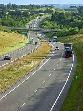
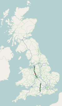
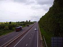
The A34 is a major road in England. It runs from the A33 and M3 at Winchester in Hampshire, to the A6 and A6042 in Salford.[1] It forms a large part of the major trunk route from Southampton, via Oxford, to Birmingham, The Potteries and Manchester. For most of its length (together with the A5011 and parts of the A50, and A49), it forms part of the former Winchester-Preston Trunk Road.[2][3] Improvements to the section of road forming the Newbury Bypass around Newbury were the scene of significant direct action environmental protests in the 1990s.[4] It is 151 miles (243 km) long.
Route
The road is in two sections. The northern section runs south through Manchester and Cheadle, and bypasses Handforth, Wilmslow and Alderley Edge, before passing through Congleton, Newcastle-under-Lyme, and the southern suburbs of Stoke-on-Trent. It then continues south via Stone, Stafford, Cannock and Walsall, passes through the middle of Birmingham (where it briefly merges with the A41), before meeting the M42 motorway at junction 4 south of Solihull.
The road in effect combines with the motorway network and resumes. The southern section begins 45 miles (72 km) SSE (along the M40 motorway), at the Bicester ![]() i/ˈbɪstə/ junction. It continues south as the straightest (western) part of the Oxford Ring Road, crossing the River Thames on the A34 Road Bridge. It then bypasses Abingdon, Didcot, and Newbury before finishing at the southern Winchester turning of the M3 motorway, junction 9. This part of the A34 forms the E05 European route. It is a dual carriageway throughout.
i/ˈbɪstə/ junction. It continues south as the straightest (western) part of the Oxford Ring Road, crossing the River Thames on the A34 Road Bridge. It then bypasses Abingdon, Didcot, and Newbury before finishing at the southern Winchester turning of the M3 motorway, junction 9. This part of the A34 forms the E05 European route. It is a dual carriageway throughout.
Together with parts of the M3 and the M40, the A34 forms an important route carrying freight from Southampton to the Midlands. Because of the volume of traffic, bypasses were built along this route – at Newbury on the A34, and at Twyford Down near Winchester on the M3 – but these were controversial for environmental reasons. Notably instead of cutting a short road tunnel through Twyford Down, the escarpment was carved out for the road traffic of the motorway and fledgling A34.
In 2004 works were carried out, at a cost of £38 million, continuing the road without being interrupted by a roundabout at junction 13 of the M4 motorway, which had caused a "bottleneck".[5]
In Drayton, near Abingdon (Oxfordshire) a junction used by construction vehicles to gain access onto the A34 during its construction still exists as a "closed road", a few miles from the nearest alternative accesses. Plans are in discussion regarding possible re-opening of this closed access point.
Map of route
History and renumbering

The original (1922) route of the A34 was Winchester to Oxford, much shorter than it is today.[6] It was extended to Manchester on 1 April 1935,[7] replacing part of the A42 (Oxford to Birmingham through Shipston-on-Stour, Stratford-upon-Avon and Henley-in-Arden), A455 (Birmingham to Stafford), part of the A449 (Stafford to Newcastle under Lyme) and A526 (Newcastle to Manchester).
By 1953 the route was as follows:[8]
- Manchester
- Levenshulme
- Burnage
- East Didsbury
- Cheadle
- Wilmslow
- Alderley Edge
- Congleton
- Talke
- Newcastle-under-Lyme
- Stone bypass
- Stafford
- Cannock
- Bloxwich
- Walsall
- Birmingham
- Shirley
- Henley-in-Arden
- Wootton Wawen
- Stratford-on-Avon
- Newbold-on-Stour
- Shipston-on-Stour
- Long Compton
- (1 mile (1.6 km) east of Chipping Norton)
- Enstone
- Woodstock
- Oxford
- Abingdon
- Steventon
- East Ilsley
- Newbury
- Litchfield
- Whitchurch
- Sutton Scotney
- Winchester
When the Oxford Ring Road was completed to the west of Oxford in 1962, the old route through the city was renumbered the A4144. On completion of the Abingdon Bypass in the 1970s, the old route from the Oxford Ring Road through Abingdon and Steventon to Chilton was partly declassified (for 5 miles (8.0 km)) and the rest renumbered A4183, B4017, A4130 and A4185.
In 1991, shortly after the completion of the M40 motorway, the road between Oxford and Solihull was renumbered. Between Chipping Norton and Solihull the road lost its primary route status and was renumbered A3400, and south of Chipping Norton the route became part of an extended A44. The A34 was diverted north from the Oxford Ring Road to the M40 along parts of the former routes of the A43 and A421. Much of the long-distance traffic carried by what is now the A3400 now uses the M40 to Birmingham, and the M42 and M6 to by-pass the city.
When the Newbury Bypass was opened in 1998, the old route through Newbury became part of the A339 and the B4640.
The long planned and often postponed Alderley Edge bypass was completed in November 2010, ahead of schedule and within the £52 million budget.[9] The official opening ceremony was conducted by the Chancellor of the Exchequer, the Rt Hon George Osborne MP,[10] on 19 November 2010.
References
- ↑ "1:500,000 road map". Ordnance Survey. Retrieved 22 December 2011.
- ↑ "The Winchester-Preston Trunk Road (A34) (Newbury Bypass Detrunking) (No.2) Order 1993". Retrieved 26 December 2011.
- ↑ "Trunk Roads Acts 1936 and 1946" (PDF). Retrieved 26 December 2011.
- ↑ "1996: Green groups join bypass battle". BBC News. 18 January 1996. Retrieved 22 December 2011.
- ↑ "A34 Chieveley/M4 Junction 13 improvement". Highways Agency. Retrieved 22 December 2011.
- ↑ List Of Class I and Class II Roads and Numbers (transcription) : HMSO
- ↑ The National Archives File MT39/246 : "CLASSIFICATION : Renumbering of classified routes"
- ↑ AA Road Book of England and Wales, 4th edition (1953)
- ↑ Cheshire East Council News Release
- ↑ "Chancellor opens Alderley Edge bypass after 90 year wait". Manchester Evening News. M.E.N. Media. 19 November 2010.
External links
| Wikimedia Commons has media related to A34 road (England). |
- The Highways Agency Management Strategy for Bicester to Winchester.
- The Highways Agency A34-M4 junction improvements.
- A detailed review of the A34 and its history
- A34 Stratford Road red route, Birmingham
A roads in Zone 3 of the Great Britain road numbering scheme | ||
|---|---|---|
| City centre streets | |
|---|---|
| City centre squares | |
| Suburban streets | |
| A roads | |
| Motorways | |
| Defunct | |
| |