A15 motorway (Netherlands)
| |
|---|---|
| Rijksweg 15 | |
|
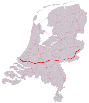
Location of the A15 and A18 motorways | |
| Location | |
| Provinces: | South Holland, Gelderland |
| Highway system | |

The Dutch A15 motorway (Rijksweg 15) is a set of two motorways in the Netherlands, the A15 and the A18.
Connection between A15 and A18
In governmental plans, the A15 and A18 together were meant to be one long motorway from the Europoort harbor near Rotterdam towards the town of Varsseveld in the east of the country. However, the section of this road between the interchange Ressen and Arnhem has never been constructed. To avoid confusion for drivers, the eastern part of the road has been given a different number: 18.
Section A15 (and N15)
The westernmost part of the road, between the Maasvlakte and exit 8 is officially not an Autosnelweg (motorway), and is therefore called N15. However, it has most characteristics of a motorway, such as a central barrier and a hard shoulder until it crosses the Coloradoweg on the Maasvlakte. As of exit 8, the road becomes an official motorway, called A15. Together with the Betuweroute, which runs parallel on several stretches, the A15 is a main transport corridor from the Port of Rotterdam to the east.
Reconstruction works
In 2010, the A15 motorway near Rotterdam has been widened between the exit Brielle and the interchange Vaanplein. To the western part, between Brielle and Spijkenisse, one lane in each direction will be added, making it a 2x3 road. As for the eastern part of the section, between Spijkenisse and the Vaanplein, the current 2x3 road has been upgraded to a 2x5 road. The complex project in this highly industrialized part of Rotterdam caused an extensive loss of € 103,0 million to one of the main contractors of the project, Ballast Nedam, over the year 2014.[1]
Section A18 (and N18)
The A18 motorway is a short motorway, with only 5 exits and 20 kilometers. The western terminus, interchange Oud-Dijk, can only be used by traffic to and from the western part of the A12. Traffic to/from the A12 east of this interchange (most likely from the German BAB 3 road) will have to use local roads to get from the A18 to the A12 or vice versa.
After its eastern terminus near Varsseveld, road number 18 continues as a regional non-motorway road, therefore being called N18. This road passes the towns Harreveld, Lichtenvoorde, Groenlo, and Eibergen on its way to the city Enschede.
Exit list
| Province | Municipality | km | mi | Exit | Name | Destinations | Notes |
|---|---|---|---|---|---|---|---|
| South Holland | Rotterdam | N15 crosses multiple intersections as local road from Maasvlakte | |||||
| Westvoorne | 26 | 16 | 8 | Oostvoorne | East end of N15 designation | ||
| Rotterdam | 27 | 17 | 9 | Havens 6200-7000 | D'arcyweg / Markweg | ||
| 30 | 19 | 10 | Engeland | Rijnweg / Elbeweg | |||
| 33 | 21 | 11 | Havens 5500-5700 | Merwedeweg / Europaweg | |||
| Brielle | 36 | 22 | 12 | Brielle | |||
| Rotterdam | 37 | 23 | 13 | Rozenburg | Droespolderweg / Merseyweg | ||
| 39 | 24 | 14 | Rozenburg-Centrum | Trentweg | |||
| 43 | 27 | 15 | Havens 4100-5200 | Welplaatweg / Clydeweg | |||
| Spijkenisse | 45 | 28 | 16 | Spijkenisse | |||
| Rotterdam | 49 | 30 | 17 | Hoogvliet | Gaderingviaduct / Hoefsmidstraat / Vondelingenweg / Aveling | ||
| 50 | 31 | — | Interchange Benelux | ||||
| 53 | 33 | 18 | Pernis / Heijplaat | ||||
| 54 | 34 | 19 | Charlois | ||||
| 60 | 37 | 19a | Interchange Vaanplein | ||||
| 62 | 39 | 20 | IJsselmonde | ||||
| Ridderkerk | 63 | 39 | — | Interchange Ridderkerk-Noord | West end of E 19 and A16 overlap | ||
| 69 | 43 | — | Interchange Ridderkerk-Zuid | East end of E 19 and A16 overlap; west end of E 31 overlap | |||
| Hendrik-Ido-Ambacht | 72 | 45 | 21 | Hendrik-Ido-Ambacht | |||
| Alblasserdam | 76 | 47 | 22 | Alblasserdam | |||
| Papendrecht | 78 | 48 | 23 | Papendrecht | |||
| Sliedrecht | 81 | 50 | 24 | Sliedrecht-West | Parallelweg / Ouverture | ||
| 86 | 53 | 25 | Sliedrecht-Oost | Sportlaan / Peulenlaan / Buitendams | |||
| Hardinxveld-Giessendam | 88 | 55 | 26 | Hardinxveld-Giessendam | Nieuweweg | ||
| Gorinchem | 95 | 59 | 27 | Gorinchem | |||
| 96 | 60 | — | Interchange Gorinchem | ||||
| Giessenlanden | 100 | 62 | 28 | Arkel | Spijksesteeg | ||
| Leerdam | 106 | 66 | 29 | Leerdam | |||
| Gelderland | Geldermalsen | 115 | 71 | — | Interchange Deil | ||
| 118 | 73 | 30a | Meteren | Eastbound exit and entrance only | |||
| 121 | 75 | 30 | Geldermalsen | ||||
| Tiel | 124 | 77 | 31 | Wadenoijen | Lingedijk | ||
| 127 | 79 | 32 | Tiel-West | ||||
| 131 | 81 | 33 | Tiel | ||||
| Neder-Betuwe | 135 | 84 | 34 | Echteld | |||
| 141 | 88 | 35 | Ochten | ||||
| 147 | 91 | 36 | Dodewaard | Dodewaadsestraat | |||
| Overbetuwe | 151 | 94 | 37 | Zetten | |||
| 154 | 96 | — | Interchange Valburg | East end of E 31 overlap | |||
| 160 | 99 | 38 | Elst | Rijksweg Zuid / Griftdijk | |||
| Lingewaard | 162 | 101 | — | Interchange Ressen | |||
| Gap in route | |||||||
| Montferland | 189 | 117 | — | Interchange Oud-Dijk | West end of A18 designation; only accessible from A12 from the west | ||
| 191 | 119 | 1 | Didam | ||||
| Doetinchem | 196 | 122 | 2 | Wehl | |||
| 200 | 120 | 3 | Doetinchem | West end of N317 overlap | |||
| 202 | 126 | 4 | Doetinchem-Oost | East end of N317 overlap | |||
| Oude IJsselstreek | 211 | 131 | 5 | Varsseveld | East end of A18 designation | ||
1.000 mi = 1.609 km; 1.000 km = 0.621 mi
| |||||||
References
| Wikimedia Commons has media related to Rijksweg 15. |
- ↑ de Voogt, Sam (1 May 2015). "Dramatic loss of 103 million euro". NRC Handelsblad (in Dutch). Retrieved 1 May 2015.