A' Mhaighdean
| A' Mhaighdean | |
|---|---|
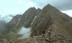
 View of A' Mhaighdean from Slioch | |
| Highest point | |
| Elevation | 967 m (3,173 ft) [1] |
| Prominence | 442 m (1,450 ft) |
| Listing | Munro, Marilyn |
| Coordinates | 57°43′11″N 5°20′46″W / 57.7196°N 5.346°WCoordinates: 57°43′11″N 5°20′46″W / 57.7196°N 5.346°W |
| Naming | |
| Translation | the maiden (Gaelic) |
| Pronunciation | Scottish Gaelic: [ə ˈvɤitʲan] |
| Geography | |
| OS grid | NH007749 |

A' Mhaighdean is one of the least accessible of the munros in northern Scotland. It is 8 miles (13 km) north of Kinlochewe but most easily accessible from Poolewe, taking a private road South East (pedestrian & bicycle access only) to Kernsary. A good track then leads to the causeway between the Fionn Loch and Loch Dubh. Follow the path eastwards to about the 1,000 feet (300 m) level and cross the Allt Bruthach an Esain to gain the North West ridge of the mountain.
The mountain is composed of gneiss, the summit presenting the highest elevation of the Lewisian. Part of the North West ridge is capped by Torridonian sandstone.
Footnotes
- ↑ "walkhighlands A' Mhaighdean". walkhighlands.co.uk. 2014. Retrieved 14 January 2014.
 |
|  | |
This article is issued from Wikipedia - version of the 11/3/2014. The text is available under the Creative Commons Attribution/Share Alike but additional terms may apply for the media files.