Emblem of the 91st Missile Wing
Coordinates: 48°24′57″N 101°21′29″W / 48.41583°N 101.35806°W / 48.41583; -101.35806 (Minot AFB)
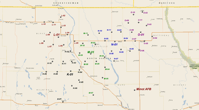
This is a list of the LGM-30 Minuteman missile Missile Alert Facilities and Launch Facilities of the 91st Missile Wing, 20th Air Force, assigned to Minot AFB, North Dakota.
Overview
In November 1962, the 455th Strategic Missile Wing was the fourth United States Air Force LGM-30 Minuteman ICBM wing, the third with the LGM-30B Minuteman I. In 1962 and 1963 150 missiles were deployed to silos controlled by three squadrons of 455th in North Dakota. On 25 June 1968 the 91st Bombardment Wing was reassigned to Minot AFB from Glasgow AFB, Montana which was closed and assumed control of the three Minuteman squadrons of the 455th. The senior 91st SMW had organizational roots dating from World War II and had been deployed from Glasgow AFB to Southeast Asia, where it had been flying combat missions with the B-52 Stratofortress during the Vietnam War. The 455th SMW was inactivated.
Between April 1970 and December 1971 the Minuteman I ICBMs were replaced with the LGM-30G Minuteman III. All of the 91st Wing's Minuteman III missiles were reduced from three warheads to a single warhead by START I between 1991-2001. The three active squadrons are commanded by the 91st Operations Group.
Facilities
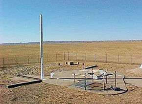
Minuteman III Launch Facility
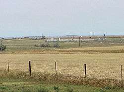
The Missile Alert Facility (MAF) consists of a buried and hardened Launch Control Facility (LCC) and an above-ground Launch Control Support Building (LCSB). MAFs were formerly known as Launch Control Facilities (LCFs) but terminology was changed in 1992 with the inactivation of Strategic Air Command (SAC). In addition, a MAF has a landing pad for helicopters; a large radio tower; a large "top hat" HF antenna; a vehicle garage for security vehicles; recreational facilities, and one or two sewage lagoons. The entire site, except for the helicopter pad and sewage lagoons are secured with a fence and security personnel. About a dozen airmen and officers are assigned to a MAF.
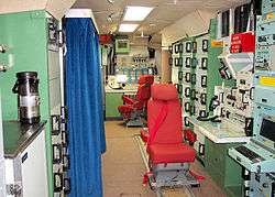
The underground LCC Launch Control Center (LCC) contains the command and control equipment for missile operations. It is staffed by the two launch officers who have primary control and responsibility for the 10 underground and hardened Launch Facilities (LF)s within its flight which contains the operational missile. Each of the five LCCs also has the ability to command and monitor all 50 LFs within the squadron. The LF is unmanned, except when maintenance and security personnel are needed.
A squadron is composed of five flights; flights are denoted by a letter of the alphabet with the facilities controlled by the flight being designated by a number, 01 through 11, with 01 being the MAF.
Units and locations
740th Missile Squadron
Activated by Strategic Air Command on 28 June 1962. Organized on 1 November 1962
Emblem of the 740th Missile Squadron
740th Missile Squadron - Missile Alert Facilities and Launch Facilities
- A-02 9.9 mi SE of Karlsruhe ND, 48°00′04″N 100°27′15″W / 48.00111°N 100.45417°W / 48.00111; -100.45417 (A-02)
- A-03 15.8 mi SE of Karlsruhe ND, 47°56′13″N 100°22′08″W / 47.93694°N 100.36889°W / 47.93694; -100.36889 (A-03)
- A-04 12.8 mi SxSE of Karlsruhe ND, 47°56′00″N 100°28′51″W / 47.93333°N 100.48083°W / 47.93333; -100.48083 (A-04)
- A-05 17.3 mi SxSE of Karlsruhe ND, 47°52′30″N 100°25′59″W / 47.87500°N 100.43306°W / 47.87500; -100.43306 (A-05)
- A-06 18.4 mi SxSE of Karlsruhe ND, 47°50′04″N 100°30′58″W / 47.83444°N 100.51611°W / 47.83444; -100.51611 (A-06)
- A-07 13.8 mi N of Karlsruhe ND, 47°53′37″N 100°35′01″W / 47.89361°N 100.58361°W / 47.89361; -100.58361 (A-07)
- A-08 16.8 mi S of Karlsruhe ND, 47°51′01″N 100°39′32″W / 47.85028°N 100.65889°W / 47.85028; -100.65889 (A-08)
- A-09 6.2 mi SxSW of Karlsruhe ND, 48°00′34″N 100°40′22″W / 48.00944°N 100.67278°W / 48.00944; -100.67278 (A-09)
- A-10 0.8 mi NxNW of Karlsruhe ND, 48°06′09″N 100°37′39″W / 48.10250°N 100.62750°W / 48.10250; -100.62750 (A-10)
- A-11 4.1 mi SxSE of Karlsruhe ND, 48°02′09″N 100°35′20″W / 48.03583°N 100.58889°W / 48.03583; -100.58889 (A-11)
- B-02 4.4 mi ExNE of Velva ND, 48°04′33″N 100°50′26″W / 48.07583°N 100.84056°W / 48.07583; -100.84056 (B-02)
- B-03 9.1 mi E of Velva ND, 48°04′17″N 100°44′08″W / 48.07139°N 100.73556°W / 48.07139; -100.73556 (B-03)
- B-04 6.9 mi SE of Velva ND, 47°59′32″N 100°49′16″W / 47.99222°N 100.82111°W / 47.99222; -100.82111 (B-04)
- B-05 10.5 mi SxSE of Velva ND, 47°55′38″N 100°49′15″W / 47.92722°N 100.82083°W / 47.92722; -100.82083 (B-05)
- B-06 15.1 mi SxSE of Velva ND, 47°51′41″N 100°47′55″W / 47.86139°N 100.79861°W / 47.86139; -100.79861 (B-06)
- B-07 15.8 mi S of Velva ND, 47°49′53″N 100°55′37″W / 47.83139°N 100.92694°W / 47.83139; -100.92694 (B-07)
- B-08 13.8 mi SxSW of Velva ND, 47°53′13″N 101°04′52″W / 47.88694°N 101.08111°W / 47.88694; -101.08111 (B-08)
- B-09 10.0 mi SW of Velva ND, 47°57′03″N 101°04′24″W / 47.95083°N 101.07333°W / 47.95083; -101.07333 (B-09)
- B-10 6.0 mi SxSW of Velva ND, 47°58′46″N 100°58′49″W / 47.97944°N 100.98028°W / 47.97944; -100.98028 (B-10)
- B-11 1.4 mi S of Velva ND, 48°02′22″N 100°55′51″W / 48.03944°N 100.93083°W / 48.03944; -100.93083 (B-11)
- C-02 16.2 mi N of Turtle Lake ND, 47°45′12″N 100°54′33″W / 47.75333°N 100.90917°W / 47.75333; -100.90917 (C-02)
- C-03 18.7 mi NxNE of Turtle Lake ND, 47°47′02″N 100°48′05″W / 47.78389°N 100.80139°W / 47.78389; -100.80139 (C-03)
- C-04 11.2 mi N of Turtle Lake ND, 47°40′52″N 100°54′14″W / 47.68111°N 100.90389°W / 47.68111; -100.90389 (C-04)
- C-05 5.9 mi N of Turtle Lake ND, 47°36′16″N 100°52′19″W / 47.60444°N 100.87194°W / 47.60444; -100.87194 (C-05)
- C-06 8.8 mi NxNW of Turtle Lake ND, 47°38′00″N 100°58′25″W / 47.63333°N 100.97361°W / 47.63333; -100.97361 (C-06)
- C-07 10.0 mi WxNW of Turtle Lake ND, 47°35′27″N 101°04′36″W / 47.59083°N 101.07667°W / 47.59083; -101.07667 (C-07)
- C-08 12.9 mi NW of Turtle Lake ND, 47°39′29″N 101°04′35″W / 47.65806°N 101.07639°W / 47.65806; -101.07639 (C-08)
- C-09 17.9 mi NW of Turtle Lake ND, 47°42′07″N 101°09′46″W / 47.70194°N 101.16278°W / 47.70194; -101.16278 (C-09)
- C-10 18.7 mi NxNW of Turtle Lake ND, 47°45′32″N 101°04′37″W / 47.75889°N 101.07694°W / 47.75889; -101.07694 (C-10)
- C-11 21.6 mi NxNW of Turtle Lake ND, 47°49′05″N 101°01′37″W / 47.81806°N 101.02694°W / 47.81806; -101.02694 (C-11)
|
- D-02 6.5 mi N of Max ND, 47°54′56″N 101°17′47″W / 47.91556°N 101.29639°W / 47.91556; -101.29639 (D-02)
- D-03 5.4 mi NE of Max ND, 47°52′26″N 101°12′33″W / 47.87389°N 101.20917°W / 47.87389; -101.20917 (D-03)
- D-04 5.8 mi ExSE of Max ND, 47°46′35″N 101°11′30″W / 47.77639°N 101.19167°W / 47.77639; -101.19167 (D-04)
- D-05 10.9 mi S of Max ND, 47°39′48″N 101°17′09″W / 47.66333°N 101.28583°W / 47.66333; -101.28583 (D-05)
- D-06 6.4 mi S of Max ND, 47°43′44″N 101°17′27″W / 47.72889°N 101.29083°W / 47.72889; -101.29083 (D-06)
- D-07 11.9 mi SxSW of Max ND, 47°39′43″N 101°23′42″W / 47.66194°N 101.39500°W / 47.66194; -101.39500 (D-07)
- D-08 8.5 mi SW of Max ND, 47°43′49″N 101°25′13″W / 47.73028°N 101.42028°W / 47.73028; -101.42028 (D-08)
- D-09 6.1 mi WxSW of Max ND, 47°47′33″N 101°25′14″W / 47.79250°N 101.42056°W / 47.79250; -101.42056 (D-09)
- D-10 8.2 mi WxNW of Max ND, 47°51′39″N 101°27′50″W / 47.86083°N 101.46389°W / 47.86083; -101.46389 (D-10)
- D-11 3.9 mi NW of Max ND, 47°51′51″N 101°21′00″W / 47.86417°N 101.35000°W / 47.86417; -101.35000 (D-11)
- E-02 10.5 mi SE of Ryder ND, 47°48′12″N 101°31′25″W / 47.80333°N 101.52361°W / 47.80333; -101.52361 (E-02)
- E-03 15.6 mi SxSE of Ryder ND, 47°43′06″N 101°31′09″W / 47.71833°N 101.51917°W / 47.71833; -101.51917 (E-03)
- E-04 20.9 mi SxSE of Ryder ND, 47°38′26″N 101°29′45″W / 47.64056°N 101.49583°W / 47.64056; -101.49583 (E-04)
- E-05 19.0 mi S of Ryder ND, 47°38′52″N 101°35′50″W / 47.64778°N 101.59722°W / 47.64778; -101.59722 (E-05)
- E-06 16.2 mi S of Ryder ND, 47°41′00″N 101°40′53″W / 47.68333°N 101.68139°W / 47.68333; -101.68139 (E-06)
- E-07 19.3 mi SxSW of Ryder ND, 47°38′43″N 101°45′43″W / 47.64528°N 101.76194°W / 47.64528; -101.76194 (E-07)
- E-08 17.7 mi SxSW of Ryder ND, 47°41′14″N 101°50′16″W / 47.68722°N 101.83778°W / 47.68722; -101.83778 (E-08)
- E-09 20.0 mi SW of Ryder ND, 47°41′21″N 101°56′05″W / 47.68917°N 101.93472°W / 47.68917; -101.93472 (E-09)
- E-10 15.4 mi SW of Ryder ND, 47°44′52″N 101°53′07″W / 47.74778°N 101.88528°W / 47.74778; -101.88528 (E-10)
- E-11 10.9 mi SW of Ryder ND, 47°47′16″N 101°48′23″W / 47.78778°N 101.80639°W / 47.78778; -101.80639 (E-11)
|
741st Missile Squadron
Activated by Strategic Air Command on 28 June 1962. Organized on 1 December 1962
Emblem of the 741st Missile Squadron
741st Missile Squadron - Missile Alert Facilities and Launch Facilities
- F-02 5.8 mi E of Makoti ND, 47°57′55″N 101°40′37″W / 47.96528°N 101.67694°W / 47.96528; -101.67694 (F-02)
- F-03 10.5 mi E of Makoti ND, 47°58′46″N 101°34′35″W / 47.97944°N 101.57639°W / 47.97944; -101.57639 (F-03)
- F-04 13.3 mi ExSE of Makoti ND, 47°55′18″N 101°31′18″W / 47.92167°N 101.52167°W / 47.92167; -101.52167 (F-04)
- F-05 12.2 mi SE of Makoti ND, 47°51′40″N 101°35′11″W / 47.86111°N 101.58639°W / 47.86111; -101.58639 (F-05)
- F-06 7.2 mi SxSE of Makoti ND, 47°51′40″N 101°45′43″W / 47.86111°N 101.76194°W / 47.86111; -101.76194 (F-06)
- F-07 9.5 mi SxSW of Makoti ND, 47°50′03″N 101°52′48″W / 47.83417°N 101.88000°W / 47.83417; -101.88000 (F-07)
- F-08 8.3 mi SW of Makoti ND, 47°53′30″N 101°56′54″W / 47.89167°N 101.94833°W / 47.89167; -101.94833 (F-08)
- F-09 3.6 mi SW of Makoti ND, 47°55′07″N 101°50′41″W / 47.91861°N 101.84472°W / 47.91861; -101.84472 (F-09)
- F-10 4.6 mi WxNW of Makoti ND, 47°58′46″N 101°53′49″W / 47.97944°N 101.89694°W / 47.97944; -101.89694 (F-10)
- F-11 1.1 mi NxNE of Makoti ND, 47°58′35″N 101°47′32″W / 47.97639°N 101.79222°W / 47.97639; -101.79222 (F-11)
- G-02 11.6 mi N of Plaza ND, 48°11′00″N 101°56′51″W / 48.18333°N 101.94750°W / 48.18333; -101.94750 (G-02)
- G-03 8.5 mi NxNE of Plaza ND, 48°07′09″N 101°51′32″W / 48.11917°N 101.85889°W / 48.11917; -101.85889 (G-03)
- G-04 10.3 mi ExNE of Plaza ND, 48°03′11″N 101°44′34″W / 48.05306°N 101.74278°W / 48.05306; -101.74278 (G-04)
- G-05 5.4 mi ExNE of Plaza ND, 48°03′03″N 101°51′17″W / 48.05083°N 101.85472°W / 48.05083; -101.85472 (G-05)
- G-06 1.9 mi N of Plaza ND, 48°02′35″N 101°57′50″W / 48.04306°N 101.96389°W / 48.04306; -101.96389 (G-06)
- G-07 5.9 mi WxNW of Plaza ND, 48°03′15″N 102°04′19″W / 48.05417°N 102.07194°W / 48.05417; -102.07194 (G-07)
- G-08 9.1 mi NW of Plaza ND, 48°07′23″N 102°04′29″W / 48.12306°N 102.07472°W / 48.12306; -102.07472 (G-08)
- G-09 13.2 mi NW of Plaza ND, 48°08′16″N 102°10′38″W / 48.13778°N 102.17722°W / 48.13778; -102.17722 (G-09)
- G-10 17.8 mi NW of Plaza ND, 48°12′05″N 102°13′33″W / 48.20139°N 102.22583°W / 48.20139; -102.22583 (G-10)
- G-11 13.8 mi NxNW of Plaza ND, 48°12′01″N 102°04′29″W / 48.20028°N 102.07472°W / 48.20028; -102.07472 (G-11)
- H-02 7.6 mi NxNW of Parshall ND, 48°03′37″N 102°10′42″W / 48.06028°N 102.17833°W / 48.06028; -102.17833 (H-02)
- H-03 2.7 mi N of Parshall ND, 47°59′35″N 102°07′37″W / 47.99306°N 102.12694°W / 47.99306; -102.12694 (H-03)
- H-04 6.5 mi ExNE of Parshall ND, 47°58′36″N 101°59′48″W / 47.97667°N 101.99667°W / 47.97667; -101.99667 (H-04)
- H-05 6.2 mi SE of Parshall ND, 47°53′23″N 102°02′26″W / 47.88972°N 102.04056°W / 47.88972; -102.04056 (H-05)
- H-06 2.3 mi S of Parshall ND, 47°55′20″N 102°07′51″W / 47.92222°N 102.13083°W / 47.92222; -102.13083 (H-06)
- H-07 7.0 mi S of Parshall ND, 47°51′13″N 102°07′36″W / 47.85361°N 102.12667°W / 47.85361; -102.12667 (H-07)
- H-08 6.0 mi SW of Parshall ND, 47°53′19″N 102°12′59″W / 47.88861°N 102.21639°W / 47.88861; -102.21639 (H-08)
- H-09 14.6 mi W of Parshall ND, 47°58′35″N 102°26′48″W / 47.97639°N 102.44667°W / 47.97639; -102.44667 (H-09)
- H-10 9.8 mi W of Parshall ND, 47°58′49″N 102°20′28″W / 47.98028°N 102.34111°W / 47.98028; -102.34111 (H-10)
- H-11 11.8 mi NW of Parshall ND, 48°05′47″N 102°16′35″W / 48.09639°N 102.27639°W / 48.09639; -102.27639 (H-11)
|
- I-02 10.6 mi ExNE of Stanley ND, 48°22′17″N 102°10′24″W / 48.37139°N 102.17333°W / 48.37139; -102.17333 (I-02)
- I-03 8.2 mi ExSE of Stanley ND, 48°16′20″N 102°13′22″W / 48.27222°N 102.22278°W / 48.27222; -102.22278 (I-03)
- I-04 7.7 mi SxSE of Stanley ND, 48°12′29″N 102°21′19″W / 48.20806°N 102.35528°W / 48.20806; -102.35528 (I-04)
- I-05 2.6 mi SxSE of Stanley ND, 48°16′46″N 102°22′37″W / 48.27944°N 102.37694°W / 48.27944; -102.37694 (I-05)
- I-06 6.7 mi SxSW of Stanley ND, 48°13′58″N 102°27′46″W / 48.23278°N 102.46278°W / 48.23278; -102.46278 (I-06)
- I-07 5.1 mi W of Stanley ND, 48°18′41″N 102°29′59″W / 48.31139°N 102.49972°W / 48.31139; -102.49972 (I-07)
- I-08 9.9 mi W of Stanley ND, 48°19′32″N 102°36′08″W / 48.32556°N 102.60222°W / 48.32556; -102.60222 (I-08)
- I-09 4.7 mi N of Stanley ND, 48°23′04″N 102°24′06″W / 48.38444°N 102.40167°W / 48.38444; -102.40167 (I-09)
- I-10 7.8 mi NxNW of Stanley ND, 48°25′02″N 102°27′59″W / 48.41722°N 102.46639°W / 48.41722; -102.46639 (I-10)
- I-11 9.8 mi N of Stanley ND, 48°27′27″N 102°24′35″W / 48.45750°N 102.40972°W / 48.45750; -102.40972 (I-11)
- J-02 10.5 mi NxNW of Berthold ND, 48°27′20″N 101°49′11″W / 48.45556°N 101.81972°W / 48.45556; -101.81972 (J-02)
- J-03 5.2 mi N of Berthold ND, 48°23′22″N 101°43′55″W / 48.38944°N 101.73194°W / 48.38944; -101.73194 (J-03)
- J-04 1.7 mi WxNW of Berthold ND, 48°19′33″N 101°46′10″W / 48.32583°N 101.76944°W / 48.32583; -101.76944 (J-04)
- J-05 6.8 mi WxNW of Berthold ND, 48°20′52″N 101°52′35″W / 48.34778°N 101.87639°W / 48.34778; -101.87639 (J-05)
- J-06 9.7 mi WxSW of Berthold ND, 48°17′10″N 101°56′32″W / 48.28611°N 101.94222°W / 48.28611; -101.94222 (J-06)
- J-07 11.3 mi WxNW of Berthold ND, 48°21′17″N 101°58′26″W / 48.35472°N 101.97389°W / 48.35472; -101.97389 (J-07)
- J-08 15.5 mi W of Berthold ND, 48°17′21″N 102°04′18″W / 48.28917°N 102.07167°W / 48.28917; -102.07167 (J-08)
- J-09 15.7 mi WxNW of Berthold ND, 48°21′38″N 102°04′18″W / 48.36056°N 102.07167°W / 48.36056; -102.07167 (J-09)
- J-10 14.8 mi WxNW of Berthold ND, 48°25′11″N 102°01′06″W / 48.41972°N 102.01833°W / 48.41972; -102.01833 (J-10)
- J-11 14.5 mi NxNW of Berthold ND, 48°29′31″N 101°54′23″W / 48.49194°N 101.90639°W / 48.49194; -101.90639 (J-11)
|
742d Missile Squadron
Activated by Strategic Air Command on 18 July 1962. Organized on 1 January 1963
Emblem of the 742d Missile Squadron
742d Missile Squadron - Missile Alert Facilities and Launch Facilities
- K-02 2.3 mi WxNW of Kenmare ND, 48°41′32″N 102°07′24″W / 48.69222°N 102.12333°W / 48.69222; -102.12333 (K-02)
- K-03 4.0 mi SxSW of Kenmare ND, 48°37′11″N 102°06′24″W / 48.61972°N 102.10667°W / 48.61972; -102.10667 (K-03)
- K-04 8.6 mi SxSE of Kenmare ND, 48°33′31″N 102°00′54″W / 48.55861°N 102.01500°W / 48.55861; -102.01500 (K-04)
- K-05 13.3 mi SxSE of Kenmare ND, 48°29′14″N 102°01′07″W / 48.48722°N 102.01861°W / 48.48722; -102.01861 (K-05)
- K-06 15.8 mi S of Kenmare ND, 48°26′51″N 102°06′17″W / 48.44750°N 102.10472°W / 48.44750; -102.10472 (K-06)
- K-07 15.6 mi SxSW of Kenmare ND, 48°28′00″N 102°12′38″W / 48.46667°N 102.21056°W / 48.46667; -102.21056 (K-07)
- K-08 12.8 mi SW of Kenmare ND, 48°32′42″N 102°16′45″W / 48.54500°N 102.27917°W / 48.54500; -102.27917 (K-08)
- K-09 17.5 mi WxSW of Kenmare ND, 48°32′40″N 102°24′37″W / 48.54444°N 102.41028°W / 48.54444; -102.41028 (K-09)
- K-10 12.3 mi WxSW of Kenmare ND, 48°37′03″N 102°20′12″W / 48.61750°N 102.33667°W / 48.61750; -102.33667 (K-10)
- K-11 10.3 mi WxNW of Kenmare ND, 48°37′04″N 102°12′32″W / 48.61778°N 102.20889°W / 48.61778; -102.20889 (K-11)
- L-02 8.8 mi N of Bowbells ND, 48°55′51″N 102°14′28″W / 48.93083°N 102.24111°W / 48.93083; -102.24111 (L-02)
- L-03 3.9 mi N of Bowbells ND, 48°51′33″N 102°14′15″W / 48.85917°N 102.23750°W / 48.85917; -102.23750 (L-03)
- L-04 3.9 mi E of Bowbells ND, 48°48′31″N 102°09′38″W / 48.80861°N 102.16056°W / 48.80861; -102.16056 (L-04)
- L-05 8.3 mi ExSE of Bowbells ND, 48°45′44″N 102°04′29″W / 48.76222°N 102.07472°W / 48.76222; -102.07472 (L-05)
- L-06 5.0 mi SxSE of Bowbells ND, 48°44′09″N 102°12′14″W / 48.73583°N 102.20389°W / 48.73583; -102.20389 (L-06)
- L-07 6.0 mi SW of Bowbells ND, 48°44′13″N 102°19′46″W / 48.73694°N 102.32944°W / 48.73694; -102.32944 (L-07)
- L-08 9.3 mi WxSW of Bowbells ND, 48°45′38″N 102°26′18″W / 48.76056°N 102.43833°W / 48.76056; -102.43833 (L-08)
- L-09 5.8 mi WxNW of Bowbells ND, 48°49′15″N 102°22′10″W / 48.82083°N 102.36944°W / 48.82083; -102.36944 (L-09)
- L-10 10.9 mi NW of Bowbells ND, 48°53′44″N 102°26′22″W / 48.89556°N 102.43944°W / 48.89556; -102.43944 (L-10)
- L-11 7.4 mi NxNW of Bowbells ND, 48°53′34″N 102°19′57″W / 48.89278°N 102.33250°W / 48.89278; -102.33250 (L-11)
- M-02 6.8 mi E of Norma ND, 48°44′42″N 101°49′33″W / 48.74500°N 101.82583°W / 48.74500; -101.82583 (M-02)
- M-03 13.1 mi ExSE of Norma ND, 48°38′58″N 101°42′49″W / 48.64944°N 101.71361°W / 48.64944; -101.71361 (M-03)
- M-04 15.9 mi SE of Norma ND, 48°34′39″N 101°42′37″W / 48.57750°N 101.71028°W / 48.57750; -101.71028 (M-04)
- M-05 10.5 mi SE of Norma ND, 48°37′11″N 101°48′45″W / 48.61972°N 101.81250°W / 48.61972; -101.81250 (M-05)
- M-06 18.8 mi SE of Norma ND, 48°30′15″N 101°44′25″W / 48.50417°N 101.74028°W / 48.50417; -101.74028 (M-06)
- M-07 13.7 mi SxSE of Norma ND, 48°32′58″N 101°50′39″W / 48.54944°N 101.84417°W / 48.54944; -101.84417 (M-07)
- M-08 7.6 mi S of Norma ND, 48°37′11″N 101°56′54″W / 48.61972°N 101.94833°W / 48.61972; -101.94833 (M-08)
- M-09 4.0 mi SxSW of Norma ND, 48°40′40″N 102°00′46″W / 48.67778°N 102.01278°W / 48.67778; -102.01278 (M-09)
- M-10 1.2 mi N of Norma ND, 48°44′45″N 101°58′33″W / 48.74583°N 101.97583°W / 48.74583; -101.97583 (M-10)
- M-11 6.0 mi NxNE of Norma ND, 48°48′21″N 101°54′48″W / 48.80583°N 101.91333°W / 48.80583; -101.91333 (M-11)
|
- N-02 8.9 mi NxNW of Mohall ND, 48°53′19″N 101°33′51″W / 48.88861°N 101.56417°W / 48.88861; -101.56417 (N-02)
- N-03 4.3 mi N of Mohall ND, 48°49′37″N 101°31′11″W / 48.82694°N 101.51972°W / 48.82694; -101.51972 (N-03)
- N-04 1.8 mi E of Mohall ND, 48°45′54″N 101°28′16″W / 48.76500°N 101.47111°W / 48.76500; -101.47111 (N-04)
- N-05 6.8 mi SE of Mohall ND, 48°41′32″N 101°24′38″W / 48.69222°N 101.41056°W / 48.69222; -101.41056 (N-05)
- N-06 4.3 mi S of Mohall ND, 48°42′11″N 101°31′05″W / 48.70306°N 101.51806°W / 48.70306; -101.51806 (N-06)
- N-07 10.7 mi SxSW of Mohall ND, 48°37′20″N 101°36′06″W / 48.62222°N 101.60167°W / 48.62222; -101.60167 (N-07)
- N-08 7.4 mi SW of Mohall ND, 48°41′31″N 101°37′50″W / 48.69194°N 101.63056°W / 48.69194; -101.63056 (N-08)
- N-09 9.1 mi W of Mohall ND, 48°45′54″N 101°42′36″W / 48.76500°N 101.71000°W / 48.76500; -101.71000 (N-09)
- N-10 12.8 mi WxNW of Mohall ND, 48°49′06″N 101°46′46″W / 48.81833°N 101.77944°W / 48.81833; -101.77944 (N-10)
- N-11 6.8 mi NW of Mohall ND, 48°49′32″N 101°37′47″W / 48.82556°N 101.62972°W / 48.82556; -101.62972 (N-11)
- O-02 17.8 mi NxNW of Maxbass ND, 48°58′01″N 101°15′36″W / 48.96694°N 101.26000°W / 48.96694; -101.26000 (O-02)
- O-03 10.8 mi NxNW of Maxbass ND, 48°52′13″N 101°12′40″W / 48.87028°N 101.21111°W / 48.87028; -101.21111 (O-03)
- O-04 5.0 mi N of Maxbass ND, 48°47′39″N 101°08′40″W / 48.79417°N 101.14444°W / 48.79417; -101.14444 (O-04)
- O-05 5.1 mi WxNW of Maxbass ND, 48°45′42″N 101°14′14″W / 48.76167°N 101.23722°W / 48.76167; -101.23722 (O-05)
- O-06 7.4 mi WxSW of Maxbass ND, 48°41′56″N 101°18′05″W / 48.69889°N 101.30139°W / 48.69889; -101.30139 (O-06)
- O-07 9.8 mi WxNW of Maxbass ND, 48°45′43″N 101°20′54″W / 48.76194°N 101.34833°W / 48.76194; -101.34833 (O-07)
- O-08 13.3 mi WxNW of Maxbass ND, 48°49′28″N 101°23′19″W / 48.82444°N 101.38861°W / 48.82444; -101.38861 (O-08)
- O-09 17.5 mi NW of Maxbass ND, 48°53′26″N 101°25′47″W / 48.89056°N 101.42972°W / 48.89056; -101.42972 (O-09)
- O-10 18.7 mi NxNW of Maxbass ND, 48°56′54″N 101°22′01″W / 48.94833°N 101.36694°W / 48.94833; -101.36694 (O-10)
- O-11 14.0 mi NxNW of Maxbass ND, 48°53′33″N 101°18′25″W / 48.89250°N 101.30694°W / 48.89250; -101.30694 (O-11)
|
References
 This article incorporates public domain material from the Air Force Historical Research Agency website http://www.afhra.af.mil/.
External links
| Links to related articles |
|---|
|
|
|---|
| | Leadership | | |
|---|
| | Structure | |
|---|
| Personnel and
training | |
|---|
| Uniforms and
equipment | |
|---|
| History and
traditions | |
|---|
|
-
 Category Category
-
 Portal Portal
|
|
|---|
| | Bases | | |
|---|
| | Units | | Air Forces | |
|---|
| | Wings | | Air Base | |
|---|
| | Bomb | |
|---|
| | Missile | |
|---|
| | Nuclear Systems | |
|---|
|
|---|
| | Groups | |
|---|
| | Squadrons | | Bomb | |
|---|
| | Combat Training | |
|---|
| | Flight test | |
|---|
| | Missile | |
|---|
| | Helicopter | |
|---|
| | Strategic Operations | |
|---|
| | Training | |
|---|
|
|---|
|
|---|
| Weapon
systems | | Bombers | |
|---|
| | Command | |
|---|
| | Helicopters | |
|---|
| | Missiles | |
|---|
|
|---|
| | Leadership | |
|---|
|
|---|
| | | | Wings |
|---|
| | Combat Communications | |
|---|
| | Information Operations | |
|---|
| | Network Warfare | |
|---|
| | Space | |
|---|
|
| | | Groups |
|---|
| | Air Base | |
|---|
| | Combat Communications | |
|---|
| | Cyberspace Engineering Installation | |
|---|
| | Information Operations | |
|---|
| | Network Operations | |
|---|
| | Network Support | |
|---|
| | Network Warfare | |
|---|
|
| | | Squadrons |
|---|
| | Combat Communications | |
|---|
| | Command and Control | |
|---|
| | Space Control | |
|---|
| | Space Launch | |
|---|
| | Space Operations | |
|---|
| | Space Warning | |
|---|
| | Others | |
|---|
|
|
|
|---|
| | Bases | | |
|---|
| | Units | | Air Forces | |
|---|
| | Divisions | | Air | |
|---|
| Strategic
Aerospace | |
|---|
| | Strategic Missile | |
|---|
|
|---|
| | Wings | |
|---|
| USAAF
Groups
*=Initial Assigned
Unit Upon SAC's
Activation | | Bombardment | |
|---|
| | Fighter | |
|---|
| | Reconnaissance | |
|---|
|
|---|
|
|---|
| Major
weapon
systems | | Bombers | |
|---|
| Command
& Control | |
|---|
| | Fighters | |
|---|
| | Missiles | |
|---|
| | Reconnaissance | |
|---|
| | Tankers | |
|---|
| | Transport | |
|---|
|
|---|
| | Commanders | |
|---|
| | Emblems | |
|---|
|