400-series highways
| 400-series highways | |
|---|---|
|
Highway markers for Highway 403 and the Queen Elizabeth Way | |
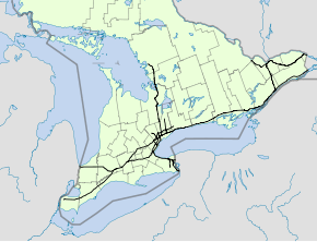
|
The current 400-series Highway network in Southern Ontario | |
| System information | |
| Maintained by Ministry of Transportation of Ontario (MTO) | |
| Length: | 1,957.4 km[1] (1,216.3 mi) |
| Formed: | July 1, 1952 |
| Highway names | |
| Provincial | Ontario Highway X |
| System links | |


The 400-series highways are a network of controlled-access highways throughout the southern portion of the Canadian province of Ontario, forming a special subset of the provincial highway system. They are analogous to the Interstate Highway System in the United States or the Autoroute system of neighbouring Quebec, but under provincial jurisdiction and regulated by the Ministry of Transportation of Ontario (MTO). Although Ontario had been constructing divided highways for two decades prior, 400-series designations were introduced in 1952. Initially only Highways 400, 401 and 402 were numbered; other designations followed in the subsequent decades.
Modern 400-series highways have high design standards, speed limits of 100 kilometres per hour (60 mph), and various collision avoidance and traffic management systems. The design of 400-series highways has set the precedent for a number of innovations used throughout North America, including the parclo interchange and a modified Jersey barrier design known as Ontario Tall Wall. As a result, they currently experience the lowest accident and fatality rate comparative to traffic volume in North America.
History
When the 400-series designations were first applied to Ontario freeways in 1952,[2] several divided highways were already opened in Southern Ontario.[3] Originally inspired by German Autobahns, Thomas McQuesten planned a network of "Dual Highways" across the southern half of the province.[4][5] The Queen Elizabeth Way (QEW) was first, an upgrade to the partially constructed Middle Road in 1934.[6] McQuesten also sought out the economic opportunity that came with linking Toronto to Detroit and New York by divided roadways with interchanges at major crossroads, Although he no longer served as Minister of Highways by the onset of World War II, his ambitious plans would come to fruition in the following decades as Highways 400, 401, 402, 403 (between Woodstock and Hamilton) and 405.[7]
The construction boom that followed World War II resulted in a great number of new freeway construction projects in the province. The Toronto–Barrie Highway (Highway 400), Trans-Provincial Highway (Highway 401),[8] a short expansion of Highway 7 approaching the Blue Water Bridge in Sarnia (Highway 402),[9] and an expansion of Highway 27 into part of the Toronto Bypass were all underway or completed by the early 1950s.[8] Seeking a new way to distinguish the controlled-access freeways from the existing two lane King's Highway networks, the Department of Highways created the 400-series designations in 1952. By the end of the year, Highway 400, 401 and 402 were numbered, though only short stubs of their current lengths.[2] Highway 401 was assembled across the province in a patchwork fashion,[8] becoming fully navigable between Windsor and Quebec on November 10, 1964;[10] Highway 400 was extended north to Coldwater on Christmas Eve, 1959;[11] Highway 402 was extended to London between 1972 and 1982.[12][13]
In addition to this network backbone, plans for additional 400-series highways were initiated by the late 1950s, comprising the Chedoke Expressway (Highway 403) through Hamilton;[14] the Don Valley Parkway Extension (Highway 404) northward from the soon-to-be constructed Toronto expressway;[15] Highway 405 to connect with the American border near St. Catharines;[16] Highway 406 south from St. Catharines to Welland;[17] Highway 407 encircling the Greater Toronto Area (GTA), though not built for another 40 years;[18] Highway 409 to connect Highway 401 with Toronto Pearson Airport;[19] and The Queensway (Highway 417) through Ottawa.[20] The first sections of these freeways were opened in 1963,[21] 1977,[22] 1963,[21] 1965,[23] 1997,[24] 1974,[25] and 1960,[26] respectively.
Throughout the 1960s and 1970s, additional freeways were planned or built, including Highway 427 in Toronto,[27] Highway 403 through Mississauga,[28] Highway 410 north to Brampton and Highway 416 to connect Highways 401 and 417.[29][30] Highway 420 was designated in Niagara Falls,[2][31] though it had been built as part of the QEW in 1941.[32] Other major works included the skyway bridges along the QEW and the expansion of Highway 401 into twelve lane collector-express systems.[8][33][34]
By the mid-1980s, the network had more-or-less taken its current shape, with only Highways 407 and 416 not yet built.[35][36] Instead, emphasis was placed on expanding existing routes to accommodate increasing traffic volumes.[18] However, extensions of Highway 400 towards Parry Sound,[37] Highway 403 between Woodstock and Hamilton,[38] Highway 404 towards Newmarket,[39] and Highway 427 towards Vaughan were underway.[40] By the end of the decade, construction of Highway 407 and Highway 416 had begun,[18][41] and Highway 410 was expanded from two to four lanes.[42]
Highways 407 and 416 opened in the late 1990s.[24][43] Until early 2015, Highways 407 and 416 were the most-recently designated (and constructed) freeways in Ontario. This has changed with the designation of Highways 412 and 418. In addition to these new additions to the 400-series network, several extensions of existing freeways have been built or are underway,[36] including Highway 410 north of Brampton in 2009,[44] Highway 400 to north of Parry Sound in 2010,[45] Highway 417 to Arnprior in 2012,[46] Highway 404 to Keswick in 2014,[47] Highway 401 through Windsor in 2015,[48] and four-laning Highway 406 to Welland in late 2015.[49]
Design standards
While older freeways have some lapses in safety features, contemporary 400-series highways have design speeds of 130 km/h (81 mph), speed limits of 100 km/h (62 mph), various collision avoidance and traffic management systems, and several design standards adopted throughout North America.[50] Of note are the Ontario Tall Wall median barrier and the Parclo A-4 interchange design, the latter which became standard in the design for the widening of Highway 401 through Toronto in 1962. The Institute of Traffic Engineers subsequently recommended this design to replace the cloverleaf interchange throughout North America.[51][52] Highways in Ontario are among the safest in North America, with 0.63 fatalities per 10,000 licensed drivers in 2010.[53]
Conforming with the Manual on Uniform Traffic Control Devices, Ontario utilizes green signs for guidance purposes (including distances to nearby interchanges and destinations).[54] Generally, blue signage is used to list services and attractions at upcoming exits, known as Tourism-Oriented Directional Signing.[55] However, several exceptions exist, notably signage for toll highways like Highway 407, in addition to the collector lanes of highways in the GTA.[54] The baseline standard for the construction of or expansion to a freeway in Ontario is an average daily traffic count of 10,000 vehicles per day. However, other factors are considered as well, particularly future traffic volume forecasts. To promote economic development in a disadvantaged region (e.g., the current extension of Highway 400 to Northern Ontario), a 400-series highway may be built where the existing highway's traffic counts fall below 10,000.[56]
The MTO plans and finances the construction and maintenance of the King's Highway system, which includes the 400-series network.[57] The system includes 1,957.4 kilometres (1,216.3 mi) of freeways. Highway 401 is the longest freeway at 828.0 kilometres (514.5 mi), in addition to being the widest and busiest road in Canada. Highway 420 is the shortest of the routes at 3.3 kilometres (2.1 mi).[1]
High-occupancy vehicle lanes

The MTO began planning for the use of high-occupancy vehicle (HOV) lanes with the HOV Opportunities Study, contracted to McCormick Rankin in 2001. This led to the test trial of three HOV lanes in the GTA in December 2005: southbound Highway 404 between Markham and Highway 401, with a dedicated HOV ramp built to connect with westbound Highway 401, and Highway 403 in both directions within Mississauga.[58] Since then, HOV lanes have been opened on several 400-series freeways around the Golden Horseshoe and National Capital Region. In May 2007, the MTO introduced a multibillion-dollar Horseshoe Network Project, which included plans to incorporate HOV lanes into numerous 400-series highways.[59]
By then, work was already advanced on several projects, including the northbound HOV lane on Highway 404 (that opened on July 23, 2007) and an HOV lane along both directions of Highway 403 between Highway 407 and Highway 401. A third pair of HOV lanes has since been introduced to the QEW/403 through Oakville, and a fourth individual HOV lane travels eastbound on Highway 417 from just west of Eagleson Road in Ottawa to just east of Moodie Drive.[59]
More than 450 kilometres (280 mi) of HOV lanes are currently proposed for construction by 2031. Future plans include extending existing HOV lanes and introducing them to other 400-series freeways.[60] However, as of October 2014, only two projects have been confirmed: Highway 410 between Highway 401 and Queen Street in Brampton, and Highway 427 between Highway 409 and Highway 7. The MTO has stated that HOV lanes will only be introduced through new construction, and that no general purpose lanes will be converted. The general goals of the project are to help increase highway efficiency (an HOV lane is claimed by the Ontario government to have the ability to move as many people as four general-purpose lanes),[60] reduce congestion, conserve energy and help protect the environment.[61]
During the 2015 Pan American Games and 2015 Parapan American Games held in Toronto, several HOV lanes had their minimum requirements increased from two passengers to three, and some highways had their general purpose lanes converted temporarily to HOV lanes to accommodate increased traffic. These temporary restrictions lasted from June 29 to August 18.[62]
Future HOV lanes
The following table lists planned expansions to the HOV network by 2031.[60]
| Highway | Starting location | Terminating location | General location |
|---|---|---|---|
| 400 | Major Mackenzie Drive W. | Kirby Road/King Road | Region of York |
| Kirby Road/King Road | Highway 9 | Region of York | |
| 401 | Mississauga Road | Highway 403 | Mississauga |
| 404 | Highway 7 | Aurora Road | |
| 410 | Highway 401 | Queen Street (former Highway 7) | Mississauga, Brampton |
| 427 | Highway 409 | Highway 407 | near Pearson International Airport in Toronto |
| Highway | Starting location | Terminating location | General location |
|---|---|---|---|
| 400 | Highway 9 | Highway 88/Barrie | Region of York and Simcoe County |
| 401 | Milton | Mississauga Road | |
| Brock Road | Ritson Road | Region of Durham | |
| 403 | Highway 6 | Highway 407/Queen Elizabeth Way | Hamilton and Burlington |
| QEW | Highway 407 | Mississauga | |
| 404 | Aurora Road | Keswick | Region of York |
| 410 | Highway 401 | Queen Street | Brampton |
| QEW | Red Hill Valley Parkway | Highway 406 | Hamilton and Region of Niagara |
| 407/403 | Guelph Line | Burlington | |
| Trafalgar Road | Highway 427 | Oakville and Mississauga |
Network
| Number | Length (km) | Length (mi) | Southern or western terminus | Northern or eastern terminus | Local names | Formed | Removed | Notes |
|---|---|---|---|---|---|---|---|---|
| 226 | 140 | Maple Leaf Drive in Toronto (continues as Black Creek Drive) | Highway 69 in Carling | Toronto–Barrie Highway | 1952[63] | current | Scheduled for extension to Sudbury by 2021[63] | |
| 828.0 | 514.5 | Ojibway Parkway in Windsor | A-20 towards Montreal, QC | Macdonald–Cartier Freeway, Rt. Hon. Herb Gray Parkway, Highway of Heroes | 1952[63] | current | Backbone of the 400-series network; busiest highway in the world[64] | |
| 102.5 | 63.7 | I-69 / I-94 at Canada–United States border on Blue Water Bridge in Point Edward | Highway 401 in London | 1953[9] | current | |||
| 125.2 | 77.8 | Highway 401 near Woodstock | Highway 401 / Highway 410 in Mississauga | Chedoke Expressway, Alexander Graham Bell Parkway | 1963[65] | current | ||
| 50.1 | 31.1 | Highway 401 / DVP in Toronto | Woodbine Avenue in East Gwillimbury | 1977[22] | current | |||
| 8.7 | 5.4 | Queen Elizabeth Way – St. Catharines | I-190 at Canada–United States border on Queenston-Lewiston Bridge towards Lewiston, NY | General Brock Parkway | 1963[65] | current | ||
| 26.0 | 16.2 | East Main Street in Welland | Queen Elizabeth Way in St. Catharines | 1965[66] | current | |||
| 129.3 | 80.3 | Highway 403 / Queen Elizabeth Way in Burlington | Regional Road 33 in Oshawa | 1997[67] | current | Tollway divided into two sections; Highway 407E and 407 ETR, with the latter privately operated[68] | ||
| 5.6 | 3.5 | Pearson Airport in Mississauga | Highway 401 in Toronto | Belfield Expessway | 1978[69] | current | ||
| 20.3 | 12.6 | Highway 401 / Highway 403 in Mississauga | Highway 10 (Hurontario Street) in Caledon | 1978[70] | current | |||
| 10 | 6 | Highway 401 in Whitby | Highway 407 in Whitby | West Durham Link | 2016[71] | current | Route number assigned February 5, 2015[72] | |
| 76.4 | 47.5 | Highway 401 towards Brockville | Highway 417 in Ottawa | Veterans Memorial Highway | 1999[73] | current | ||
| 187.0 | 116.2 | Highway 17 in Arnprior | A-40 (TCH) towards Montreal, QC | Queensway, Trans-Canada Highway | 1971[26] | current | Unlike most freeways, kilometer posts are numbered east to west. | |
| — | — | Highway 401 in Clarington | Highway 407 in Clarington | East Durham Link | proposed | — | Route number assigned February 5, 2015[72] | |
| 3.3 | 2.1 | Regional Road 98 (Montrose Road) | US 62 at Canada–United States border on Rainbow Bridge in Niagara Falls | Niagara Veterans Memorial Highway | 1941[74] | current | ||
| 19.9 | 12.4 | Queen Elizabeth Way/Gardiner Expressway in Toronto | Regional Road 7 in Vaughan | 1971[27] | current | |||
| 139.1 | 86.4 | I-190 at Canada–United States border on Peace Bridge in Fort Erie | Highway 427 in Toronto | 1937[75] | current | |||
| ||||||||
Gallery
-
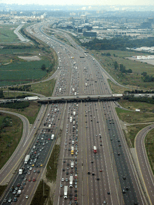
Highway 401 south of Pearson Airport is the widest freeway in Canada, and one of the widest and busiest in the world
-

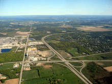
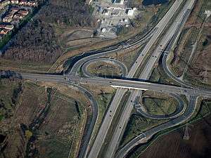
Aerial view of the interchange between Highway 401, 403 and 410 in Mississauga
-
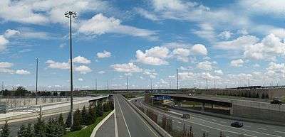
An aerial view of Highway 416 approaching Ottawa
-
A sprawling interchange between Highway 409 and 427 in Etobicoke, one of several in the Greater Toronto Area
-
The Parclo interchange design is used throughout the 400-series network
See also
- Highways in Ontario
- List of Ontario expressways
- 100-Series Highways of Nova Scotia
- Quebec Autoroutes
References
Sources
- 1 2 Ministry of Transportation of Ontario (2010). "Annual Average Daily Traffic (AADT) counts". Government of Ontario. Retrieved March 29, 2016.
- 1 2 3 Walter, Karena (February 21, 2014). "Search Engine: Highway Mysteries Solved". The Niagara Falls Review. Retrieved December 17, 2015.
- ↑ Robins, C.P. (1952). Ontario Road Map (Map). Ontario Department of Highways. § Q28–U41.
- ↑ "Hopes to Improve Roads". The Gazette. Montreal. February 18, 1936. p. 14. Retrieved February 9, 2010.
- ↑ Stamp (1987), pp. 11–12.
- ↑ English, Bob (March 16, 2006). "Remember That 'Little Four-Lane Freeway?'". The Globe And Mail. Toronto.
...the freeway concept was promoted by Hamiltonian Thomas B. McQuesten, then the highway minister. The Queen Elizabeth Way was already under construction, but McQuesten changed it into a dual-lane divided highway, based on Germany's new autobahns.
- ↑ Stamp, Robert M. (1987). The Queen Elizabeth Way, Canada's First Superhighway. Boston Mills Press. ISBN 0-919783-84-8.
- 1 2 3 4 Shragge, John G. (2007). "Highway 401: The Story". Archived from the original on March 28, 2008. Retrieved February 12, 2010.
- 1 2 Built Heritage, Cultural Landscape and Planning Section (January 2006). "2.0 Background History". Heritage Impact Assessment: Christina Street Bridge over Highway 402, Sarnia (PDF) (Report). Archaeological Services Inc. p. 4. Retrieved January 6, 2014.
- ↑ Ministry of Transportation and Communications (1972), pp. 8–9.
- ↑ "Open 400 Link to Coldwater". The Toronto Star. December 24, 1959. p. 18.
The new, 22-mile extension from south of Crown Hill to Coldwater will be ready for traffic this afternoon.
- ↑ Highway Construction Program: King's and Secondary Highways. Ministry of Transportation and Communications. 1972–1973. p. xi.
- ↑ Annual Report (Construction ed.). Ministry of Transportation and Communications. 1982–1983. p. 76.
- ↑ Annual Report for the Fiscal Year (Report). Ontario Department of Highways. March 31, 1958. Retrieved July 25, 2010.
- ↑ Don Valley Parkway Extension, Highway 401 to Steeles Avenue (Report). Desjardines. 1957.
- ↑ "Above the Regular Budget". The Ottawa Citizen. July 31, 1958. p. 7. Retrieved October 20, 2010.
- ↑ Annual Report. Department of Highways. March 31, 1961. Retrieved July 29, 2011.
- 1 2 3 Sewell, John (2009). The Shape of the Suburbs: Understanding Toronto's Sprawl. University of Toronto Press. p. 72. ISBN 978-0-8020-9884-9. Retrieved July 1, 2010.
- ↑ Hicks, Kathleen A. (2006). "Road Controversy - 1968". Malton: Farms to Flying (PDF). Friends of the Mississauga Library System. pp. 208–209. ISBN 0-9697873-9-1. Retrieved April 4, 2010.
- ↑ Robertson, Peter. "The Queensway Began with a Royal Blast: Flashback to 1957.". Carlington Community Association. Archived from the original on April 26, 2012. Retrieved December 17, 2015.
- 1 2 Ontario Department of Highways (1970), p. 11
- 1 2 Construction Program: King's and Secondary Highways (Report). Ministry of Transportation and Communications. 1976–77. p. XV.
- ↑ Ontario Department of Highways (1970), p. 12
- 1 2 Settlement of Claim of Richard Prendiville (PDF) (Report). Ontario Superior Court of Justice. December 12, 2001. p. 7. Archived from the original (PDF) on July 27, 2014. Retrieved December 17, 2015.
- ↑ Construction Program: King's and Secondary Highways (Report). Ministry of Transportation and Communications. 1976–77. p. XIV.
- 1 2 Clark, Glenn (April 14, 2012). A Historical Timeline for the Township of Gloucester. The Gloucester Historical Society. Retrieved July 1, 2012.
- 1 2 "Highway 27 Interchange Fully in Service". The Globe and Mail. Toronto. December 4, 1971. p. 5.
- ↑ Coleman, Thomas (July 12, 1975). "Drivers Will Wait Years Before Relief from QEW Jams". The Globe and Mail. Toronto. p. 5.
- ↑ The History of Toronto's Unfinished Expressway System (Report). Energy Probe. April 5, 2009. Retrieved January 23, 2012.
- ↑ "New 45-Mile Highway to Link Ottawa with 401". The Globe and Mail. Toronto. November 14, 1967. p. 4.
- ↑ "Queen Elizabeth Way - Hamilton to Fort Erie". Highway Construction Program 1972-73 (Report). Ministry of Transportation and Communications. April 1972. p. xv.
- ↑ Stamp, Robert M. (1992). Bridging the Border: Structures of Canadian–American Relations. Toronto: Dundurn Press. p. 129. ISBN 1-55002-074-9.
- ↑ Stamp (1987), pp. 59–61.
- ↑ "Chronology". Annual Report (Report). Department of Highways. March 31, 1964. p. 296.
- ↑ Cartography Section (1986). Ontario Road Map (Map). Ministry of Transportation and Communications.
- 1 2 Cartography Section (2014–15). Ontario Road Map (Map). Ministry of Transportation of Ontario.
- ↑ Ministry of Transportation of Ontario (May 2000). "Highway 69 Four-Laning Port Severn to Parry Sound" (PDF). Government of Ontario. Retrieved December 27, 2011.
- ↑ Transportation Capital Branch (1991–1992). Provincial Highways Construction Projects. Ministry of Transportation. p. 7. ISSN 0714-1149.
- ↑ Dexter, Brian (October 25, 1989). "Ontario Studies Plan to Extend Highway 404 Farther North". News. The Toronto Star. p. A8.
- ↑ Provincial Highways Construction Projects (Report). Ministry of Transportation. 1989–90. p. 13. ISSN 0714-1149.
- ↑ Transportation Capital Branch (May 1991). Northern Transportation Construction Projects 1988–89 (Report). Ministry of Transportation of Ontario. p. 16. ISSN 0714-1149.
- ↑ Transportation Capital Branch (1986–1987). Provincial Highways Construction Projects. Ministry of Transportation and Communications. p. XII. ISSN 0714-1149.
- ↑ "Ottawa Highway Link Opens". Ontario. Toronto Star. Canadian Press. September 24, 1999. p. A4.
- ↑ Abrey, Heather (November 20, 2009). "Hwy 410 Extension Causing Confusion". Caledon Enterprise. North Peel Media Group. Retrieved December 17, 2015.
- ↑ Ginn, Cameron (October 27, 2010). "$177-Million Section of Highway Now Open". Cottage Country Now. Metroland Media Group. Retrieved December 17, 2015.
- ↑ Chase, Sean (November 30, 2012). "Highway 417 opens at Arnprior". The Pembroke Observer. Canoe Sun Media. Retrieved December 2, 2012.
- ↑ Bradley, Dave (September 17, 2014). "Highway 404 Extension Opens". NewsTalk 1010. Retrieved September 17, 2014.
- ↑ "Newsroom: Highway 401 Section of the New Rt. Hon. Herb Gray Parkway Now Complete". News.Ontario.ca. Ministry of Transportation. November 20, 2015. Retrieved November 21, 2015.
- ↑ Forsyth, Paul (August 19, 2011). "406 Widening Underway". Niagara This Week. Metroland Media. Retrieved December 17, 2015.
- ↑ Revie, Nancy (September 19, 2005). "An Expressway in Name Only". The Guelph Mercury. p. A9.
- ↑ Proceedings ... Annual Meeting (Report). Institute of Traffic Engineers. 1962. pp. 100–103.
- ↑ "Partial Cloverleaf Interchange (Parclo)". The Canadian Design Resource. Retrieved June 4, 2015.
- ↑ Road Safety Policy Office - Vehicles (2010). "Forward" (PDF). Ontario Road Safety Annual Report. Government of Ontario. p. 7. ISSN 1710-2480. Archived from the original (PDF) on April 15, 2014. Retrieved December 17, 2015.
- 1 2 Ministry of Transportation of Ontario (May 2010). "Ontario Traffic Manual Book 8: Guide and Information Signs – Volume 1" (PDF). Government of Ontario. p. 53. Retrieved February 24, 2016.
- ↑ Ministry of Tourism, Culture and Sport (November 23, 2015). "Tourism-Oriented Directional Signing (TODS) Program". Government of Ontario. Retrieved February 24, 2016.
- ↑ Ministry of Northern Development and Mines (June 2005). Highway 69 Action Plan (PDF) (Report). Government of Ontario. p. 3. Retrieved February 25, 2016.
- ↑ "Highway Traffic Act". Government of Ontario. 2016. Retrieved May 8, 2016.
- ↑ Nikolic, Goran; Pringle, Rob (2008). Evaluating HOV Plans and Priorities – the Case of Expressways in the GTA (PDF) (Report). Transportation Association of Canada. pp. 2–4. Retrieved January 1, 2016.
- 1 2 Ministry of Transportation of Ontario (May 24, 2015). "McGuinty Government To Improve Commuters Lives With HOV Lane Network" (Press release). CNW Group. Retrieved January 1, 2016.
- 1 2 3 Ministry of Transportation of Ontario. "Ontario's High Occupancy Vehicle Lane Network Plan for the 400-Series Highways in the Greater Golden Horseshoe". Government of Ontario. Archived from the original on October 18, 2014. Retrieved June 9, 2015.
- ↑ "The Big Move - Strategy #3 - Improve the Efficiency of the Road and Highway Network". Metrolinx. Retrieved June 9, 2015.
- ↑ Shum, David (June 29, 2015). "HOV Lane Restrictions Now in Effect for Pan Am Games". Global News. Retrieved August 22, 2015.
- 1 2 3 Shragge & Bagnato (1984), pp. 89–92.
- ↑ Maier, Hanna (October 9, 2007). "Chapter 2". Long-Life Concrete Pavements in Europe and Canada (Report). Federal Highway Administration. Retrieved May 1, 2010.
The key high-volume highways in Ontario are the 400-series highways in the southern part of the province. The most important of these is the 401, the busiest highway in North America, with average annual daily traffic (AADT) of more than 425,000 vehicles in 2004 and daily traffic sometimes exceeding 500,000 vehicles.
- 1 2 Ontario Department of Highways (1970), p. 11.
- ↑ Ontario Department of Highways (1970), p. 12.
- ↑ Mitchell, Bob (June 6, 1997). "At Last — Opening Bell Tolls for the 407". The Toronto Star. pp. A1, A6.
- ↑ "Map / Toll Calculator". 407 ETR. February 1, 2014. Retrieved December 17, 2015.
- ↑ "New Shortcut Will Let Some 'Fly' to Airport". Metro News. The Toronto Star. August 19, 1978. p. A6.
Highway 409, a new shortcut to Toronto International Airport, opens next Friday
- ↑ Public and Safety Information Section (November 9, 1978). "Highway 410 Opens November 15" (Press release). Ministry of Transportation and Communications.
- ↑ Pessian, Parvaneh (June 17, 2016). "UPDATE: Hwy. 407 From Pickering to Oshawa Opens June 20: Toll Free Until End of 2016". Whitby This Week. Retrieved June 17, 2016.
- 1 2 "New Highway Numbers". Highway 407 East. Retrieved February 10, 2015.
- ↑ "Ottawa Highway Link Opens". Ontario. Toronto Star. Canadian Press. September 24, 1999. p. A4.
- ↑ Stamp (1992), pp. 124–127.
- ↑ Shragge & Bagnato (1984), pp. 79–81.
Bibliography
- Shragge, John; Bagnato, Sharon (1984). From Footpaths to Freeways. Ontario Ministry of Transportation and Communications, Historical Committee. ISBN 0-7743-9388-2.
- Stamp, Robert M. (1987). QEW: Canada's First Superhighway. The Boston Mills Press. ISBN 0-919783-84-8.
- '401' The Macdonald–Cartier Freeway. Toronto: Ministry of Transportation and Communications. 1972.
- AADT Traffic Volumes 1955–1969 and Traffic Collision Data 1967–1969. Ontario Department of Highways. 1970.
External links
| Wikimedia Commons has media related to 400-series highways. |
- Ontario Ministry of Transportation
- Highway Construction Programs
- Photographs and history on the 400-Series Highways (and other provincial highways, too)