38th parallel north

38°
38th parallel north
38th parallel north
Hangul 삼팔선
Hanja 三八線
Revised Romanization Sampalseon
McCune–Reischauer Samp'alsŏn

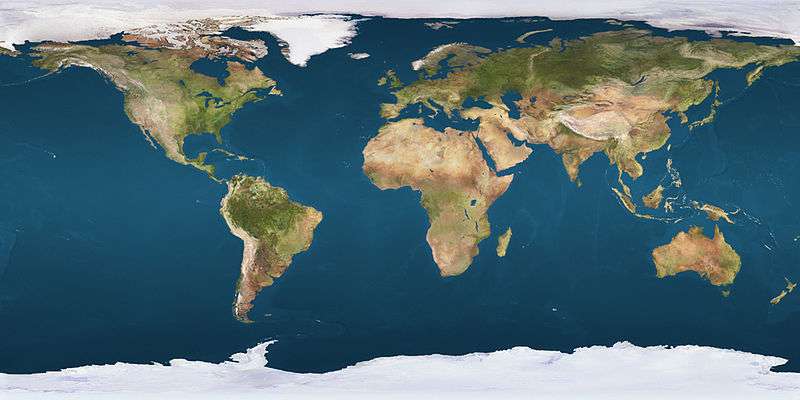
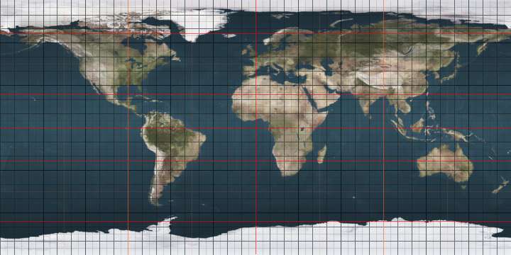
The 38th parallel north is a circle of latitude that is 38 degrees north of the Earth's equatorial plane. It crosses Europe, the Mediterranean Sea, Asia, the Pacific Ocean, North America, and the Atlantic Ocean. The 38th parallel north formed the border between North and South Korea prior to the Korean War.

At this latitude the sun is visible for 14 hours, 48 minutes during the summer solstice and 9 hours, 32 minutes during the winter solstice.[1]

Around the world

Starting at the Prime Meridian heading eastwards, the 38th parallel north passes through:

Co-ordinates Country, territory or sea Notes
38°0′N 0°0′E / 38.000°N 0.000°E / 38.000; 0.000 (Prime Meridian) Mediterranean Sea Passing just north of the island of Marettimo,  Italy (at 37°59′43″N 12°1′47″E / 37.99528°N 12.02972°E / 37.99528; 12.02972 (Marettimo))
38°0′N 12°19′E / 38.000°N 12.317°E / 38.000; 12.317 (Italy)  Italy Islands of Levanzo and Sicily
38°0′N 15°25′E / 38.000°N 15.417°E / 38.000; 15.417 (Mediterranean Sea) Mediterranean Sea Strait of Messina
38°0′N 15°38′E / 38.000°N 15.633°E / 38.000; 15.633 (Italy)  Italy Passing through Reggio di Calabria (southern suburbs)
38°0′N 16°8′E / 38.000°N 16.133°E / 38.000; 16.133 (Mediterranean Sea) Mediterranean Sea Ionian Sea - passing between the islands of Kefalonia (at 38°4′N 20°43′E / 38.067°N 20.717°E / 38.067; 20.717 (Kefalonia)) and Zakynthos (at 37°56′N 20°42′E / 37.933°N 20.700°E / 37.933; 20.700 (Zakynthos)),  Greece
38°0′N 21°16′E / 38.000°N 21.267°E / 38.000; 21.267 (Greece)  Greece Passing through Athens (northern suburbs)
38°0′N 24°2′E / 38.000°N 24.033°E / 38.000; 24.033 (Aegean Sea) Aegean Sea
38°0′N 24°14′E / 38.000°N 24.233°E / 38.000; 24.233 (Greece)  Greece Islands of Petalioi and Euboea
38°0′N 24°34′E / 38.000°N 24.567°E / 38.000; 24.567 (Aegean Sea) Aegean Sea Passing just north of the island of Andros (at 37°59′57″N 24°47′23″E / 37.99917°N 24.78972°E / 37.99917; 24.78972 (Andros)),  Greece
38°0′N 27°7′E / 38.000°N 27.117°E / 38.000; 27.117 (Turkey)  Turkey
38°0′N 44°17′E / 38.000°N 44.283°E / 38.000; 44.283 (Iran)  Iran
38°0′N 48°55′E / 38.000°N 48.917°E / 38.000; 48.917 (Caspian Sea) Caspian Sea
38°0′N 53°49′E / 38.000°N 53.817°E / 38.000; 53.817 (Turkmenistan)  Turkmenistan
38°0′N 55°17′E / 38.000°N 55.283°E / 38.000; 55.283 (Iran)  Iran
38°0′N 57°22′E / 38.000°N 57.367°E / 38.000; 57.367 (Turkmenistan)  Turkmenistan Passing just north of Ashgabat
38°0′N 66°38′E / 38.000°N 66.633°E / 38.000; 66.633 (Uzbekistan)  Uzbekistan
38°0′N 68°17′E / 38.000°N 68.283°E / 38.000; 68.283 (Tajikistan)  Tajikistan
38°0′N 70°19′E / 38.000°N 70.317°E / 38.000; 70.317 (Afghanistan)  Afghanistan
38°0′N 71°16′E / 38.000°N 71.267°E / 38.000; 71.267 (Tajikistan)  Tajikistan
38°0′N 74°54′E / 38.000°N 74.900°E / 38.000; 74.900 (China)  People's Republic of China Xinjiang
Qinghai
Gansu
Inner Mongolia
Ningxia
Inner Mongolia
Shaanxi − for around 5 km
Inner Mongolia − for around 14 km
Shaanxi
Shanxi — passing just north of Taiyuan
Hebei — passing just south of Shijiazhuang
Shandong
38°0′N 118°58′E / 38.000°N 118.967°E / 38.000; 118.967 (Yellow Sea) Yellow Sea Passing just north of Baengnyeong Island (at 37°59′N 124°41′E / 37.983°N 124.683°E / 37.983; 124.683 (Baengnyeong)),  South Korea
38°0′N 125°7′E / 38.000°N 125.117°E / 38.000; 125.117 (North Korea)  North Korea Ongjin PeninsulaSouth Hwanghae Province
38°0′N 125°35′E / 38.000°N 125.583°E / 38.000; 125.583 (Yellow Sea) Yellow Sea Ongjin Bay
38°0′N 125°46′E / 38.000°N 125.767°E / 38.000; 125.767 (North Korea)  North Korea South Hwanghae Province
North Hwanghae Province
passing just north of Kaesong
38°0′N 126°49′E / 38.000°N 126.817°E / 38.000; 126.817 (South Korea)  South Korea Gyeonggi Province- Passing through Paju, Yeoncheon County, Pocheon, Gapyeong County
Gangwon Province - Passing through Hwacheon County, Chuncheon, Inje County, Yangyang County
38°0′N 128°44′E / 38.000°N 128.733°E / 38.000; 128.733 (Sea of Japan) Sea of Japan
38°0′N 138°14′E / 38.000°N 138.233°E / 38.000; 138.233 (Japan)  Japan Island of Sado:
Niigata Prefecture
38°0′N 138°33′E / 38.000°N 138.550°E / 38.000; 138.550 (Sea of Japan) Sea of Japan
38°0′N 139°14′E / 38.000°N 139.233°E / 38.000; 139.233 (Japan)  Japan Island of Honshū:
— Niigata Prefecture
Yamagata Prefecture
Miyagi Prefecture
38°0′N 140°55′E / 38.000°N 140.917°E / 38.000; 140.917 (Pacific Ocean) Pacific Ocean
38°0′N 123°1′W / 38.000°N 123.017°W / 38.000; -123.017 (United States)  United States California
Nevada
Utah
Colorado
Kansas
Missouri
Illinois
Indiana
Kentucky
West Virginia
Virginia
38°0′N 76°28′W / 38.000°N 76.467°W / 38.000; -76.467 (Chesapeake Bay) Chesapeake Bay
38°0′N 75°53′W / 38.000°N 75.883°W / 38.000; -75.883 (United States)  United States Maryland
Virginia
38°0′N 75°16′W / 38.000°N 75.267°W / 38.000; -75.267 (Pacific Ocean) Atlantic Ocean Passing between Pico (at 38°23′N 28°14′W / 38.383°N 28.233°W / 38.383; -28.233 (Pico)) and São Miguel (at 37°55′N 25°47′W / 37.917°N 25.783°W / 37.917; -25.783 (São Miguel)) islands, Azores,  Portugal
38°0′N 8°51′W / 38.000°N 8.850°W / 38.000; -8.850 (Portugal)  Portugal Setúbal District
Beja District - passing just south of Beja
38°0′N 7°12′W / 38.000°N 7.200°W / 38.000; -7.200 (Spain)  Spain Andalusia
Extremadura
Andalusia
Region of Murcia - passing just north of Murcia
Valencian Community
38°0′N 0°39′W / 38.000°N 0.650°W / 38.000; -0.650 (Mediterranean Sea) Mediterranean Sea

Korea

The land on the left side of the boundary in this picture belongs to South Korea while on the right side it belongs to North Korea.

When Japan surrendered in August 1945, the 38th parallel was established as the boundary between Soviet and American occupation zones. This parallel divides the Korean peninsula roughly in the middle. In 1948, this parallel became the boundary between the Democratic People's Republic of Korea (North Korea) and the Republic of Korea (South Korea), both of which claim to be the government of the whole of Korea. On 25 June 1950, after a series of cross-border raids and gunfire from both the Northern and the Southern sides, the North Korean Army crossed the parallel and invaded South Korea. This sparked a United Nations resolution against the aggression and the Korean War, with United Nations troops (mostly Americans) helping to defend South Korea.[2]

After the Armistice ended the Korean War in 1953, a new border was established based on the territory that each side held at that point. This Military Demarcation Line is surrounded by a Demilitarized Zone. It crosses the 38th parallel, from the southwest to the northeast. The new border is still often described as the 38th parallel, but this is not accurate.

See also

References

  1. http://aa.usno.navy.mil/data/docs/Dur_OneYear.php
  2. Nash, Gary B., The American People (6th edition), Pearson Longman (New York), 2008.

Further reading

This article is issued from Wikipedia - version of the 8/29/2016. The text is available under the Creative Commons Attribution/Share Alike but additional terms may apply for the media files.