36th parallel north

36°
36th parallel north

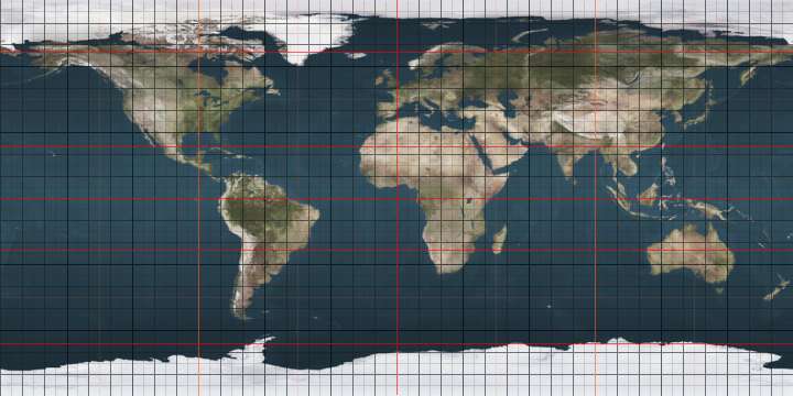
The 36th parallel north is a circle of latitude that is 36 degrees north of the Earth's equatorial plane. It crosses Africa, the Mediterranean Sea, Asia, the Pacific Ocean, North America and the Atlantic Ocean.

From 7 April 1991 to 31 December 1996, the parallel defined the limit of the northern no-fly zone in Iraq.[1]

At this latitude the sun is visible for 14 hours, 36 minutes during the summer solstice and 9 hours, 43 minutes during the winter solstice.[2]

Around the world

Starting at the Prime Meridian and heading eastwards, the parallel 36° north passes through:

Co-ordinates Country, territory or sea Notes
36°0′N 0°0′E / 36.000°N 0.000°E / 36.000; 0.000 (Prime Meridian) Mediterranean Sea
36°0′N 0°7′E / 36.000°N 0.117°E / 36.000; 0.117 (Algeria)  Algeria
36°0′N 8°18′E / 36.000°N 8.300°E / 36.000; 8.300 (Tunisia)  Tunisia
36°0′N 10°31′E / 36.000°N 10.517°E / 36.000; 10.517 (Mediterranean Sea) Mediterranean Sea Passing just north of the island of Linosa,  Italy
Passing between the islands of Comino and Malta,  Malta
36°0′N 23°10′E / 36.000°N 23.167°E / 36.000; 23.167 (Aegean Sea) Aegean Sea Passing between the islands of Kythira and Antikythera,  Greece
Passing just north of Saria Island,  Greece
36°0′N 27°45′E / 36.000°N 27.750°E / 36.000; 27.750 (Greece)  Greece Island of Rhodes
36°0′N 27°55′E / 36.000°N 27.917°E / 36.000; 27.917 (Mediterranean Sea) Mediterranean Sea
36°0′N 35°59′E / 36.000°N 35.983°E / 36.000; 35.983 (Turkey)  Turkey Hatay Province
36°0′N 36°22′E / 36.000°N 36.367°E / 36.000; 36.367 (Syria)  Syria
36°0′N 41°17′E / 36.000°N 41.283°E / 36.000; 41.283 (Iraq)  Iraq
36°0′N 45°21′E / 36.000°N 45.350°E / 36.000; 45.350 (Iran)  Iran
36°0′N 61°10′E / 36.000°N 61.167°E / 36.000; 61.167 (Turkmenistan)  Turkmenistan
36°0′N 63°49′E / 36.000°N 63.817°E / 36.000; 63.817 (Afghanistan)  Afghanistan
36°0′N 71°15′E / 36.000°N 71.250°E / 36.000; 71.250 (Pakistan)  Pakistan Khyber Pakhtunkhwa
Gilgit-Baltistan - claimed by  India
36°0′N 76°6′E / 36.000°N 76.100°E / 36.000; 76.100 (Shaksgam Valley) Shaksgam Valley Area administered by  People's Republic of China, claimed by  India
36°0′N 76°48′E / 36.000°N 76.800°E / 36.000; 76.800 (China)  People's Republic of China Xinjiang
Tibet
Qinghai
Gansu — passing just south of Lanzhou
Ningxia
Gansu
Shaanxi
Shanxi
Henan
Shandong
Henan (for about 15 km)
Shandong — passing just south of Qingdao
36°0′N 120°18′E / 36.000°N 120.300°E / 36.000; 120.300 (Yellow Sea) Yellow Sea
36°0′N 126°42′E / 36.000°N 126.700°E / 36.000; 126.700 (South Korea)  South Korea South Chungcheong Province
North Jeolla Province
North Gyeongsang Province
passing just north of Daegu-Palgong Mountain
North Gyeongsang Province
36°0′N 129°35′E / 36.000°N 129.583°E / 36.000; 129.583 (Sea of Japan) Sea of Japan
36°0′N 133°1′E / 36.000°N 133.017°E / 36.000; 133.017 (Japan)  Japan Island of Chiburi-shima:
Shimane Prefecture
36°0′N 133°4′E / 36.000°N 133.067°E / 36.000; 133.067 (Sea of Japan) Sea of Japan
36°0′N 135°58′E / 36.000°N 135.967°E / 36.000; 135.967 (Japan)  Japan Island of Honshū:
Fukui Prefecture
Gifu Prefecture
Nagano Prefecture
Gunma Prefecture for about 4 km
Saitama Prefecture
Chiba Prefecture for about 6 km
Ibaraki Prefecture
36°0′N 140°40′E / 36.000°N 140.667°E / 36.000; 140.667 (Pacific Ocean) Pacific Ocean
36°0′N 121°30′W / 36.000°N 121.500°W / 36.000; -121.500 (United States)  United States California
Nevada
Arizona
New Mexico
Texas
Oklahoma
Arkansas
Missouri / Arkansas border (approximate)
Tennessee
North Carolina (Madison County, for about 14 km)
Tennessee (Unicoi County, for about 12 km)
North Carolina
36°0′N 75°39′W / 36.000°N 75.650°W / 36.000; -75.650 (Atlantic Ocean) Atlantic Ocean
36°0′N 5°36′W / 36.000°N 5.600°W / 36.000; -5.600 (Strait of Gibraltar) Strait of Gibraltar Passing a few metres south of Punta de Tarifa,  Spain - the most southerly point of the European mainland
36°0′N 5°25′W / 36.000°N 5.417°W / 36.000; -5.417 (Mediterranean Sea) Mediterranean Sea

United States

In the United States, the 36th parallel north is occasionally used as a rough northern boundary for the Sun Belt, a region spanning most Southern and Southwestern states and comprising most of the nation's warmest climates.

Cities and landmarks close to the parallel include the following: Kettleman City, California; Henderson, Nevada; Hoover Dam; South Rim of the Grand Canyon; Los Alamos National Laboratory; Tulsa, Oklahoma; Nashville, Tennessee; Knoxville, Tennessee; Winston-Salem, North Carolina; High Point, North Carolina; Greensboro, North Carolina; Durham, North Carolina; Chapel Hill, North Carolina; and others.

The sixth standard parallel south of Mount Diablo Range at 35°48′ north, 13.8344 miles south of the 36th parallel, forms a continuous boundary between the California counties of Monterey, Kings, Tulare, and Inyo on the north and the counties of San Luis Obispo, Kern, and San Bernardino on the south.[3] It is sometimes taken as the boundary between Northern California and Southern California,[4] although definitions using the Tehachapi Mountains are also common.

The parallel 36° north approximately forms the southernmost boundary of the Missouri Bootheel with the State of Arkansas.

The 36th parallel passes through Duke University in several places. Its Campus Drive that connects the campuses crosses the parallel several times. The Duke Gardens has a "36th Parallel Club" although the garden itself is just north of the parallel.

References

  1. "Containment: The Iraqi no-fly zones". BBC News. 29 December 1998. Retrieved 4 February 2012.
  2. "Duration of Daylight/Darkness Table for One Year". aa.usno.navy.mil. Retrieved 2016-04-10.
  3. California (1886-01-01). The Codes and Statutes of California, as Amended and in Force at the Close of the Twenty-sixth Session of the Legislature, 1885: With Notes Containing References to All the Decisions of the Supreme Court Construing Or Illustrating the Sections of the Codes, and to Adjudications of the Courts of Other States Having Like Code Provisions. A. L. Bancroft.
  4. California, Historical Society of Southern; California, Los Angeles County Pioneers of Southern (1901-01-01). The Quarterly.

See also

This article is issued from Wikipedia - version of the 11/15/2016. The text is available under the Creative Commons Attribution/Share Alike but additional terms may apply for the media files.