1976 Guatemala earthquake
 | |
 | |
| Date | February 4, 1976 |
|---|---|
| Origin time | 09:01:43 UTC-6 |
| Magnitude | 7.5 Mw |
| Depth | 5 kilometres (3 mi) |
| Epicenter | 15°19′N 89°06′W / 15.32°N 89.10°WCoordinates: 15°19′N 89°06′W / 15.32°N 89.10°W |
| Type | Strike-slip |
| Areas affected | Guatemala |
| Max. intensity | IX (Violent) [1] |
| Casualties | 23,000 fatalities, 76,000 injured |
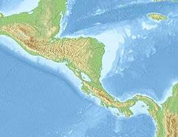
The 1976 Guatemala earthquake struck on February 4 at 03:01:43 local time with a moment magnitude of 7.5. The shock was centered on the Motagua Fault, about 160 km northeast of Guatemala City at a depth of 5 kilometers (3.1 mi) near the town of Los Amates in the department of Izabal.[1]
Cities throughout the country suffered damage, and most adobe type houses in the outlying areas of Guatemala City were destroyed. The earthquake struck during the early morning (at 3:01 am, local time) when most people were asleep. This contributed to the high death toll of 23,000. Approximately 76,000 were injured, and many thousands left homeless. Some of areas went without electricity and communications for days.
The main shock was followed by thousands of aftershocks, some of the larger ones causing additional damage and loss of life.[2]
Seismic data
The quake's epicentre was located near the town of Los Amates, in the eastern part of the Motagua Fault, a left-lateral strike-slip fault that forms the tectonic boundary between the North American plate and the Caribbean plate.[1] Ground shaking was felt during approximately 39 seconds, and caused visible rupturing over 230 km along the Motagua fault, while the inferred length of faulting—based on aftershock registration—was estimated at 300 km. Average horizontal displacement along the Motagua fault was 100 cm, with a maximum displacement of 326 cm.[1]
Maximum seismic intensity (MM IX) was located in the Mixco area, some sections of Guatemala City and in Gualán. A seismic intensity of MM VI covered an area of 33,000 km².[1] Liquefaction and sand boils were observed in several locations with high seismic intensity. The main quake activated secondary fault zones, including the Mixco fault, located in a densely populated area just north-west of Guatemala City.
Victims and damage
The most heavily affected area covered some 30,000 km², with a population of 2.5 million. Some 23,000 people were reported dead and 77,000 wounded. Approximately 258,000 houses were destroyed, leaving about 1.2 million people homeless. 40% of the national hospital infrastructure was destroyed, while other health facilities also suffered substantial damage.[3]
International reaction
Very soon after the earthquake, the then president Kjell Eugenio Laugerud García invited most of the foreign ambassadors to tour the affected regions by helicopter, which prompted them to quickly ask for help in their home countries. For example, the United States of America rebuilt most of the roads, and the Canadians and Belgians each rebuilt a village.
Aftershocks
Several heavy aftershocks, ranging from 5.2 to 5.8 Mw caused additional casualties and hampered relief efforts.
| Date | Origin Time | Coordinates | Location | Depth | Magnitude |
| Feb. 04 1976 | 09.30.28.3 | 14°42′N 90°36′W / 14.7°N 90.6°W | 7 km NNE of Mixco | 5 km | 5.8 Mw |
| Feb. 06 1976 | 04.11.03.3 | 14°36′N 91°06′W / 14.6°N 91.1°W | 6 km SSE of San Lucas Tolimán | 5 km | 4.8 Mw |
| Feb. 06 1976 | 18.11.59.2 | 14°18′N 90°12′W / 14.3°N 90.2°W | 11 km ENE of Cuilapa | 5 km | 5.2 Mw |
| Feb. 06 1976 | 18.19.17.7 | 14°42′N 90°36′W / 14.7°N 90.6°W | 5 km ENE of San Pedro Sacatepéquez | 5 km | 5.8 Mw |
| Feb. 08 1976 | 08.13.51.9 | 15°42′N 88°30′W / 15.7°N 88.5°W | 13 km SE of Puerto Barrios | 5 km | 5.7 Mw |
| Feb. 09 1976 | 11.44.46.7 | 15°18′N 89°06′W / 15.3°N 89.1°W | 30 km WSW of Morales | 5 km | 5.1 Mw |
| Feb. 10 1976 | 06.17.43.0 | 15°00′N 89°42′W / 15.0°N 89.7°W | 18 km WNW of Zacapa | 5 km | 4.7 Mw |
| Mar. 07 1976 | 02.54.05.4 | 14°54′N 90°54′W / 14.9°N 90.9°W | 14.5 km SW of Joyabaj | 5 km | 4.8 Mw |
| Mar. 07 1976 | 03.15.40.3 | 14°42′N 90°30′W / 14.7°N 90.5°W | Chinautla (9 km North of Guatemala City) | 5 km | 4.9 Mw |
Image gallery
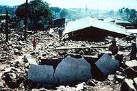
- Guatemala City
-
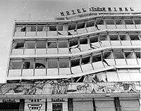
Hotel Terminal
-
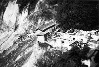
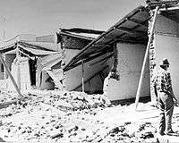
Landslide in Guatemala City
-
Guatemala City centre
- Antigua Guatemala
-
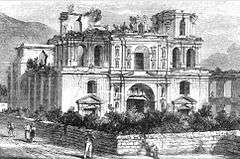
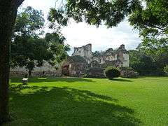
Society of Jesus church ruins in 1896.
-
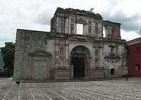
Jesuit church façade, stabilized in the 21st century. Note the damage to the structure after the 1976 earthquake.
-
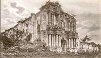
"Nuestra Señora del Carmen" church en 1896.
-
.jpg)
Same church in 2010, after the 1976 earthquake.
-
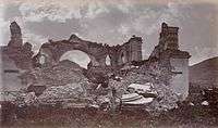
Iglesia de La Recolección in 1875. The only surviving arch was a symbol of Antigua Guatemala ruins for many years.
-
La Recolección in 2005. The 1917 and 1976 earthquakes destroyed what was left of the iconic arch.
- Rural Guatemala
-
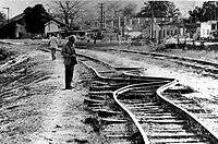
Bent rails in Gualán
-
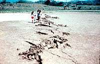
Motagua Fault in Gualán
-
Patzicía destroyed
Notes
- 1 2 3 4 5 NOAA database
- ↑ Historic Earthquakes
- ↑ Olcese (e.a.), 1977
References
- Bates, F.L.; Killian, C.D.; Daniel G.R. & Klein, R.E. (1979). "Emergency Food Programmes following the 1976 Guatemalan Earthquake: An Evaluation: Final Report" (PDF). Washington: USAID.
- Bucknam, R.C.; Plafker, George; Sharp, R.V. (March 1978). "Fault movement (afterslip) following the Guatemala earthquake of February 4, 1976". Geology. 6 (3): 170–173. Bibcode:1978Geo.....6..170B. doi:10.1130/0091-7613(1978)6<170:FMAFTG>2.0.CO;2.
- Langer, C.V.; G.A. Bollinger. "Secondary faulting near the terminus of a seismogenic strike-slip fault: aftershocks of the 1976 Guatemala earthquake". Bulletin of the Seismological Society of America. Seismological Society of America. 69 (2): 427–444.
- Matumoto, Tosimatu; Latham, Gary V. "Aftershocks of the Guatemalan earthquake of February 4, 1976". Geophysical Research Letters. 3 (10): 599–602. Bibcode:1976GeoRL...3..599M. doi:10.1029/GL003i010p00599.
- Olcese, Orlando; Ramón Moreno & Francisco Ibarra (July 1977). "The Guatemala Earthquake Disaster of 1976: A Review of its Effects and of the contribution of the United Nations family". UNDP, Guatemala.
- Olson, Robert A.; Richard Stuart Olson (1977). "The Guatemala earthquake of 4 February 1976: Social science observations and research suggestions" (PDF). Mass Emergencies: 69–81.
- Plafker, G. (1976). "Tectonic aspects of the Guatemala earthquake of 4 February 1976". Science. American Association for the Advancement of Science. 193 (4259): 1201–1208. Bibcode:1976Sci...193.1201P. doi:10.1126/science.193.4259.1201. PMID 17837005.
- Plafker, G.; M.G. Bonilla & S.B. Bonis (1976). "Geologic effects in the Guatemala Earthquake of February 4, 1976, a preliminary Report. Professional Paper 1002". Washington: USGS: 38–51.
- USGS (May–June 1976). "Guatemalan Quake Culprit Fault Identified". Earthquake Information Bulletin. USGS. 8 (3).
- Young, Christopher J.; Thorne Lay & Christopher S. Lynnes (June 1989). "Rupture of the 4 February 1976 Guatemalan earthquake". Bulletin of the Seismological Society of America. Seismological Society of America. 79 (3): 670–689.
External links
| Wikimedia Commons has media related to 1976 Guatemala earthquake. |
Guatemala articles | |||||||
|---|---|---|---|---|---|---|---|
| History |  | ||||||
| Geography |
| ||||||
| Politics | |||||||
| Economy | |||||||
| Society |
| ||||||
| |||||||