1928 Okeechobee hurricane
| Category 5 major hurricane (SSHWS/NWS) | |
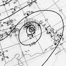 Surface weather analysis of the storm nearing Puerto Rico | |
| Formed | September 6, 1928 |
|---|---|
| Dissipated | September 20, 1928 |
| Highest winds |
1-minute sustained: 160 mph (260 km/h) |
| Lowest pressure | ≤ 929 mbar (hPa); 27.43 inHg |
| Fatalities | 4,000+ |
| Damage | $100 million (1928 USD) |
| Areas affected | Lesser Antilles, Guadeloupe, Virgin Islands, Puerto Rico, Bahamas, Florida, Georgia, South Carolina, North Carolina, United States East Coast, Atlantic Canada |
| Part of the 1928 Atlantic hurricane season | |
The Okeechobee hurricane, also known as San Felipe Segundo hurricane, was one of the deadliest tropical cyclones in the recorded history of the North Atlantic basin. The fourth tropical cyclone, third hurricane, and only major hurricane of the 1928 season, this system developed just offshore the west coast of Africa on September 6. Initially a tropical depression, it strengthened into a tropical storm later that day, shortly before passing south of the Cape Verde Islands. Further intensification was slow and halted by late on September 7. About 48 hours later, the storm resumed strengthening and became a Category 1 hurricane on the modern-day Saffir–Simpson hurricane wind scale. Still moving westward, the system reached Category 4 intensity before striking Guadeloupe on September 12. There, the storm brought "great destruction" and 1,200 deaths. The islands of Martinique, Montserrat, and Nevis also reported damage and fatalities, but not nearly as severe as in Guadeloupe.
Around midday on September 13, the storm strengthened into a Category 5 hurricane and peaked with sustained winds of 160 mph (260 km/h). About six hours later, the system made landfall in Puerto Rico; it was the only recorded tropical cyclone to strike the island at Category 5 intensity. Very strong winds resulted in severe damage in Puerto Rico. Throughout the island, an estimated 24,728 homes were destroyed and 192,444 were damaged, leaving over 500,000 people homeless. Heavy rainfall also led to extreme damage to vegetation and agriculture. On Puerto Rico alone, there were 312 deaths and about $50 million (1928 USD) in damage. While crossing the island and emerging into the Atlantic, the storm weakened slightly, falling to Category 4 intensity. The storm began crossing through the Bahamas on September 16. Due to preparations, minimal damage or loss of life occurred, with 18 fatalities reported.
Early on September 17, the storm made landfall near West Palm Beach, Florida with winds of 145 mph (233 km/h). In the city, more than 1,711 homes were destroyed. Elsewhere in the county, impact was severest around Lake Okeechobee. The storm surge caused water to pour out of the southern edge of the lake, flooding hundreds of square miles as high as 20 feet (6.1 m) above ground. Numerous houses and buildings were swept away in the cities of Belle Glade, Canal Point, Chosen, Pahokee, and South Bay. At least 2,500 people drowned, while damage was estimated at $25 million. While crossing Florida, the system weakened significantly, falling to Category 1 intensity late on September 17. It curved north-northeastward and briefly re-emerged into the Atlantic on September 18, but soon made another landfall near Edisto Island, South Carolina with winds of 85 mph (140 km/h). Early on the following day, the system weakened to a tropical storm and became extratropical over North Carolina hours later. Overall, the system caused $100 million in damage and at least 4,079 deaths.
Meteorological history
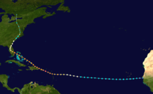
On September 6, ships reported a tropical depression developing just off the west coast of Africa near Dakar, Senegal. The next day, a ship reported winds of 60 mph (95 km/h), or tropical storm status; on this basis, the Atlantic hurricane reanalysis project estimated that the system attained tropical storm status late on September 6. However, lack of observations for several days prevented the system from being classified in real time as it moved generally westward across the Atlantic Ocean.[1] On September 10, the S.S. Commack first observed the storm about 900 miles (1450 km) to the east of Guadeloupe, which at the time was the most easterly report of a tropical cyclone ever received through ship's radio. Later that day, two other ships confirmed the intensity of the storm,[2] and the Hurricane Research Division estimated it strengthened into a hurricane at 18:00 UTC on September 10.[1]
| Rank | Hurricane | Season | Landfall pressure |
|---|---|---|---|
| 1 | "Labor Day" | 1935 | 892 mbar (hPa) |
| 2 | Camille | 1969 | 900 mbar (hPa) |
| 3 | Katrina | 2005 | 920 mbar (hPa) |
| 4 | Andrew | 1992 | 922 mbar (hPa) |
| 5 | "Indianola" | 1886 | 925 mbar (hPa) |
| 6 | "Florida Keys" | 1919 | 927 mbar (hPa) |
| 7 | "Okeechobee" | 1928 | 929 mbar (hPa) |
| 8 | "Great Miami" | 1926 | 930 mbar (hPa) |
| Donna | 1960 | 930 mbar (hPa) | |
| 10 | Carla | 1961 | 931 mbar (hPa) |
| Source: HURDAT,[3] Hurricane Research Division[4] | |||
As the storm neared the Lesser Antilles, it continued to intensify.[3] Between 17:30 and 18:30 UTC on September 12, the hurricane's eye moved over Guadeloupe with a barometric pressure of 940 millibars (28 inHg), suggesting maximum sustained winds of 240 km/h (140 mph), or the equivalent of a Category 4 on the Saffir–Simpson scale.[1] Continuing to the west-northwest, the hurricane passed about 10 mi (16 km) south of Saint Croix before approaching Puerto Rico. On September 13, the 15 mi (25 km) eye crossed Puerto Rico in eight hours from the southeast to the northwest, moving ashore near Guayama and exiting between Aguadilla and Isabela.[5] A ship near the southern coast reported a pressure of 931 mbar (27.5 inHg), and the cup anemometer at San Juan reported sustained winds of 160 mph (268 km/h) before failing.[1] As the wind station was 30 miles (50 km) north of the storm's center, winds near the landfall point were unofficially estimated as high as 200 mph (320 km/h).[2] On this basis, the hurricane made landfall in Puerto Rico as a Category 5 hurricane on the Saffir-Simpson scale, although there was uncertainty in the peak intensity, due to the large size and slow movement.[1]
After emerging from Puerto Rico, the hurricane had weakened to winds of about 140 mph (240 km/h), based on a pressure reading of 941 mbar (27.8 inHg) at Isabela. The storm brushed the northern coast of Hispaniola while moving west-northwestward, gradually restrengthening. On September 15, it passed within 35 mi (55 km) of Grand Turk, by which time the winds increased to 155 mph (250 km/h). The storm continued through the Bahamas as a strong Category 4 hurricane, passing near Nassau at 10:00 UTC on September 16.[1] Initially, Richard Gray of the U.S. Weather Bureau was optimistic that the storm would spare the south Florida region.[6] However, at 00:00 UTC on September 17 the large hurricane made landfall in southeastern Florida near West Palm Beach with estimated winds of 145 mph (230 km/h). This was based on a pressure reading of 929 mbar (27.4 inHg) in the city,[1] which at the time was the lowest pressure reading in the United States; this broke the previous record of 935 mbar (27.6 inHg) set during the 1926 Miami hurricane. Peak gusts were estimated near 160 mph (260 km/h) at Canal Point.[2]
The hurricane quickly weakened as it progressed inland and moved over Lake Okeechobee, although the large size allowed it to maintain hurricane status for several more days. Late on September 17, the hurricane recurved to the northeast and passed near Jacksonville early the next day with winds of 75 mph (120 km/h). At 08:00 UTC on September 18, the storm once again reached open waters. Later that day, the hurricane restrengthened slightly over open waters, making a second United States landfall near Edisto Island, South Carolina at 19:00 UTC with winds of 85 mph (140 km/h). Accelerating northeastward, the system quickly weakened into a tropical storm over North Carolina. On September 19, the storm evolved into an extratropical cyclone, although it restrengthened slightly to hurricane status. The cyclone turned to the north-northwest, moving quickly through the eastern United States.[1] On September 21, the former hurricane dissipated over Ontario,[1] having merged with another disturbance.[2]
Impact

Leeward Islands
| Storm deaths by region | |||
|---|---|---|---|
| Region | Deaths | Locale | Deaths |
| Caribbean and Bahamas |
1,575[7] | Martinique | 3 |
| Guadeloupe | 1,200 | ||
| Montserrat | 42[8] | ||
| Nevis | 3[9] | ||
| Puerto Rico | 312 | ||
| Bahamas | 19 | ||
| United States | 2,500+[10] | Florida | 2,500+ |
| Total | 4,079+ | ||
The hurricane moved directly over the Leeward Islands in the Caribbean Sea, strengthening as it did so. On the island of Dominica winds were clocked at 24 mph (39 km/h); there were no reports of damage.[2] In Martinique, even further south of the storm's path, there were three fatalities. Guadeloupe received a direct hit from the storm, apparently with little warning; the death toll there was 1,200,[7] and damage reports relayed through Paris indicated "great destruction" on the island.[2] Approximately 85%–95% of banana crops were destroyed, 70%–80% of tree crops suffered severe damage, and 40% of the sugar cane crop was ruined.[11]
Montserrat, just north of the storm's center, was warned in advance of the storm but still suffered £150,000 (1928 UKP) in damages and 42 deaths; Plymouth and Salem were devastated and crop losses caused near-starvation conditions before relief could arrive.[8] The storm passed to the south of the islands of St. Kitts and St. Croix, which suffered heavy damage to property and crops but no reported fatalities.[2] Nevis also reported three deaths due to the storm.[9]
Puerto Rico
While the storm was passing near Dominica, the San Juan, Puerto Rico Weather Bureau warned about the threat of the hurricane which would strike the island within a day or two. The advisory was sent via telegraph to 75 police districts and was broadcast from the naval radio station every two hours;[12] this was the first hurricane warning broadcast by radio.[5] Warnings were also posted for 12 ports along the southern coast, causing ships to avoid the island or remain at port. Effective preparation is credited for the relatively low death toll of 312, and not a single ship was lost at sea in the vicinity of Puerto Rico. By comparison, the weaker 1899 San Ciriaco hurricane killed approximately 3,000 people.[12]
According to the San Juan National Weather Service office, the storm was "up to this time the greatest and more [sic] intense and destructive hurricane of record in Puerto Rico."[5] Along the storm path, the eye passed over Guayama, Cayey, and Aibonito, resulting in a period of calm lasting 20 minutes.[12] The island of Puerto Rico received the worst of the storm's winds when the hurricane moved directly across the island at Category 5 strength.[12] The hurricane was extremely large as it crossed Puerto Rico. Hurricane-force winds were measured in Guayama for 18 hours; since the storm is estimated to have been moving at 13 mph (21 km/h), the diameter of the storm's hurricane winds was estimated very roughly to be 234 miles (376 km).[12]
The storm was named the San Felipe II Hurricane because the eye of the cyclone made landfall on the Christian feast day of Saint Philip.[13] It was named "Segundo", Spanish for "the Second", because of another destructive "San Felipe hurricane" which struck Puerto Rico on that same day in 1876. Since European arrival in the Americas in 1492 all storms and hurricanes were named after the name of the saint of the day the storm hit Puerto Rico. In 1953 the United States started naming hurricanes by female names until 1978 when both gender names began to be used. Yet it was only in 1960 that hurricanes stopped being officially named after saints.[13]
The rainfall recorded on September 13–14, 1928, remains the record for the maximum rainfall associated with a hurricane in Puerto Rico within a period of forty-eight hours. In those regions where precipitation is more common place, as in Adjuntas in the Cordillera Central and in the Sierra de Luquillo, the rain was over 25 inches (640 mm), with 29.60 inches (752 mm) recorded in Adjuntas. The anemometer located in Puerta de Tierra lost one of its cups at 11:44 am on September 13, just when it had registered a maximum speed of 150 miles (240 km) per hour—a speed that was sustained for five consecutive minutes. Previously the same instrument had measured 160 miles (260 km) per hour for one minute. Because these measurements were taken 30 miles (48 km) from San Felipe's eye, at the time, it seemed possible that some estimates of 200 miles (320 km) per hour near the center of the storm were not overdrawn.[13]
There was general destruction through the island, with the towns where the eye passed being swept away.[13] Property damage on the island from winds and rain was catastrophic. The northeast portion of the island received winds in excess of Category 3 strength, with hurricane-force winds lasting as long as 18 hours. Official reports stated "several hundred thousand" people were left homeless, and property damages were estimated at $50 million.[12][14]
On the island there was no building that was not affected. Some sugar mills ("Centrales") that had cost millions of dollars to build were reduced to rubble. Reports say that 24,728 homes were destroyed and 192,444 were partially destroyed.[13] Most of the sugarcane fields were flooded, ruining the year's crops. Half of the coffee plants and half of the shade trees that covered these were destroyed; almost all of the coffee harvest was lost. The coffee industry would take years to recover since coffee needs shade trees to grow. The tobacco farms also had great losses. After this hurricane, Puerto Rico never regained its position as a major coffee exporter.[15]
Communications were impacted by fallen trees, landslides, and damaged bridges. Of the school buildings 770 were destroyed or damaged. According to some estimates of the day, excluding personal losses, the damages reached $85.312 million and over 500,000 people were left homeless. San Felipe II is officially classified as Puerto Rico's biggest, worst, and most devastating hurricane to ever have impacted the island.[13]
Greater Antilles and Bahamas
| Rank | Hurricane | Season | Fatalities |
|---|---|---|---|
| 1 | "Great Hurricane" | 1780 | 22,000+ |
| 2 | Mitch | 1998 | 19,325+ |
| 3 | "Galveston" | 1900 | 8,000 – 12,000 |
| 4 | Fifi | 1974 | 8,000 – 10,000 |
| 5 | "Dominican Republic" | 1930 | 2,000 – 8,000 |
| 6 | Flora | 1963 | 7,186 – 8,000 |
| 7 | "Pointe-à-Pitre" | 1776 | 6,000+ |
| 8 | "Newfoundland" | 1775 | 4,000 – 4,163 |
| 9 | "Okeechobee" | 1928 | 4,075+ |
| 10 | "Monterrey" | 1909 | 4,000 |
After affecting Puerto Rico, the hurricane passed just north of the Dominican Republic, producing very little damage. This was due to the small core and weaker winds to the south of the center. Advance warning reduced the number of ships traversing the region.[2]
While the hurricane was passing nearby, Grand Turk reported winds of 120 mph (193 km/h). According to a ship report in the region, "The force of the wind ... could only be judged by the noise made by the storm, which reminded me of the New York subway going full speed passing switches." Winds approached 120 mph (193 km/h) at Nassau before the anemometer failed.[1] In addition to the winds, the storm dropped heavy rainfall in the region, totaling 9 in (228 mm) in Nassau.[2] As in Puerto Rico, authorities in the Bahamas had ample warning of the hurricane's approach, and preparations minimized the loss of life in the islands. Two boats were wrecked as they washed ashore in Grand Turk, although the crews were saved. A sloop traversing from Ambergris Caye to Grand Turk was lost, killing all 18 people on board.[2] The storm caused heavy damage throughout the Bahamas, mostly to property and crops.[1]
In Nassau, some buildings which were recently repaired after the 1926 Nassau hurricane were destroyed during this storm. A 10-year-old girl drowned after falling into an open trench filled with water. At the Fort Montague Hotel, the windows, doors, and furniture were badly damaged. Similar impact was reported at the Royal Victoria Hotel, while the British Colonial Hotel was largely spared. However, the gardens of the three hotels were "damaged almost beyond recognition".[16]
On Bimini, sustained winds of 140 mph (230 km/h) were observed, causing major damage to buildings. Ninety-five houses and some other buildings, including a few churches and government buildings, were damaged or destroyed on Eleuthera. Minor damage was reported on Rum Cay. Most of the food crops were destroyed. On San Salvador Island, four buildings were demolished, including two churches, while several other structures suffered minor damage. Food crops were nearly wiped out.[16]
Florida
While the hurricane was moving through the Bahamas, the Weather Bureau issued storm warnings from Miami to Titusville, later upgrading to a hurricane warning from Miami to Daytona Beach. The agency advised residents to take precautions for the hurricane, citing the potential for strong winds and waves. Hurricane warnings were also posted for the west coast from Punta Rassa to Apalachicola, and after the storm recurved, hurricane warnings were extended along the east coast to Jacksonville.[2] Because of well-issued hurricane warnings, residents were prepared for the storm, and the number of lives lost in the coastal Palm Beach area was only 26.[2]
Strong winds struck southern Florida as the hurricane moved ashore, with three unofficial reports of 100 mph (160 km/h).[2] In Miami to the south of the center, winds reached 78 mph (126 km/h),[1] and farther south, Key West reported winds of only 39 mph (63 km/h). The eye at landfall was 25 miles (40 km) wide, and after moving inland crossed Lake Okeechobee, where a calm was reported for 30 minutes. Winds at Canal Point, adjacent to the lake, were estimated as high as 160 mph (255 km/h); the anemometer blew away after reporting sustained winds of 75 mph (120 km/h). The pressure at Canal Point dropped to 942 mbar (27.82 inHg). The lowest pressure north of Lake Okeechobee was 966 mbar (28.54 inHg) in Bartow, and along the west coast, winds reached 31 mph (50 km/h) in Tampa.[2]
The hurricane left thousands of people homeless in Florida; property damage was estimated at $25 million ($345 million). It is estimated if a similar storm were to strike as of the year 2003, it would cause $18.7 billion in damages. The cyclone remains one of three Atlantic hurricanes to strike the southern mainland of Florida with a central pressure below 940 mbar (27.76 inHg), the others being the 1926 Miami hurricane and Hurricane Andrew of 1992.[17]
In addition to the human fatalities, 1,278 livestock and 47,389 poultry were killed, respectively.[18] Agriculture was impacted significantly, with the storm destroying what may have been the largest "citrus crop in the history of the industry". Approximately 6% of oranges and 18% of grapefruit were ruined, respectively. Harvesting the remaining crops was delayed until mid-October due to inundated groves.[16] Communications also suffered severely. Throughout the state, 32,000 households were left without telephone service and 400 poles were broken and about 2,500 others leaning.[16] Then-Governor of Florida John W. Martin estimated that 35,000 families were left homeless in Palm Beach County alone. Additionally, about 11,500 families would need to be "re-established".[19]
Coastal South Florida
In Miami, damage was minimal, limited to broken windows and awnings. In Hollywood and Fort Lauderdale, windows and roofs were damaged, although damage was still fairly minor.[2] Numerous power lines and telephone wires were downed in the latter.[20] Northward, from Pompano Beach to Jupiter, buildings suffered serious damage from the heavy winds and 10 ft (3 m) storm surge.[2] Nearly all small frame houses were destroyed in Deerfield Beach, while several citizens estimated that at least 50% of homes were demolished. The town's post office, depot, and an entire business block were also destroyed. An eight-year-old boy drowned in a ditch near where his family sought refuge. In Boca Raton, two garages and several houses were destroyed. At the Cloister Inn, windows were shattered and the roof was damaged; across the street, 32 freight cars belonging to a train along the Florida East Coast Railway were tossed by the wind into a nearby ditch. A short distance to the north, a warehouse was flattened. A building occupied by a restaurant and a store was flattened. In Delray Beach, four churches suffered severe damage and the Alta Repp and Seacrest hotels both lost a portion of their roof. The police reported three deaths within the city. In Delray Beach and Lantana, all houses and the railroad station were badly damaged. In Boynton Beach, about 75% of businesses suffered complete destruction. Fifteen people were injured by a roof collapse while taking refuge in the auditorium of a high school.[21]
In Lake Worth, approximately 50% of homes were damaged or destroyed, while 75% of buildings in the business district suffered damage.[21] Impact along the coast was most severe in Palm Beach. Total coastal damages were estimated as "several million" dollars.[2] In West Palm Beach, the storm destroyed 1,711 homes and damaged 6,369 others, and demolished 268 businesses and impacted 490 other businesses; the city suffered the worst damage, totaling just under $13.8 million.[19] Likewise, there was also severe wind damage in Palm Beach. A few buildings constructed by Henry Flagler, such as The Breakers, the Royal Poinciana Hotel, and Whitehall, were damaged. Mar-a-Lago suffered little impact other than uprooted trees and the destruction of a large Roman-style window, according to Marjorie Merriweather Post. Rodman Wanamaker's house, known as "La Guerida" and later the "Winter White House" during the presidency of John F. Kennedy, suffered heavy damage during the storm.[19] The Alba, Billows, New Palm Beach, and Royal Daneli hotels all suffered water damage, while the Alba Hotel was also deroofed. Nearby, the Rainbow Pier only received structural damage to its railings, though the pier office was blown away.[22] Approximately 600 structures, including 10 hotels, were damaged in Palm Beach. Damage totaled over $2 million.[19]
The strongest winds in the eyewall affected northern Palm Beach County, particularly the vicinity of Jupiter, as the eye made landfall farther south.[23] At the Jupiter Inlet Lighthouse, the mortar was reportedly "squeezed ... like toothpaste" between the bricks during the storm, swaying the tower 17 in (430 mm) off the base.[24] The lighthouse keeper, Captain Seabrook, and his son, Franklin, worked to keep the light on during the storm after the electricity went out. After the generator failed to work, they hand-cranked the light's mantle.[25] The building formerly used as a Weather Bureau Office was destroyed. Nearby, six people died after a house was demolished. Six other fatalities occurred west of Jupiter after a school where people sought shelter collapsed.[16]
Lake Okeechobee and Everglades
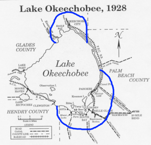
Inland, the hurricane wreaked much more widespread destruction along the more heavily populated coast of Lake Okeechobee. Residents had been warned to evacuate the low ground earlier in the day, but after the hurricane did not arrive on schedule, many thought it had missed and returned to their homes. In the weeks prior to storm, heavy rainfall caused the lake to rise 3 ft (0.91 m) between August 10 and September 10 and filled nearby canals and ditches. Precipitation from the hurricane itself caused Lake Okeechobee to rise further.[24] When the worst of the storm crossed the lake, the south-blowing wind caused a storm surge to overflow the small dike that had been built at the south end of the lake. The resulting flood covered an area of hundreds of square miles with water that in some places was over 20 ft (6 m) deep. Houses were floated off of their foundations and dashed to pieces against any obstacle they encountered.[26] Most survivors and bodies were washed out into the Everglades where many of the bodies were never found.[27] Agricultural losses in the area surrounding Lake Okeechobee were also significant, with virtually all crops destroyed and over 150 tractors suffering damage.[16]
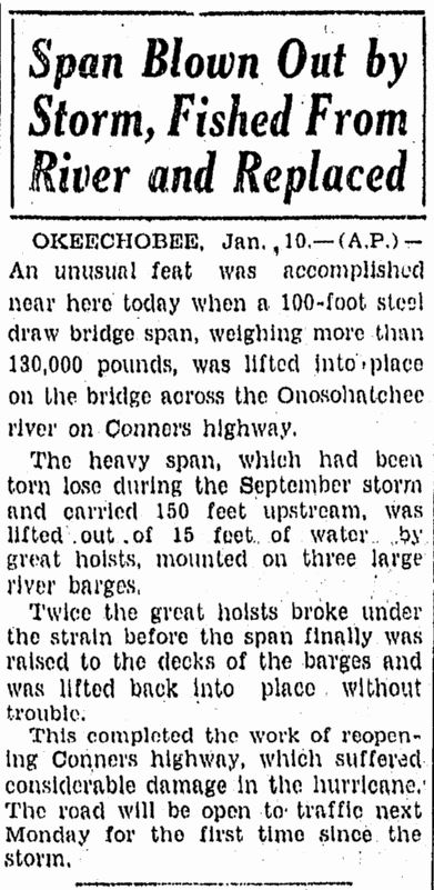
As the rear eyewall passed over the area, the flood reversed itself, breaking the dikes along the northern coast of the lake and causing similar but smaller flooding.[27] Route 98, then known as Conner's Highway, was closed until January, when the bridge across the Onosohatchee River at Taylor Creek was replaced after the original bridge was carried about 150 ft (46 m) upstream during the storm.[28] In Okeechobee County, homes along the lake were destroyed by the storm surge, while dwellings within the city of Okeechobee were severely impacted or demolished by winds of at least 90 mph (140 km/h). However, brick and concrete-structured dwellings received little damage. A number of three-story business buildings collapsed during the storm.[29] Almost all roads were left impassable, while communications were nearly wiped out.[30] Overall, 27 deaths occurred in Okeechobee County. Along the southwestern shore of Lake Okeechobee, the towns of Clewiston and Moore Haven were both flooded, but much of the damage to houses was due to strong winds.[29]
On Kreamer Island, many residents received information about the storm when it was too late to evacuate. In some homes, 20–30 people sought shelter inside and later stood on tables and chairs to remain above the water. Most of the homes were swept away into rows of pine trees and others more than half a mile (0.8 km) away. Despite this, only one person drowned on the island. Residents of Torry Island also did not have ample time to prepare for the storm. They attempted to evacuate, but the causeway was already inundated, forcing twenty-three people to seek refuge in a packinghouse. Floodwaters entered the building, forcing the occupants into the rafters. However, the building was eventually pushed into a nearby canal. Ten people drowned, but thirteen others survived by clinging to a barge or tree tops, while one woman tied herself to a telegraph pole. Others that survived were swept far away from where the building once stood or the barge. A teenage boy was carried from the packinghouse to the Everglades Experiment Station in Belle Glade – a distance of about 8 mi (13 km).[24] On Ritta Island, a number who successfully climbed to the roof of their houses were struck by trees or received fatal bites from water moccasin.[31]
In South Bay, nearly all houses were destroyed and several buildings were unroofed. At least 160 fatalities occurred in the city.[19] Throughout the 1920s, Okeelanta suffered several floods and muck fires. Finally, the town was flooded severely during the storm and was subsequently abandoned.[32] Bean City was also destroyed during the hurricane, but it was eventually rebuilt by Arthur Wells.[33] Sebring Farms was reduced to piles of rubber, with only four tall royal palm trees left standing.[16] Only the hotel at Miami Locks survived the storm.[16] Ninety-nine people died in that town.[16] In Chosen, only two people managed to escape a house that sheltered nineteen people. Twenty other residents took refuge in a building which lost its roof during the storm, forcing the occupants to move into the restroom. A house that was full of people floated about half a mile (0.8 km) from its original location. The refugees were unaware that the house was moving until it collided with a railroad embankment.[24]
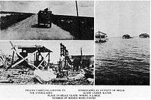
.jpg)
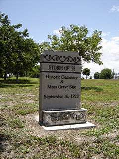
Floodwaters persisted for several weeks, greatly impeding attempts to clean up the devastation. Burial services were quickly overwhelmed, and many of the bodies were placed into mass graves. Around 75% of the fatalities were migrant farm workers, making identification of both dead and missing bodies very difficult; as a result of this, the count of the dead is not very accurate. The Red Cross estimated the number of fatalities as 1,836, which was taken as the official count by the National Weather Service for many years (and exactly equal to the official count for Hurricane Katrina). Older sources usually list 3,411 as the hurricane's total count of fatalities, including the Caribbean. However, in 2003 the U.S. death count was revised to "at least" 2,500, making the Okeechobee hurricane the second-deadliest natural disaster in United States history behind the 1900 Galveston hurricane. A mass grave at the Port Mayaca Cemetery east of Port Mayaca contains the bodies of 1,600 victims of the hurricane.[27]
Central and North Florida
In Fort Myers, property damage was slight, limited mostly to scores of small boats and fishing shacks along the waterfront.[34] Nearly all cigar factories in Tampa were closed after wind and rain drove too much moisture into the buildings.[35] Offshore, the fishing smack Wallace A. McDonnell was beached near Piney Point, though all of the crew survived. Additionally, the Cuban schooner Isabel Alvado sank offshore Boca Grande. The crew, who were immigrants, were rescued by the Coast Guard and later deported.[36] In Martin County, a bridge connecting Stuart and Palm City was severely damaged and closed to traffic as a result. A temporary ferry service across the St. Lucie River was established and operated until repairs to the bridge were complete in the summer of 1929.[37] In Fort Pierce, most of the impact was confined to the waterfront areas. A warehouse, fish houses, docks, and a bridge across the Indian River were destroyed, while several other buildings were unroofed. Damage in the city totaled about $150,000.[19]
In the interior areas of Central and North Florida, impact was mainly confined to agricultural losses, particularly citrus, though wind damage occurred to structures. Between Sebring and Lake Wales, 200 telephone poles were toppled. In Bartow, business building windows were shattered and signs were knocked down, while several roofs and chimneys also suffered damage. Winds gusting up to 70 mph (110 km/h) lashed Lakeland. Many trees were uprooted and several buildings were impacted, including the hospital and a number of businesses. At Florida Southern College (FSC), the north side of the gymnasium collapsed while other buildings on campus were damaged to a less degree. The trees in the citrus grove surrounding FSC lost much of their fruit. Overall, Lakeland suffered about $50,000 in damage.[38] In Orlando, impact to properties was described as slight.[34] Winds up to 50 mph (80 km/h) impacted the Jacksonville area, resulting in minor damage at Jacksonville Beach.[39]
Elsewhere
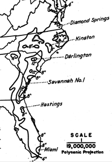
Outside of Florida, damage in the United States was minor from the hurricane.[2] In Georgia, low-lying streets were flooded or washed out in the Savannah area. Additionally, winds downed trees and power lines.[1] Heavy rainfall occurred from eastern Florida through coastal Georgia, the Carolinas, and southeast Virginia. The highest rainfall total was 12.53 inches (318 mm) at Darlington, South Carolina.[40] The storm caused flooding in North Carolina and brought near-hurricane-force winds and a 7 foot (2.1 m) storm surge to the Norfolk area.[41] After the hurricane became extratropical, its wind field became very large. Atlantic City, New Jersey recorded winds of 76 mph (122 km/h) despite being far from the center.[1]
Aftermath
| Rank | Hurricane | Season | Fatalities |
|---|---|---|---|
| 1 | "Galveston" | 1900 | 8,000–12,000† |
| 2 | "Okeechobee" | 1928 | 2,500+† |
| 3 | Katrina | 2005 | 1,836 |
| 4 | "Cheniere Caminada" | 1893 | 1,100–1,400* |
| 5 | "Sea Islands" | 1893 | 1,000–2,000† |
| 6 | "Florida Keys" | 1919 | 778 |
| 7 | "Georgia" | 1881 | 700† |
| 8 | Audrey | 1957 | 416 |
| 9 | "Labor Day" | 1935 | 408 |
| 10 | "Last Island" | 1856 | 400† |
| †estimated total Reference: Deadliest US hurricanes[42] | |||
In the immediate aftermath of the storm, relief arrived from nearby areas such as Miami. Early on September 18, a train leaving Miami carried 20 doctors and 20 nurses to West Palm Beach.[43] The Miami Red Cross Citizens Relief Committee, which was established to provide aid for victims of the storm, transported "hundreds of loaves of bread, gallons of milk, pounds of coffee and sugar, blankets, cots, and medical supplies." The first relief train was ridden by U.S. Senator Joseph T. Robinson, the Democratic vice presidential nominee during the election that year. At least 100 people were brought to Miami for medical treatment. In Lake Worth, 25 people were treated for various injuries at the Gulf Stream Hotel and the local fire station. Dr. W. A. Claxton, chief of the Miami Department of Public Welfare, requested antitoxin, typhoid serum, and at least 200 tetanus serums. There was also a request for 1,000 more cots in West Palm Beach and Kelsey City.[44]
Racial issues
In Florida, although the hurricane destroyed everything in its path with impartiality, the death toll was by far highest in the economically poor areas in the low-lying ground right around Lake Okeechobee, such as Belle Glade, Chosen, Pahokee, South Bay, and Bean City.[45] Around 75% of the fatalities were among migrant farm workers, most of whom were black. The black workers did most of the cleanup work, and the few caskets available for burials were mostly used for the bodies of whites.[46] Additionally, the white victims received a proper burial at Woodlawn Cemetery in downtown West Palm Beach,[45] which was the only mass gravesite to receive a memorial.[46]
In contrast, the bodies of black victims were burned in funeral pyres or thrown into mass burial sites such as the ones in West Palm Beach and Port Mayaca. Robert Hazard, a resident of West Palm Beach, established the Storm of '28 Memorial Park Coalition Inc. to fight for recognition of the black victims of the storm. In 2000, the West Palm Beach burial site was reacquired by the city of West Palm Beach and plans for construction of a memorial began. The site was listed on the U.S. National Register of Historic Places in 2002 and a state historical marker was added in 2003 during the 75th anniversary of the hurricane.[45] The effects of the hurricane on black migrant workers was dramatized in Zora Neale Hurston's novel Their Eyes Were Watching God.[47]
Improved building codes
In the aftermath of the hurricane in coastal Florida, it became apparent that well-constructed buildings with shutters had suffered practically no damage from winds that caused serious structural problems to lesser buildings. Buildings with well-constructed frames, and those made of steel, concrete, brick, or stone were largely immune to winds, and the use of shutters prevented damage to windows and the interior of the buildings. Coming on the heels of the 1926 Miami hurricane where a similar pattern had been noticed, one lasting result of the 1928 storm was improved building codes.[48]
Flood control
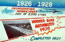
To prevent a recurrence of disasters like this one and the Great Miami Hurricane of 1926, the Florida State Legislature created the Okeechobee Flood Control District, which was authorized to cooperate with the U.S. Army Corps of Engineers in flood control undertakings.[49] After a personal inspection of the area by President Herbert Hoover, the Corps drafted a new plan which provided for the construction of floodway channels, control gates, and major levees along Lake Okeechobee's shores. A long term system was designed for the purpose of flood control, water conservation, prevention of saltwater intrusion, and preservation of fish and wildlife populations.[49] One of the solutions was the construction of the Herbert Hoover Dike. Today, concerns related to the dike's stability have grown in response to studies indicating long term problems with "piping" and erosion. Leaks have been reported after several heavy rain events. Proposed solutions to the dike's problems have included the construction of a seepage berm on the landward side of the dike, with the first stage costing approximately $67 million (US$).[50]
See also
References
- 1 2 3 4 5 6 7 8 9 10 11 12 13 14 Chris Landsea; et al. (April 2014). Documentation of Atlantic Tropical Cyclones Changes in HURDAT (Report). Hurricane Research Division. Retrieved May 2, 2015.
- 1 2 3 4 5 6 7 8 9 10 11 12 13 14 15 16 17 18 Mitchell, Charles (September 1928). "The West Indian Hurricane of September 10–20, 1928" (PDF). Monthly Weather Review: 347–350. Bibcode:1928MWRv...56..347M. doi:10.1175/1520-0493(1928)56<347:TWIHOS>2.0.CO;2. Retrieved April 29, 2010.
- 1 2 National Hurricane Center; Hurricane Research Division (July 6, 2016). "Atlantic hurricane best track (HURDAT version 2)". United States National Oceanic and Atmospheric Administration. Retrieved December 5, 2016.
- ↑ National Hurricane Center; Hurricane Research Division; Atlantic Oceanographic and Meteorological Laboratory (February 2015). "Continental United States Hurricanes (Detailed Description)". aoml.noaa.gov. Miami: United States National Oceanic and Atmospheric Administration's Office of Oceanic & Atmospheric Research. Retrieved December 5, 2016.
- 1 2 3 Orlando Pérez (1970). "Notes on the Tropical Cyclones of Puerto Rico" (PDF). San Juan, Puerto Rico National Weather Service. Retrieved May 2, 2015.
- ↑ Eliot Kleinberg (2003). Black Cloud: The Great Florida Storm of 1928. Carroll & Graf Publishers. p. 87. ISBN 978-0-7867-1146-8.
- 1 2 National Hurricane Center (1995–1997). "The Deadliest Atlantic Tropical Cyclones, 1492–1996". National Oceanic and Atmospheric Administration. Archived from the original on January 28, 2008. Retrieved January 14, 2008.
- 1 2 William G. Innanen. "A Condensed History of Montserrat". Archived from the original on February 12, 2006. Retrieved February 27, 2006.
- 1 2 Vincent K. Hubbard (2002). Swords, Ships & Sugar: History of Nevis. Corvallis, Oregon
- ↑ Chris Landsea, NHC. "FAQ E12: For the USA, what are the 30 highest death toll hurricanes on record?". National Oceanic and Atmospheric Administration. Archived from the original on December 25, 2007. Retrieved January 14, 2008.
- ↑ Don R. Hoy (1961). Agricultural Land Use of Guadeloupe, Issue 12. Washington, D.C.: National Academies Press. p. 64. Retrieved March 15, 2014.
- 1 2 3 4 5 6 Oliver L. Fassig (December 8, 1928). "San Felipe–The Hurricane of September 13, 1928, at San Juan, P.R" (PDF). Monthly Weather Review. American Meteorological Society. 56 (9): 350–352. Bibcode:1928MWRv...56..350F. doi:10.1175/1520-0493(1928)56<350:SFHOSA>2.0.CO;2. Retrieved April 29, 2010.
- 1 2 3 4 5 6 Frank Mújica-Baker. Huracanes y Tormentas que han afectado a Puerto Rico (PDF). Estado Libre Asociado de Puerto Rico, Agencia Estatal para el manejo de Emergencias y Administración de Desastres. pp. 4, 9, 10. Retrieved August 30, 2010.
- ↑ U.S. Southern Command. "Hurricane Preparedness: History". U.S. Army. Archived from the original on December 17, 2007. Retrieved January 14, 2008.
- ↑ Stuart B. Schwartz (Winter 2007). "The 1928 Hurricane and the Shaping of the Circum-Caribbean Region". ReVista: Harvard Review of Latin America. The David Rockefeller Center for Latin American Studies, Harvard University.
- 1 2 3 4 5 6 7 8 9 Wayne Neely (2014). The Great Okeechobee Hurricane of 1928. Bloomington, Indiana: iUniverse. ISBN 978-1-4917-5446-7. Retrieved May 7, 2015.
- ↑ Hurricane Research Division (2008). "All U.S. Hurricanes (1851–2007)". National Oceanic and Atmospheric Administration. Retrieved April 6, 2008.
- ↑ "The Storm: 1928 Remembered" (PDF). Historical Society of Palm Beach County. 2008. p. 9. Retrieved July 24, 2015.
- 1 2 3 4 5 6 "Palm Beach Hurricane—92 Views". Chicago, Illinois: American Autochrome Company. 1928. Retrieved June 27, 2015.
- ↑ "Hurricane Hits City Sunday". Fort Lauderdale Daily News. September 17, 1928. Retrieved May 9, 2015.
- 1 2 "36 Lives Lost is Storm Toll Over Florida" (PDF). Miami Herald. September 18, 1928. Retrieved May 8, 2015.
- ↑ "Few Buildings Escape Damage From Hurricane". The Palm Beach Post. September 18, 1928.
- ↑ National Weather Service (29 June 2009). "Memorial Web Page for the 1928 Okeechobee Hurricane". srh.noaa.gov. Miami, Florida: National Weather Service. Retrieved 21 February 2015.
- 1 2 3 4 Jay Barnes (2007). Florida's Hurricane History. University of North Carolina Press. p. 129. ISBN 978-0-8078-3068-0. Retrieved May 12, 2015.
- ↑ "The Storm: 1928 Remembered (Teacher's Guide)" (PDF). Historical Society of Palm Beach County. 2008: 21. Retrieved March 10, 2015.
- ↑ Jeff Klinkenberg (July 12, 1992). "A storm of memories". St. Petersburg Times. Archived from the original on July 17, 2012. Retrieved May 6, 2015.
- 1 2 3 Nicole Sterghos Brochu (2003). "Florida's Forgotten Storm: the Hurricane of 1928". South Florida Sun-Sentinel. Retrieved April 6, 2008.
- ↑ "Span Blown Out By Storm, Fished From River and Replaced". The Tampa Tribune. Okeechobee, Florida. Associated Press. January 10, 1929. Retrieved May 10, 2015.
- 1 2 "Okeechobee Deaths Laid To Big Wave" (PDF). The Tampa Tribune. September 19, 1928. Retrieved May 13, 2015.
- ↑ "Storm Cannot Be Exaggerated Says Red Cross" (PDF). The Tampa Tribune. September 19, 1928. Retrieved May 13, 2015.
- ↑ Lee Allyn Davis (January 1, 2009). Natural Disasters. New York City, New York: Infobase Publishing. p. 296. ISBN 978-1-4381-1878-9. Retrieved September 9, 2015.
- ↑ "Okeelanta". Historical Society of Palm Beach County. 2009. Retrieved June 27, 2015.
- ↑ Mike Abrams (May 12, 1970). "Bean City". The Palm Beach Post. Bean City, Florida.
- 1 2 Jack Dadswell (September 18, 1928). "Storm Effects Told In Survey Made By Radio". St. Petersburg Times. p. 2. Retrieved July 24, 2015.
- ↑ "Storm Passes To North With Force Lessened" (PDF). The Tampa Tribune. Lakeland, Florida. Retrieved June 27, 2015.
- ↑ "Smack Around, Schooner Sinks During Storm" (PDF). The Tampa Tribune. September 18, 1928. Retrieved June 27, 2015.
- ↑ Alice L. and Greg E. Luckhardt (December 10, 2013). "Historical Vignettes: Chillingworth's Palm City Development". Treasure Coast Newspapers. Stuart, Florida. Retrieved July 25, 2015.
- ↑ "$50,000 Damage Caused to Lakeland Property" (PDF). The Tampa Tribune. Lakeland, Florida. Retrieved June 27, 2015.
- ↑ "Jacksonville and Brunswick, Ga. are Whipped by Winds". St. Petersburg Times. Associated Press. September 18, 1928. p. 1. Retrieved July 24, 2015.
- ↑ United States Corp of Engineers (1945). Storm Total Rainfall In The United States. War Department. p. SA 2–15.
- ↑ David Roth and Hugh Cobb. "Virginia Hurricane History". National Oceanic and Atmospheric Administration. Archived from the original on January 8, 2008. Retrieved January 14, 2008.
- ↑ Blake, Eric S; Landsea, Christopher W; Gibney, Ethan J; National Climatic Data Center; National Hurricane Center (August 10, 2011). The deadliest, costliest and most intense United States tropical cyclones from 1851 to 2010 (and other frequently requested hurricane facts) (PDF) (NOAA Technical Memorandum NWS NHC-6). National Oceanic and Atmospheric Administration. p. 47. Retrieved August 10, 2011.
- ↑ "33 Known Dead in Storm Area; Troops to Aid" (PDF). The Tampa Tribune. September 18, 1928. Retrieved May 12, 2015.
- ↑ "Miami Prompt to Give Aid in Stricken Area" (PDF). Miami Herald. September 18, 1928. Retrieved May 12, 2015.
- 1 2 3 "The Hurricane of 1928". Historical Society of Palm Beach County. 2009. Retrieved May 5, 2015.
- 1 2 Deborah Sharp (September 4, 2003). "Storm's path remains scarred after 75 years". USA Today. Retrieved March 10, 2015.
- ↑ "Florida Properties – African American History Month". National Park Service. Retrieved May 5, 2015.
- ↑ Betty Nelander (2008). "The Hurricane of 1928: Category 4 hurricane scarred Palm Beach". Archived from the original on September 20, 2008. Retrieved June 27, 2008.
- 1 2 "Lake Okeechobee and The Okeechobee Waterway". U.S. Army Corps of Engineers South Florida Operations Office. Archived from the original on June 9, 2007. Retrieved August 3, 2008.
- ↑ "Lake Okeechobee and the Herbert Hoover Dike" (PDF). U.S. Army Corps of Engineers Jacksonville District. Archived from the original (PDF) on October 3, 2008. Retrieved August 3, 2008.
External links
| Wikimedia Commons has media related to Okeechobee Hurricane of 1928. |
| 1920s | |
|---|---|
| 1930s | |
| 1950s | |
| 1960s | |
| 1970s | |
| 1980s | |
| 1990s | |
| 2000s | |
| 2010s | |
| |