1909 Monterrey hurricane
| Category 3 major hurricane (SSHWS/NWS) | |
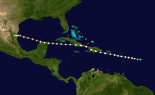
 Map of the northern fringes of the storm on August 27 | |
| Formed | August 20, 1909 |
|---|---|
| Dissipated | August 28, 1909 |
| Highest winds |
1-minute sustained: 120 mph (195 km/h) |
| Lowest pressure | 955 mbar (hPa); 28.2 inHg |
| Fatalities | 4,000 total |
| Damage | $50 million (1909 USD) |
| Areas affected | Leeward Islands, Dominican Republic, Haiti, Cuba, Mexico, and Texas |
| Part of the 1909 Atlantic hurricane season | |
The 1909 Monterrey hurricane was one of the deadliest Atlantic tropical cyclones on record, killing an estimated 4,000 people throughout Mexico. Originating from a tropical storm east of the Leeward Islands on August 20, the storm tracked west-northwest, entering the Caribbean Sea as a minimal hurricane the next day. After striking Hispaniola on August 23, the hurricane made another landfall in eastern Cuba before reentering the Caribbean. Once back over open water, the storm intensified into a Category 3 hurricane and moved across the northern tip of the Yucatán Peninsula. By August 26, the storm had emerged into the Gulf of Mexico as a weakened, but regrouping system. It attained its peak winds of 120 mph (185 km/h) that evening. Maintaining this intensity, the system made landfall in the Mexican state of Tamaulipas late on August 27 and rapidly dissipated the following afternoon.
Throughout its existence, the hurricane remained relatively close to land, so consequently its effects were felt in many areas. Much of the northern Caribbean received moderate to heavy rainfall along with gusty winds during its passage; although only Haiti reported damage from it. Its effects were far more severe in Mexico where an estimated 4,000 people were killed by record-breaking floods triggered by the hurricane. The city of Monterrey received the worst damage: more than half of the structures in the city were flooded, hundreds were destroyed, and 20,000 people were left homeless. Damage from the storm in the country was estimated to have exceeded $50 million (1909 USD; $1.32 billion 2016 USD).
Meteorological history
The origins of the hurricane are uncertain due to a lack of ship reports in the western Atlantic Ocean.[1] According to the Atlantic hurricane database, it was first identifiable as a tropical storm on August 20 to the east of the Leeward Islands. Tracking to the west-northwest, the storm quickly attained winds of 80 mph (130 km/h), equivalent to Category 1 status on the modern-day Saffir–Simpson Hurricane Scale. By the evening of August 21, the storm entered the Caribbean Sea as it brushed the northern coast of Guadeloupe; intensification of the hurricane over the northeastern Caribbean was slow. Early on August 23, it made its first landfall with winds of 90 mph (150 km/h) in San Cristóbal Province, Dominican Republic, just southwest of the country's capital city of Santo Domingo.[2]
The hurricane weakened slightly over the mountainous terrain of Hispaniola, although it is believed to have maintained winds of at least 75 mph (120 km/h) based on damage reports in Haiti.[3] Later on August 23, the storm "jumped" northward before making another landfall in the Cuban province of Guantánamo. Continuing towards the west-northwest, the hurricane regained strength as it moved over the northern Caribbean. During the afternoon of August 24, the system attained winds of 100 mph (155 km/h), corresponding to a Category 2 hurricane. Early the following morning, it further intensified to a Category 3 major hurricane,[2] defined as having winds in excess of 111 mph (178 km/h),[4] before making landfall in the Yucatán Peninsula near the city of Cancún. The hurricane emerged into the Gulf of Mexico within 12 hours and quickly re-intensified to attain its peak winds of 120 mph (185 km/h) on August 26. It soon slowed and turned due west, maintaining its intensity. Late on August 27, the storm made its final landfall in the Mexican state of Tamaulipas. Rapid weakening took place as it drifted onshore, and it dissipated the following afternoon.[2][3]
Impact
| Rank | Hurricane | Season | Fatalities |
|---|---|---|---|
| 1 | "Great Hurricane" | 1780 | 22,000+ |
| 2 | Mitch | 1998 | 19,325+ |
| 3 | "Galveston" | 1900 | 8,000 – 12,000 |
| 4 | Fifi | 1974 | 8,000 – 10,000 |
| 5 | "Dominican Republic" | 1930 | 2,000 – 8,000 |
| 6 | Flora | 1963 | 7,186 – 8,000 |
| 7 | "Pointe-à-Pitre" | 1776 | 6,000+ |
| 8 | "Newfoundland" | 1775 | 4,000 – 4,163 |
| 9 | "Okeechobee" | 1928 | 4,075+ |
| 10 | "Monterrey" | 1909 | 4,000 |
Prior to the hurricane's devastating impacts in Mexico, it brought heavy rains and high winds to several of the northern Caribbean Islands. The first to be affected by the storm were the Leeward Islands; however, no known damage resulted from its passage. Moderate rain and gusty winds were reported in Puerto Rico as well as the Dominican Republic and Jamaica.[5] Despite being slightly weaker once over Haiti, severe damage was reported in many towns, with homes destroyed and many homeless. Much of Cuba was also impacted by the storm, with winds up to 60 mph (95 km/h) being recorded as far north as Havana.[6] During the hurricane's second landfall in Mexico, it brought increased swells and gusty winds, recorded up to 68 mph (109 km/h) to parts of southern Texas.[3] Low-lying areas north of Corpus Christi were inundated by 1 to 3 ft (0.30 to 0.91 m) of water and several piers were damaged. Overall damage in the state was minimal from the storm and no lives were lost.[7]
Although a borderline Category 2–3 hurricane when it made landfall in the Yucatán Peninsula,[2] little is known about the storm's impact in the region. One ship situated about 25 mi (40 km) offshore recorded winds up to 100 mph (155 km/h) during its passage.[6] However, following the hurricane's second landfall, the resulting damage was catastrophic. During the overnight hours between August 27 and 28, cities along the coastline of Tamaulipas likely sustained severe damage from the hurricane's storm surge and high winds.[3] Two villages along the coast were completely destroyed by the storm and communication with much of the region was crippled and not expected to be restored for more than a week. Nine bridges and roughly 50 mi (80 km) of railroad tracks were destroyed in the state.[8]
The worst of the damage took place further inland, within the state of Nuevo León.[3] There, torrential rainfall triggered a flood even exceeding 100-year flood values.[8] According to meteorologists in Mexico, the storm dropped 17.5 in (440 mm) of rain over a 40‑hour span.[9][10] Further rains fell for the following 32 hours, worsening the situation. According to Mexican officials, overnight on August 27, the reservoir dam near Nuevo León's capital city, Monterrey, burst, flooding more than half of the buildings in the city, as well as all of the nearby town of San Luisto.[11] Steel works and smelters situated along the Santa Catarina River were destroyed after the river rose well over its banks.[8][9] Hundreds of homes were destroyed throughout the city,[8] leaving an estimated 20,000 people homeless.[6][12] According to the American Society of Civil Engineers, an enormous 235,000 ft3 (6,650 m3) of water was being moved per second during the height of the flood.[13]
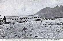
At the height of the floods, residents were forced to seek refuge on the roofs of two-story buildings; however, the Santa Catarina River was flowing at a very fast pace of 20 mph (32 km/h). The force of the current led to most homes being taken off their foundations and sent downstream, resulting in the deaths of anyone inside.[14] In one incident, 90 people died after seeking refuge in a school after their homes collapsed. However, not long after entering the building, flood waters inundated the structure and caused it to collapse.[9] By the morning, survivors reported that the state of the city was "indescribable".[14] Damage from the hurricane was estimated to have been at least $50 million (1909 USD; $1.32 billion 2016 USD).[12] Of this, roughly $20 million was attributed to railroad losses.[15] Throughout Mexico, reports indicated that about 4,000 people were killed as a result of the storm,[16] making it one of the deadliest Atlantic hurricanes on record.[17] Some estimates place the death toll as high as 5,000 and others as low as 3,000.[13] Of these fatalities, 800 are believed to have been in the south side of Monterrey where four blocks of the city were completely destroyed.[14]
Aftermath
Immediately following the catastrophic flooding in Monterrey, an appeal was made to the United States and other nations for aid.[8] Many residents and visitors in the city did all they could to help rescue those trapped in the flood waters and take care of the homeless. According to the New York Times, one person rescued 30 people stranded in flood waters. Numerous rescue operations were undertaken during the flood, saving many lives. However, survivors faced another issue after losing their homes: lack of food. Food was unavailable to most residents in the wake of the storm until August 31 when the first relief supplies arrived. Even then, most only received a small amount of bread and beans. Once the flood along the Santa Catarina River receded, searches were conducted to attempt to locate the bodies of victims. However, reports indicated that the river bed was similar to quicksand and most bodies on it were likely underground.[12]
Days after the storm, fears of food shortages began to arise as railways, in which food would normally be able to be delivered, were washed out.[9] To deal with the large amount of bodies in the wake of the disaster, Mexican officials decided to cremate and mass bury victims.[18] By mid-September, between 1,600 and 1,800 people were hired to repair and rebuild the devastated railways in Nuevo León.[15] In 2009, the third edition of the book El Río Fiera Bramaba: 1909 by Oswaldo Sánchez, re-accounting reports form people who experienced the flood, was planned. According to the director of publications at the Universidad Autónoma de Nuevo León, the book was considered one of historical quality. In memory of those who perished during the flood, the book was released to the public on August 27, 2009, the 100 year anniversary of the disaster.[19][20]
See also
- 1909 Atlantic hurricane season
- List of notable tropical cyclones
- Lists of tropical cyclones
- List of deadliest Atlantic hurricanes
- Hurricane Alex (2010) - Caused similarly disastrous flooding in Monterrey
- Hurricane Charlie (1951)
- Hurricane Gilbert
References
- General
- Partagás, José Fernández; Diaz, H. (1999). A Reconstruction of Historical Tropical Cyclone Frequency in the Atlantic from Documentary and other Historical Sources Part VI: 1909-1910. Climate Diagnostics Center.
- Sánchez, Oswaldo (1989). El Río Fiera Bramaba: 1909. Universidad Autónoma de Nuevo León.
- American Society of Civil Engineers (1910). Proceedings of the American Society of Civil Engineers, Volume 36, Part 2. American Society of Civil Engineers.
- Specific
- ↑ Partagás, pp. 6
- 1 2 3 4 Hurricane Research Specialists Division (2010). "Easy-to-Read HURDAT 1851-2009". National Hurricane Center. Archived from the original on 15 May 2010. Retrieved May 12, 2010.
- 1 2 3 4 5 Partagás, pp. 9
- ↑ Timothy Schott; Chris Landsea; Gene Hafele; Jeffrey Lorens; Arthur Taylor; Harvey Thurm; Bill Ward; Mark Willis; Walt Zaleski (February 17, 2010). "The Saffir-Simpson Hurricane Wind Scale" (PDF). National Hurricane Center. Retrieved May 16, 2010.
- ↑ Partagás, pp. 7
- 1 2 3 Partagás, pp. 8
- ↑ "1909 Monthly Weather Review" (PDF). World Meteorological Organization. 1909. Retrieved May 16, 2010.
- 1 2 3 4 5 Staff Writer (August 29, 1909). "Parts of City Washed Away". New York Times. p. 1.
- 1 2 3 4 Staff Writer (August 30, 1909). "1,200 Persons Lost In Monterrey Flood". New York Times. p. 1.
- ↑ Staff Writer (August 28, 1909). "Rain Fell For 40 Hours". New York Times. p. 1.
- ↑ Staff Writer (August 30, 1909). "List Of Lost Is More Than Thousand". The Miami News. p. 1. Retrieved May 17, 2010.
- 1 2 3 Staff Writer (August 31, 1909). "Flood Death List Now Reaches 2,000". New York Times. p. 4.
- 1 2 American Society of Civil Engineers, pp. 1669
- 1 2 3 Staff Writer (August 29, 1909). "800 Mexicans Die In Flood". New York Times. p. 1.
- 1 2 Staff Writer (September 16, 1909). "Twenty Millions Mexican R.R. Loss". The Christian Science Monitor. p. 7.
- ↑ Staff Writer (August 27, 2009). "Inundación de Monterrey en 1909" (in Spanish). El Periódico de Nuevo León. Retrieved May 16, 2010.
- ↑ Edward N. Rappaport; Jose Fernandez-Partagas; Jack L. Beven (April 22, 1997). "The Deadliest Atlantic Tropical Cyclones, 1492-1996". National Hurricane Center. Retrieved May 16, 2010.
- ↑ Special News Service (September 3, 1909). "Burning The Bodies Of Flood Victims". Dawson Daily News. p. 53. Retrieved May 17, 2010.
- ↑ Staff Writer (August 20, 2009). "Reeditan texto que narra tragedia de 1909" (in Spanish). Milenio. Retrieved May 16, 2010.
- ↑ ""El Rio Fiera…" 100 Years after the Floods". Universidad Autónoma de Nuevo León. January 9, 2009. Retrieved 23 May 2010.
External links
Tropical cyclones of the 1909 Atlantic hurricane season | ||
|---|---|---|
 | ||
| ||