1856 Last Island hurricane
| Category 4 major hurricane (SSHWS/NWS) | |
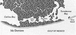 Map of Last Island, Louisiana in 1853 | |
| Formed | Before August 9, 1856 |
|---|---|
| Dissipated | August 12, 1856 |
| Highest winds |
1-minute sustained: 150 mph (240 km/h) |
| Lowest pressure | 934 mbar (hPa); 27.58 inHg |
| Fatalities | 200+ |
| Areas affected | Louisiana and southwestern Mississippi |
| Part of the 1856 Atlantic hurricane season | |
The 1856 Last Island hurricane (also known as the Great Storm of 1856) was one of the deadliest tropical cyclones recorded for Louisiana. The first known tropical cyclone of the season, it was observed first as a minimal hurricane in the Gulf of Mexico near Dry Tortugas on August 9.
Offshore, at least 183 people drowned after steamers and schooners sank in rough seas produced by the hurricane. A storm surge between 11 and 12 feet (3.4 and 3.7 m) completely submerged the island, destroying virtually every structure, including the hotels and casinos, while all crops were ruined. Additionally, Last Island itself was split in two.
Inland, heavy rainfall caused the Mermentau River to flood, destroying crops and every house in Abbeville. The storm produced as much as 13.14 inches (334 mm) of precipitation in New Orleans. In Plaquemines Parish, rice fields were under several feet of water, while many orange trees lost their fruit. The storm resulted in at least 200 fatalities.
Meteorological history
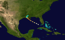
The cyclone was first detected in the eastern Gulf of Mexico 125 miles (200 km) west-northwest of Key West, Florida, on August 8, 1856. Because it was already a hurricane when it was first observed, it probably had developed further east than here. It advanced steadily northwest, strengthening to the equivalent of a Category 3 hurricane. The hurricane gradually slowed prior to landfall on August 10, and it attained its estimated peak intensity of 150 mph (240 km/h). It was a tropical cyclone of small diameter, and its maximum sustained winds may have reached Category 5 status, but were unrecorded. During the early evening of August 10 the northeastern edge of the eye crossed over Last Island (Official name: Isle Dernière) before making landfall a few hours later south of New Iberia, Louisiana. The cyclone is believed to have struck southern Louisiana at peak intensity with an approximate central pressure of 934 mbar (27.58 inHg).[1] A ship reported a peripheral pressure of 955 mbar (28.20 inHg),[2] so a lower pressure was based on the small size of the hurricane. It quickly weakened over land, and it diminished to a tropical storm on August 11. It dissipated over southwestern Mississippi on August 12 with fully tropical characteristics.[1]
Impact and aftermath
Last Island
Many vacationers hoping to escape were awaiting the scheduled arrival of the ship Star, which provided regular service to the mainland. However, the Star was blown off course, barely escaping sailing into the open gulf, directly into the hurricane, where it would have almost certainly been lost. Passenger Tom Ellis, an experienced captain in local waters, and a few other passengers noticed the ship was off course. Ellis alerted Captain Abe Smith, who corrected the course and barely making headway against the winds, managed to pull into the channel behind the hotel. The Star was swept, crashing into shore and beached on the sand, where it stayed through the storm.[3]
Visibility during the storm was extremely limited and eyes were blasted by sand until water covered the beaches. Sometime between 4:00 and 5:00 PM the storm surge occurred suddenly, with the water rising several feet in a matter of minutes. The storm surge submerged the entire island and destroyed all of the buildings. The hotel, which held many women and children on the second floor and men on the first, collapsed, crushing many and sweeping others out to sea.[3]
Several survivors managed to make their way to the hull of the Star. By tying himself with a rope to the Star, Captain Abe Smith was able to rescue at least 40 people from the storm surge.[3] The Star would serve as a shelter for the survivors until rescuers arrived three days later.
Many managed to survive by sheltering in or behind overturned cisterns, which were large wooden cylindrical tanks reinforced with iron hoops. Some clung to the raised foundations of the cisterns and a few to trees. A dozen people survived by clinging to a large piece of rotating playground equipment atop a levee.[4] Many people floated on debris, including wall sections, logs and furniture. A sturdy wooden enclosure that held large terrapins, a regional delicacy, provided enough protection to save several individuals. Another group survived by burying their feet in the sand and holding hands. Some survivors were carried to the marshes on the mainland, although some perished from injuries or lack of food and water.[3]
Of the approximately 400 vacationers on the island, 198 were known or presumed dead and 203 were known survivors. Dixon (2009) provides lists of survivors and the dead.[3]
The tragedy greatly affected the planter society, which lost many members. At the time of the hurricane approximately two-thirds of the millionaires in the U.S. lived in Louisiana, many of those being plantation owners, especially sugar growers. Of the social group affected, many were friends, acquaintances, or related by marriage or known through business.
Several of the victims were slaves. Some of the slaves were credited with rescuing people, including several children.
The family home of three of the Last Island casualties was Shadows-on-the-Teche in New Iberia, Louisiana, now a National Historic Landmark. Mrs. Frances Weeks (Magill) Pruett and her children Mary Ida Magill and Augustine Magill died in the natural disaster. The two children were buried in the plantation's cemetery.[5]
The island itself was split into the Last Islands (Isles Dernieres).[6] The island reportedly stayed submerged for several days before parts of it re-emerged as large sandbars. After the storm surge, the remains of the Star were the only sign that an island had ever existed there. Presently, the area is used by pelicans and other birds.[6]
Elsewhere
The following is the number of deaths offshore:[3]
- Steamer Nautilus: 85
- Steamer Manilla: 13
- Schooner Ellen: 15
- Other losses at sea: 20
The city of New Orleans was inundated with 13.14 inches (335 mm) of rain. Every building in the town of Abbeville, Louisiana, was destroyed. There was severe flooding throughout Plaquemines Parish.[6]
In print
The disaster became national news as soon as three survivors salvaged a small boat and sailed to the mainland for help.
In addition to the several first hand accounts, the story of Lost Island has been republished periodically. The list below includes only a few versions:
- In 1871 Harper's New Monthly had a story about the capsizing of the steamer Nautilus and Jim Frisbee, the ship's second steward, the only survivor.
- Lafcadio Hearn's novel Chita: A Memory of Last Island (1889), based on the Last Island hurricane of 1856, was a popular story when published; however, it either created or perpetuated several myths about the tragedy. One of the main sources of Hearn's novel was identified as the account written by Iberville Parish sugar planter Michael Shlatre. After publication of Chita, Michael Shlatre's document became lost after being borrowed and not returned. The document was recovered during 1936, when it was found in the Iberville Parish courthouse in Plaquemine, La..
- Bill Dixon's Last Days of Last Island (2009) was written using information from various archives in an attempt to be historically accurate. The numerous references include a newspaper article, a few books, and accounts of the survivors, many of whom are quoted.[3]
Bibliography
- Last Island, by James M. Sothern, Market$hare Enterprises, 1980.
- Last Days of Last Island, by Bill Dixon, University of Louisiana at Lafayette Press, 2009. ISBN 1-887366-88-1
- Island in a Storm: A Rising Sea, a Vanishing Coast, and a Nineteenth-Century Disaster that Warns of a Warmer World, by Abby Sallenger, Public Affairs, Perseus Book Group, NY, 2009. ISBN 1-58648-515-6, ISBN 978-1-58648-515-3
See also
- Last Island, Louisiana
- 1856 Atlantic hurricane season
- List of Atlantic hurricanes
- List of tropical cyclones
References
- 1 2 National Hurricane Center; Hurricane Research Division (July 6, 2016). "Atlantic hurricane best track (HURDAT version 2)". United States National Oceanic and Atmospheric Administration. Retrieved December 5, 2016.
- ↑ Partagas, Jose Fernandez; Dias, H. F. (1995). "Part One: Year 1856" (PDF). NOAA. Archived (PDF) from the original on 27 February 2008. Retrieved 2008-02-19.
- 1 2 3 4 5 6 7 Dixon, Bill (2009). Last Days of Last Island: The Hurricane of 1856, Louisiana’s First Great Storm. Lafayette, LA: University of Louisiana at Lafayette Press. ISBN 1-887366-88-1.
- ↑ "A minister tempered by the elements". Lafourche.com. Retrieved 2008-02-19.
- ↑ http://www.findagrave.com/cgi-bin/fg.cgi?page=gr&GScid=2352989&GRid=71058250&
- 1 2 3 Roth, David. "Louisiana Hurricane History: Late 19th Century". National Weather Service. Archived from the original on 2008-05-21. Retrieved 2008-02-19.
External links
- NOLA.com article about the storm
- NOAA list of intense hurricanes
- Louisiana hurricane history
- Robert McAllister's eyewitness account
- The Deadliest Atlantic Tropical Cyclones, 1492–1996
- 1856 account of the Hurricane
- Chita: A Memory of Lost Island, Lafcadio Hearn