1854 Tōkai earthquake
  | |
| Date | December 23, 1854 |
|---|---|
| Magnitude | 8.4 ML |
| Epicenter | 34°00′N 137°48′E / 34.0°N 137.8°ECoordinates: 34°00′N 137°48′E / 34.0°N 137.8°E |
| Areas affected | Japan, Tōkai region |
| Tsunami | yes |
| Casualties | >2,000 |
The 1854 Tōkai earthquake was the first of the Ansei great earthquakes (1854–1855). It occurred at about 09:00 local time on 23 December 1854. It had a magnitude of 8.4 and caused a damaging tsunami. More than 10,000 buildings were destroyed and there were at least 2,000 casualties.[1]
It was the first of the three Ansei great earthquakes; the 1854 Ansei-Nankai earthquake of similar size hit southern Honshu the following day.
Background
The southern coast of Honshu runs parallel to the Nankai Trough, which marks the subduction of the Philippine Sea Plate beneath the Eurasian Plate. Movement on this convergent plate boundary leads to many earthquakes, some of them of megathrust type. The Nankai megathrust has five distinct segments (A-E) that can rupture independently,[2][3] the segments have ruptured either singly or together repeatedly over the last 1300 years.[4] Megathrust earthquakes on this structure tend to occur in pairs, with a relatively short time gap between them. In addition to the two events in 1854, there were similar earthquakes in 1944 and 1946. In each case the northeastern segment ruptured before the southwestern segment.[5]
Damage
Much of central Japan experienced seismic intensities of 5 (on the JMA scale). Damage from this earthquake was particularly severe in the coastal areas of Shizuoka Prefecture from Numazu to Tenryu River, with many houses being damaged or destroyed.[6]
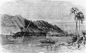
On the east side of the Izu Peninsula, Shimoda was hit by the tsunami one hour after the earthquake. A series of nine waves struck the city, destroying 840 houses and claiming 122 lives. Diana, the flagship of a visiting Russian admiral, Putyatin, was spun round 42 times on its moorings and was so badly damaged that it sank in a later storm.[6]
At Suruga Bay, on the west side of the Izu Peninsula, the village of Iruma was destroyed and a 10 m high sand dome was deposited, on which the village was later reconstructed.[6]
Characteristics
Earthquake
The rupture area, magnitude and epicenter have been estimated from seismic intensity measurements, information about tsunami arrival times and evidence of co-seismic uplift/subsidence.[1][6]
Tsunami
In most of the affected areas, run-up heights were in the range of 4–6 m. At Iruma, run-up heights of 13.2 and 16.5 m have been measured, much higher than most of the surrounding area. This and the deposition of the unusual sand dome, with an estimated volume of 700,000 m3, is interpreted to have been caused by the effects of resonance in the V-shaped Iruma bay.[6]
See also
References
- 1 2 Usami, T. (1979). "Study of Historical Earthquakes in Japan" (PDF). Bulletin of the Earthquake Research Institute. 54: 399–439. Retrieved 2009-11-13.
- ↑ Ando, M. (1975). "Source mechanisms and tectonic significance of historical earthquakes along the nankai trough, Japan". Tectonophysics. 27 (2): 119–140. Bibcode:1975Tectp..27..119A. doi:10.1016/0040-1951(75)90102-X. Retrieved 2009-11-13.
- ↑ Ishibashi, K. (2004). "Status of historical seismology in Japan" (PDF). Annals of Geophysics. 47 (2/3): 339–368. Retrieved 2009-11-22.
- ↑ Sieh, K.E. (1981). A Review of Geological Evidence for Recurrence Times of Large Earthquakes (PDF). Retrieved 2009-11-13.
- ↑ Kaneda, Y.; Kawaguchi, K.; Araki, E.; Matsumoto, H.; Nakamura, T.; Kamiya, S.; Hori, T. & Baba, T. (2007). "Precise real-time observatory and simulating phenomena of earthquakes and tsunamis around the Nankai Trough - Towards the understanding of mega thrust earthquakes". Underwater Technology and Workshop on Scientific Use of Submarine Cables and Related Technologies, 2007. Symposium on: 299–300. Retrieved 2009-11-13.
- 1 2 3 4 5 Sugawara, D.; Minoura K.; Imamura F.; Takahashi T. & Shuto N. (2005). "A huge sand dome, ca. 700,000 m3 in volume, formed by the 1854 Earthquake Tsunami in Suruga Bay, Central Japan" (PDF). ISET Journal of Earthquake Technology. 42 (4): 147–158. Retrieved 2009-11-14.