Kerguelen Islands
| Kerguelen Islands Îles Kerguelen |
||||
|---|---|---|---|---|
|
||||
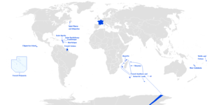
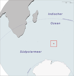 Location of the Kerguelen Islands in the Southern Ocean
|
||||
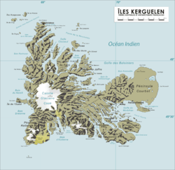 Map of the Kerguelen Islands
|
||||
| Largest city | Port-aux-Français | |||
| Official languages | French | |||
| Government | District of the French Southern and Antarctic Lands | |||
| • | President | François Hollande | ||
| • | Administrator | Pascal Bolot[1] | ||
| • | Head of District | Disker[1] | ||
| French overseas territory | ||||
| • | Discovery | February 1772 | ||
| Area | ||||
| • | Total | 7,215 km2 2,786 sq mi |
||
| Population | ||||
| • | estimate | around 45 (winter) around 110 (summer) |
||
| Currency | Euro (EUR) | |||
| Time zone | (UTC4) | |||
| Calling code | +262 | |||
| Internet TLD | .tf | |||
The Kerguelen Islands (/ˈkɜːrɡəlɛn/ or /ˈkɜːrɡələn/;[2] in French Îles Kerguelen but officially Archipel des Kerguelen, pronounced: [kɛʁɡeˈlɛn]), also known as the Desolation Islands (Îles de la Désolation in French), are a group of islands in the southern Indian Ocean constituting one of the two exposed parts of the mostly submerged Kerguelen Plateau. They are among the most isolated places of Earth, located 450 km (280 mi) northwest of the uninhabited Heard Island and McDonald Islands and more than 3,300 km (2,051 mi) from the nearest populated location, along Madagascar (except the Alfred Faure scientific station in Île de la Possession, about 1340 km from there, and non-permanent station located in Île Amsterdam, 1,440 km away). The islands, along with Adélie Land, the Crozet Islands and the Amsterdam and Saint Paul Islands, are part of the French Southern and Antarctic Lands and are administered as a separate district.
The main island, Grande Terre, is 6,675 km2 (2,577 sq mi) in area and is surrounded by a further 300 smaller islands and islets,[3] forming an archipelago of 7,215 km2 (2,786 sq mi). The climate is raw and chilly with frequent high winds throughout the year. The surrounding seas are generally rough and they remain ice-free year-round. There are no indigenous inhabitants, but France maintains a permanent presence of 45 to 100 scientists, engineers and researchers.[4] There are no airports on the islands, so all travel and transport from the outside world is conducted by ship.
History

Kerguelen Islands appear as the "Ile de Nachtegal" on Philippe Bauche's map from 1754 before the island was officially discovered in 1772. The Bauche map has the title Carte des Terres Australes comprises entre le Tropique du Capricorne et le Pôle Antarctique où se voyent les nouvelles découvertes faites en 1739 au Sud du Cap de Bonne Esperance (‘Map of the Southern Lands contained between the Tropic of Capricorn and the Antarctic Pole, where the new discoveries made in 1739 to the south of the Cape of Good Hope may be seen’). It is possible this early name was after Tasman's ship "De Zeeuwsche Nachtegaal." On the Bauche map, "Ile de Nachtegal" is located at 43°S, 72°E, about 6 degrees north and 2 degrees east of the accepted location of Grande Terre.
The islands were officially discovered by the French navigator Yves-Joseph de Kerguelen-Trémarec on 12 February 1772. The next day Charles de Boisguehenneuc landed and claimed the island for the French crown.[5] Yves de Kerguelen organised a second expedition in 1773 and arrived at the " baie de l'Oiseau " by December of the same year. On 6 January 1774 he commanded his lieutenant, Henri Pascal de Rochegude, to leave a message notifying any passers-by of the two passages and of the French claim to the islands.[6] Thereafter, a number of expeditions briefly visited the islands, including that of Captain James Cook in December 1776, who verified and confirmed the passage of de Kerguelen by discovering and annotating the message left by the French navigator.[6]

Soon after their discovery, the archipelago was regularly visited by whalers and sealers (mostly British, American and Norwegian) who hunted the resident populations of whales and seals to the point of near extinction, including fur seals in the 18th century and elephant seals in the 19th century. Since the end of the whaling and sealing era, most of the islands' species have been able to increase their population again.[7]
In 1800, Hillsborough spent eight months sealing and whaling around the islands. During this time Captain Robert Rhodes, her master, prepared a chart of the islands.[8]
In 1825, the British sealer John Nunn and three crew members from Favourite, were shipwrecked on Kerguelen until they were rescued in 1827 by Captain Alexander Distant during his hunting campaign.[9] [10]
_p182_THE_EGG-CART.jpg)
The islands were not completely surveyed until the Ross expedition of 1840[11]
For the 1874 transit of Venus, George Biddell Airy at the Royal Observatory of the UK organised and equipped five expeditions to different parts of the world. Three of these were sent to the Kerguelen Islands. The Reverend Stephen Joseph Perry led the British expeditions to the Kerguelen Islands. He set up his main observation station at Observatory Bay and two auxiliary stations, one at Thumb Peak (49°30′47.3″S 70°10′18.1″E / 49.513139°S 70.171694°E) led by Sommerville Goodridge, and the second at Supply Bay (49°30′47.3″S 69°46′13.2″E / 49.513139°S 69.770333°E) led by Cyril Corbet. Observatory Bay was also used by the German Antarctic Expedition led by Erich Dagobert von Drygalski in 1902–03. In January 2007, an archaeological excavation of this site was carried out.
In 1874–1875, British, German and U.S. expeditions visited Kerguelen to observe the transit of Venus.[12]
In 1877 the French started a coal mining operation; however, this was abandoned soon after.[13]

The Kerguelen Islands, along with the islands of Amsterdam and St Paul, and the Crozet archipelago were officially annexed by France in 1893, and were included as possessions in the French constitution in 1924 (in addition to that portion of Antarctica claimed by France and known as Adélie Land; as with all Antarctic territorial claims, France's possession on the continent is held in abeyance until a new international treaty is ratified that defines each claimant's rights and obligations).
The German auxiliary cruiser Atlantis called at Kerguelen during December 1940. During their stay the crew performed maintenance and replenished their water supplies. This ship's first fatality of the war occurred when a sailor, Bernhard Herrmann, fell while painting the funnel. He is buried in what is sometimes referred to as "the most southerly German war grave" of World War II.
Kerguelen has been continually occupied since 1950 by scientific research teams, with a population of 50 to 100 frequently present.[4] There is also a French satellite tracking station.
Until 1955, the Kerguelen Islands were administrative-wise part of the French Colony of Madagascar and Dependencies. That same year they collectively became known as Les Terres australes et antarctiques françaises (French Southern and Antarctic Lands) and were administratively part of the French Départment d'outre-mer de la Réunion. In 2004 they were permanently transformed into their own entity (keeping the same name) but having inherited another group of five very remote tropical islands, les îles Éparses, which are also owned by France and are dispersed widely throughout the southern Indian Ocean.
Grande Terre


The main island of the archipelago is called La Grande Terre. It measures 150 km (93 mi) east to west and 120 km (75 mi) north to south.
Port-aux-Français, a scientific base, is along the eastern shore of the Gulf of Morbihan on La Grande Terre at 49°21′S 70°13′E / 49.350°S 70.217°E. Facilities there include scientific-research buildings, a satellite tracking station, dormitories, a hospital, a library, a gymnasium, a pub, and the chapel of Notre-Dame des Vents.
The highest point is Mont Ross in the Gallieni Massif, which rises along the southern coast of the island and has an elevation of 1,850 metres (6,070 ft). The Cook Ice Cap (French: Calotte Glaciaire Cook),[14] France's largest glacier with an area of about 403 km2 (156 sq mi), lies on the west-central part of the island. Overall, the glaciers of the Kerguelen Islands cover just over 500 km2 (190 sq mi). Grande Terre has also numerous bays, inlets, fjords, and coves, as well as several peninsulas and promontories. The most important ones are listed below:
- Courbet Peninsula
- Péninsule Rallier du Baty
- Péninsule Gallieni
- Péninsule Loranchet
- Péninsule Jeanne d'Arc
- Presqu'île Ronarc'h
- Presqu'île de la Société de Géographie
- Presqu'île Joffre
- Presqu'île du Prince de Galles
- Presqu'île du Gauss
- Presqu'île Bouquet de la Grye
- Presqu'île d'Entrecasteaux
- Presqu'île du Bougainville
- Presqu'île Hoche
Notable localities
There are also a number of notable localities, all on La Grande Terre (see also the main map):
- Anse Betsy [Betsy Cove] (a former geomagnetic station at 49°10′S 70°13′E / 49.167°S 70.217°E), on Baie Accessible [Accessible Bay], on the north coast of the Courbet Peninsula. On this site an astronomical and geomagnetic observatory was erected on 26 October 1874 by a German research expedition led by Georg Gustav Freiherr von Schleinitz. The primary goal of this station was the 1874 observation of the transit of Venus.
- Armor (Base Armor), established in 1983, is located 40 km (25 mi) west of Port-aux-Français at the bottom of Morbihan Gulf, for the acclimatization of salmon to the Kerguelen islands.[15]
- Baie de l'Observatoire [Observatory Bay] (a former geomagnetic observation station at 49°21′S 70°12′E / 49.350°S 70.200°E), just west of Port-Aux-Français, on the eastern fringe of the Central Plateau, along the northern shore of the Golfe du Morbihan.
- Cabane Port-Raymond (scientific camp at 49°20′S 69°49′E / 49.333°S 69.817°E), at the head of a fjord cutting into the Courbet Peninsula from the south.
- Cap Ratmanoff (geomagnetic station at 49°14′S 70°34′E / 49.233°S 70.567°E), the eastmost point of the Kerguelens.
- La Montjoie (scientific camp at 48°59′S 68°50′E / 48.983°S 68.833°E), on the south shore of Baie Rocheuse, along the northwestern coast of the archipelago.
- Molloy (Pointe Molloy), a former observatory ten kilometers west of the present-day Port-Aux-Français, along the south coast of the Courbet Peninsula, or northern shore of the Golfe du Morbihan (Kerguelen), at 49°21′38″S 70°3′50″E / 49.36056°S 70.06389°E. An American expedition led by G. P. Ryan erected a station at this site on 7 September 1874. That station was also established to observe the 1874 transit of Venus.
- Port Bizet (seismographic station at 49°31′12″S 69°54′36″E / 49.52000°S 69.91000°E), on the northeastern coast of Île Longue. This also serves as the principal sheep farm for the island's resident flock of Bizet sheep.
- Port Christmas (a former geomagnetic station at 48°41′S 69°03′E / 48.683°S 69.050°E), on Baie de l'Oiseau, in the extreme northwest of the Loranchet Peninsula. This place was so named by Captain James Cook, who re-discovered the islands and who anchored there on Christmas Day, 1776. This is also the place where Captain Cook coined the name "Desolation Islands" in reference to what he saw as a sterile landscape.
- Port Couvreux (a former whaling station, experimental sheep farm, and geomagnetic station, at 49°17′S 69°42′E / 49.283°S 69.700°E), on Baie du Hillsborough, on the southeast coast of Presqu'île Bouquet de la Grye. Starting in 1912, sheep were raised here to create an economic base for future settlement. However, the attempt failed and the last inhabitants had to be evacuated, and the station abandoned, in 1931. The huts remain, as well as a graveyard with five anonymous graves. These are those of the settlers who were unable to survive in the harsh environment.
- Port Curieuse (a harbor on the west coast across Île de l'Ouest 49°22′S 68°48′E / 49.367°S 68.800°E). The site was named after the ship La Curieuse, which was used by Raymond Rallier du Baty on his second visit to the islands (1913–14).
- Port Douzième (literally Twelfth Port, a hut and former geomagnetic station at 49°31′S 70°09′E / 49.517°S 70.150°E), on the north coast of Presqu'île Ronarch, southern shore of the Golfe du Morbihan.
- Port Jeanne d'Arc (a former whaling station founded by a Norwegian whaling company in 1908, and a former geomagnetic station at 49°33′S 69°49′E / 49.550°S 69.817°E), in the northwestern corner of Presqu'île Jeanne d'Arc, looking across the Buenos Aires passage to Île Longue (4 km (2.5 mi) northeast). The derelict settlement consists of four residential buildings with wooden walls and tin roofs, and a barn. One of the buildings was restored in 1977, and another in 2007.
From 1968 to 1981, 49°21′S 70°16′E / 49.350°S 70.267°E just east of Port-aux-Français was a launching site for sounding rockets, some for French (Dragon rockets), American (Arcas) or French-Soviet (Eridans) surveys, but at the end mainly for a Soviet program (M-100).[16] It is understood the islands have received the attention of the French military.
Islands
The following is a list of the most important adjacent islands:
- Île Foch in the north of the archipelago, at 49°0′S 69°17′E / 49.000°S 69.283°E, is the largest satellite island with an area of 206.2 km². Its highest point, at 687 m, is called La Pyramide Mexicaine.
- Île Howe which lies less than one kilometre off the northern coast of Ile Foch is, at ~54 km², the second most important offlier in the Kerguelens (48°52′S 69°27′E / 48.867°S 69.450°E).
- Île Saint-Lanne Gramont, is to the west of Île Foch in the Golfe Choiseul. It has an area of 45.8 km². Its highest point reaches 480 m (48°55′S 69°12′E / 48.917°S 69.200°E).
- Île du Port, also in the north in the Golfe des Baleiniers at 49°11′S 69°36′E / 49.183°S 69.600°E, is the fourth largest satellite island with an area of 43 km², near its centre it reaches an altitude of 340 m.
- Île de l'Ouest (west coast, about 33 km², 49°21′S 68°44′E / 49.350°S 68.733°E)
- Île Longue (southeast, about 35 km² 49°32′S 69°54′E / 49.533°S 69.900°E)
- Îles Nuageuses (northwest, including île de Croÿ, île du Roland, îles Ternay, îles d'Après, 48°37′S 68°44′E / 48.617°S 68.733°E)
- Île de Castries (48°41′S 69°29′E / 48.683°S 69.483°E)
- Îles Leygues (north, including île de Castries, île Dauphine, 48°41′S 69°29′E / 48.683°S 69.483°E)
- Île Violette (49°07′S 69°40′E / 49.117°S 69.667°E)
- Île Australia (also known as Île aux Rennes – Reindeer Island) (western part of the Golfe du Morbihan, area 36.7 km², altitude 145 m, 49°27′S 69°51′E / 49.450°S 69.850°E)
- Île Haute (western part of the Golfe du Morbihan, altitude 321 m, 49°23′S 69°55′E / 49.383°S 69.917°E)
- Île Mayès (49°28′20″S 69°55′55″E / 49.47222°S 69.93194°E)
- Îles du Prince-de-Monaco (south, in the Audierne bay, 49°36′S 69°14′E / 49.600°S 69.233°E)
- Îles de Boynes (four small islands 30 km south of Presqu'ile Rallier du Baty on the main island, 50°01′S 68°52′E / 50.017°S 68.867°E)
- Île Altazin (a small island in the Swains Bay, 49°38′S 69°45′E / 49.633°S 69.750°E)
- Île Gaby (a small island in the Swains Bay, 49°39′S 69°46′E / 49.650°S 69.767°E)
Economy

Principal activities on the Kerguelen Islands focus on scientific research – mostly earth sciences and biology.
The former sounding rocket range to the east of Port-aux-Français 49°21′S 70°16′E / 49.350°S 70.267°E is currently the site of a SuperDARN radar.
Since 1992, the French Centre National d'Études Spatiales (CNES) has operated a satellite and rocket tracking station which is located four kilometers east of Port-aux-Français. CNES needed a tracking station in the Southern Hemisphere, and the French government required that it be located on French territory, rather than in a populated, but foreign, place like Australia or New Zealand.
Agricultural activities were limited until 2007 to raising sheep (about 3,500 Bizet sheep – a breed of sheep that is rare in mainland France) on Longue Island for consumption by the occupants of the base, as well as small quantities of vegetables in a greenhouse within the immediate vicinity of the main French base. There are also feral rabbits and sheep that can be hunted, as well as wild birds.
There are also 5 fishing boats and vessels, owned by fishermen on Réunion Island (a department of France about 3,500 km (2,300 miles) to the north) who are licensed to fish within the archipelago's Exclusive Economic Zone.
Geology

The Kerguelen islands form an emerged part of the submerged Kerguelen Plateau, which has a total area nearing 2.2 million square kilometres. The plateau was built by volcanic eruptions associated with the Kerguelen hotspot, and now lies on the Antarctic plate.[17]
The major part of the volcanic formations visible on the islands is characteristic of an effusive volcanism, which caused a trap rock formation to start emerging above the level of the ocean 35 million years ago. The accumulation is of a considerable amount; basalt flows, each with a thickness of three to ten metres, stacked on top of each other, sometimes up to a depth of 1,200 metres. This form of volcanism creates a monumental relief shaped as stairs of pyramids.
Other forms of volcanism are present locally, such as the strombolian volcano Mont Ross, and the volcano-plutonic complex on the Rallier du Baty peninsula. Various veins and extrusions of lava such as trachytes, trachyphonolites and phonolites are common all over the islands.
No eruptive activity has been recorded in historic times, but some fumaroles are still active in the South-West of the Grande-Terre island.

A few lignite strata, trapped in basalt flows, reveal fossilised araucarian fragments, dated at about 14 million years of age.
Glaciation caused the depression and tipping phenomena which created the gulfs at the north and east of the archipelago. Erosion caused by the glacial and fluvial activity carved out the valleys and fjords; erosion also created conglomerate detrital complexes, and the plain of the Courbet Peninsula.
The islands are part of a submerged microcontinent called the Kerguelen sub-continent.[18] The microcontinent emerged substantially above sea level for three periods between 100 million years ago and 20 million years ago. The so-called Kerguelen sub-continent may have had tropical flora and fauna about 50 million years ago. The Kerguelen sub-continent finally sank 20 million years ago and is now one to two kilometers below sea level. Kerguelen's sedimentary rocks are similar to ones found in Australia and India, indicating they were all once connected. Scientists hope that studying the Kerguelen sub-continent will help them discover how Australia, India, and Antarctica broke apart.[19]
Climate
Kerguelen's climate is oceanic, cold and extremely windswept. Under the Köppen climate classification, Kerguelen's climate is considered to be an ET or tundra climate, which is technically a form of polar climate, as the average temperature in the warmest month is below 10 °C (50 °F).[20] Comparable climates include: the Aleutian Islands, Campbell Island (New Zealand), the Crozet Islands, Iceland, northern Kamchatka Peninsula, Labrador and Tierra del Fuego.
All climate readings come from the Port-aux-Français base, which has one of the more favourable climates in Kerguelen due to its proximity to the coast and its location in a gulf sheltered from the wind.
The average annual temperature is 4.9 °C (40.8 °F) with an annual range of around 6 °C (43 °F). The warmest months of the year include January and February, with average temperatures between 7.8 and 8.2 °C (46.0 and 46.8 °F).The coldest month of the year is August with an average temperature of 2.1 °C (35.8 °F). Annual high temperatures rarely surpass 20 °C (68 °F), while temperatures in winter have never been recorded below −10 °C (14 °F) at sea level.
Kerguelen receives frequent precipitation, with snow throughout the year as well as rain. Port-aux-Français receives a modest amount of precipitation (708 mm (27.9 in) per year) compared to the west coast which receives an estimated three times as much precipitation per year.
The mountains are frequently covered in snow but can thaw very quickly in rain. Over the course of several decades, many permanent glaciers have shown signs of retreat, with some smaller ones having disappeared completely.
The west coast receives almost continuous wind at an average speed of 35 km/h (22 mph), due to the islands' location in between the Roaring Forties and the Furious Fifties. Wind speeds of 150 km/h (93 mph) are common and can even reach 200 km/h (120 mph).
Waves up to 12–15 m (39–49 ft) high are common, but there are many sheltered places where ships can dock.
Due to the island's southern latitude it experiences Astronomical Twilight (sun illumination is barely distinguishable at nighttime) for a couple of weeks during the summer.
| Climate data for Port aux Français, Kerguelen | |||||||||||||
|---|---|---|---|---|---|---|---|---|---|---|---|---|---|
| Month | Jan | Feb | Mar | Apr | May | Jun | Jul | Aug | Sep | Oct | Nov | Dec | Year |
| Record high °C (°F) | 22.3 (72.1) |
22.3 (72.1) |
21.0 (69.8) |
23.0 (73.4) |
16.8 (62.2) |
14.5 (58.1) |
13.4 (56.1) |
14.4 (57.9) |
15.8 (60.4) |
19.1 (66.4) |
21.3 (70.3) |
21.6 (70.9) |
23 (73.4) |
| Average high °C (°F) | 11.1 (52) |
11.5 (52.7) |
10.5 (50.9) |
9.0 (48.2) |
6.7 (44.1) |
5.2 (41.4) |
4.7 (40.5) |
4.6 (40.3) |
5.3 (41.5) |
7.0 (44.6) |
8.6 (47.5) |
10.1 (50.2) |
7.8 (46) |
| Daily mean °C (°F) | 7.8 (46) |
8.2 (46.8) |
7.3 (45.1) |
6.1 (43) |
4.2 (39.6) |
2.8 (37) |
2.2 (36) |
2.1 (35.8) |
2.5 (36.5) |
3.9 (39) |
5.3 (41.5) |
6.8 (44.2) |
4.9 (40.8) |
| Average low °C (°F) | 4.4 (39.9) |
4.7 (40.5) |
4.1 (39.4) |
3.2 (37.8) |
1.5 (34.7) |
0.4 (32.7) |
−0.3 (31.5) |
−0.4 (31.3) |
−0.2 (31.6) |
0.7 (33.3) |
2.0 (35.6) |
3.4 (38.1) |
1.9 (35.4) |
| Record low °C (°F) | −1.5 (29.3) |
−1.0 (30.2) |
−0.9 (30.4) |
−2.7 (27.1) |
−5.9 (21.4) |
−8.3 (17.1) |
−8.0 (17.6) |
−9.5 (14.9) |
−7.7 (18.1) |
−5.0 (23) |
−3.7 (25.3) |
−1.2 (29.8) |
−9.5 (14.9) |
| Average precipitation mm (inches) | 72.2 (2.843) |
49.5 (1.949) |
57.5 (2.264) |
59.6 (2.346) |
59.9 (2.358) |
75.9 (2.988) |
62.9 (2.476) |
63.4 (2.496) |
62.3 (2.453) |
59.3 (2.335) |
51.9 (2.043) |
55.1 (2.169) |
729.5 (28.72) |
| Average relative humidity (%) | 78 | 79 | 82 | 86 | 88 | 89 | 89 | 87 | 84 | 80 | 75 | 77 | 82.8 |
| Source: MeteoStats[21] | |||||||||||||
Flora and fauna
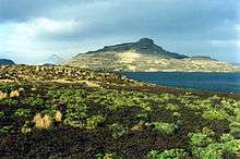
The islands are part of the Southern Indian Ocean Islands tundra ecoregion that includes several subantarctic islands. Plant life is mainly limited to grasses, mosses and lichens, although the islands are also known for the indigenous, edible Kerguelen cabbage, a good source of vitamin C to mariners. The main indigenous animals are insects along with large populations of ocean-going seabirds, seals and penguins.[22]
The wildlife is particularly vulnerable to introduced species and one particular problem has been cats. The main island is the home of a well-established feral cat population, descended from ships' cats.[23] They survive on sea birds and the feral rabbits that were introduced to the islands. There are also populations of wild sheep (Ovis orientalis orientalis) and reindeer.
In the 1950s and 1960s, Edgar Albert de la Rue, a French geologist began the introduction of several species of salmonids. Of the seven species introduced, only brook trout Salvelinus fontinalis and brown trout Salmo trutta survived to establish wild populations.[24]
Coleoptera
- Carabidae
- Oopterus soledadinus [adventive]
- Hydraenidae
- Meropathus chuni [endemic]
In popular culture
The islands figure in a number of books. The title character in Edgar Allan Poe's 1838 novel, The Narrative of Arthur Gordon Pym of Nantucket, visits the islands.[25] Henry De Vere Stacpoole set his 1919 novel The Beach of Dreams on the islands.[26] The fifth book in Patrick O'Brian's Aubrey–Maturin series, published in 1978, is entitled Desolation Island.[27]
The islands inspired the 2008 song The Loneliest Place on the Map by singer/songwriter Al Stewart.[28]
See also
- Administrative divisions of France
- French overseas departments and territories
- Islands controlled by France in the Indian and Pacific oceans
- List of Antarctic and subantarctic islands
References
- 1 2 Official organisational chart
- ↑ Oxford English Dictionary
- ↑ "Kerguelen Islands". Encyclopedia Britannica. Retrieved 22 October 2016.
- 1 2 Sea Level Measurement and Analysis in the Western Indian Ocean, UNESCO Intergovernmental Oceanographic Commission
- ↑ "Kerguelen – yves trémarec – james cook – asia – hillsborough – rhodes". Kerguelen-voyages.com.
- 1 2 The Three Voyages of Captain James Cook Round the World, volume 5, James Cook, pub. Longman, Hurst, Rees, Orme, et Brown, Londres, 1821, pp. 146–151.
- ↑ Whales, whaling, and ocean ecosystems, James A. Estes
- ↑ Clayton, Jane M. (2014) Ships employed in the South Sea Whale Fishery from Britain: 1775-1815: An alphabetical list of ships. (Berforts Group), p.141. ISBN 978-1908616524
- ↑ "Kerguelen – morell – john nunn – ross – ofley – challenger – fuller – eure – bossière". Kerguelen-voyages.com.
- ↑ Nunn, John (1850). Narrative of the Wreck of the "Favourite" on the Island of Desolation: detailing the adventures, sufferings and privations of J. Nunn, an historical account of the Island, and its whale and seal fisheries. London: William Edward Painter. p. 236. Retrieved 29 November 2014.
- ↑ Quanchi, Max (2005). Historical Dictionary of the Discovery and Exploration of the Pacific Islands. The Scarecrow Press. p. 87-88. ISBN 0810853957.
- ↑ Exploring Polar Frontiers, p. 346, William James Mills, 2003
- ↑ "19th Century History of Kerguelen Island, South Indian Ocean". Btinternet.com. 29 June 2003. Archived from the original on 30 July 2012. Retrieved 30 March 2012.
- ↑ "Calotte Glaciaire Cook". Mapcarta. Retrieved 25 September 2016.
- ↑ Kauffmann, Jean-Paul (2001). Voyage to Desolation Island. Random House. pp. 77–78. ISBN 1860469264. Retrieved 18 December 2012.
- ↑ (French) bases temporaires de lancements de fusées
- ↑ article by Roland Shlich (Research Manager at the CNRS)
- ↑ UT Austin scientist plays major role in study of underwater "micro-continent". Retrieved on 29 June 2007
- ↑ Sci/Tech 'Lost continent' discovered Retrieved on 29 June 2007
- ↑ Peel, M. C. and Finlayson, B. L. and McMahon, T. A. (2007). "Updated world map of the Köppen–Geiger climate classification". Hydrol. Earth Syst. Sci. 11: 1633–1644. doi:10.5194/hess-11-1633-2007. ISSN 1027-5606. (direct: Final Revised Paper)
- ↑ "Le climat à Port aux Français (en °C et mm, moyennes mensuelles 1971/2000 et records depuis 1973) sur MeteoStats".
- ↑ "Southern Indian Ocean Islands tundra". Terrestrial Ecoregions. World Wildlife Fund.
- ↑ Minou, ce dangereux prédateur
- ↑ Newton, Chris (2013). "The Monsters of Kerguelen". The Trout's Tale – The Fish That Conquered an Empire. Ellesmere, Shropshire: Medlar Press. pp. 161–170. ISBN 978-1-907110-44-3.
- ↑ Sharma, Raja (2016). Ready Reference Treatise: The Narrative of Arthur Gordon Pym of Nantucket. Lulu Press. p. 41. ISBN 9781329804036.
- ↑ Stilgoe, John R. (2003). Lifeboat. University of Virginia Press. p. 36. ISBN 9780813922218.
- ↑ O'Brian, Patrick (1978). Desolation island (Jack Aubrey vol 5). Collins. ISBN 9780006499244.
- ↑ Barnard, Jason; Stewart, Al (2016). "Al Stewart – Past, Present and Future". The Strange Brew. Retrieved April 12, 2016.
External links
| Wikivoyage has a travel guide for Kerguelen. |
| Wikimedia Commons has media related to Kerguelen Islands. |
| The Wikibook Geography of France has a page on the topic of: Kerguelen Islands |
- Official website (French)
- Official website (French)
- "Cartography of the Kerguelen". Archived from the original on 13 April 2003. Retrieved 2007-04-02.Including a toponymy index.
- Personal site with many pictures
- Rocket launches on the Kerguelen Islands
- "South Atlantic & Subantarctic Islands site, Kerguelen Archipelago page". Archived from the original on 29 November 2012.
Districts of the French Southern and Antarctic Lands | ||
|---|---|---|
| ||
| |||||||||||||||||||
| |||||||||||||||||||
| |||||||||||||||||||
Coordinates: 49°15′S 69°10′E / 49.250°S 69.167°E