Île-de-Bréhat
| Bréhat Île-de-Bréhat Enez-Vriad | |
|---|---|
|
Port-Clos landing stage at low tide | |
 Bréhat | |
|
Location within Brittany region  Bréhat | |
| Coordinates: 48°50′49″N 2°59′55″W / 48.8469°N 2.9986°WCoordinates: 48°50′49″N 2°59′55″W / 48.8469°N 2.9986°W | |
| Country | France |
| Region | Brittany |
| Department | Côtes-d'Armor |
| Arrondissement | Saint-Brieuc |
| Canton | Paimpol |
| Government | |
| • Mayor (2014–2020) | Patrick Huet |
| Area1 | 3.09 km2 (1.19 sq mi) |
| Population (2011)2 | 400 |
| • Density | 130/km2 (340/sq mi) |
| Time zone | CET (UTC+1) |
| • Summer (DST) | CEST (UTC+2) |
| INSEE/Postal code | 22016 / 22870 |
| Elevation | 0–34 m (0–112 ft) |
| Website | Site de la mairie de l'île de Bréhat |
|
1 French Land Register data, which excludes lakes, ponds, glaciers > 1 km² (0.386 sq mi or 247 acres) and river estuaries. 2 Population without double counting: residents of multiple communes (e.g., students and military personnel) only counted once. | |

Bréhat (French: Île-de-Bréhat, Breton: Enez Vriad) is an island and commune located near Paimpol, a mile off the northern coast of Brittany. Administratively, it is a commune in the Côtes-d'Armor department in northwestern France.
Bréhat is actually an archipelago composed of two main islands, separated only at high tide, and many smaller ones. It is famous for its pink granite rocks, very mild micro-climate and Mediterranean vegetation, due to the warm Gulf Stream coming from across the Atlantic.
Many day-trippers come to Brehat every day by the ferry service (les Vedettes de Bréhat) and visit the main tourist attractions, the Paon & Rosedo lighthouses, the St-Michel chapel, the Guerzido beach, the Birlot water-mill and the Verrerie of Bréhat.
 Bréhat island's enclosed harbour, at high tide |
Climate
| Climate data for Île-de-Bréhat (1961–1990) | |||||||||||||
|---|---|---|---|---|---|---|---|---|---|---|---|---|---|
| Month | Jan | Feb | Mar | Apr | May | Jun | Jul | Aug | Sep | Oct | Nov | Dec | Year |
| Average high °C (°F) | 8.9 (48) |
9.0 (48.2) |
10.4 (50.7) |
11.9 (53.4) |
14.6 (58.3) |
17.1 (62.8) |
19.4 (66.9) |
19.9 (67.8) |
18.7 (65.7) |
15.9 (60.6) |
12.0 (53.6) |
10.0 (50) |
14.0 (57.2) |
| Daily mean °C (°F) | 6.8 (44.2) |
6.8 (44.2) |
8.0 (46.4) |
9.4 (48.9) |
11.9 (53.4) |
14.4 (57.9) |
16.6 (61.9) |
17.1 (62.8) |
16.0 (60.8) |
13.5 (56.3) |
10.0 (50) |
8.0 (46.4) |
11.5 (52.7) |
| Average low °C (°F) | 4.7 (40.5) |
4.6 (40.3) |
5.5 (41.9) |
6.9 (44.4) |
9.2 (48.6) |
11.7 (53.1) |
13.8 (56.8) |
14.3 (57.7) |
13.4 (56.1) |
11.1 (52) |
7.9 (46.2) |
6.0 (42.8) |
9.1 (48.4) |
| Average precipitation mm (inches) | 85.0 (3.346) |
69.5 (2.736) |
62.5 (2.461) |
45.0 (1.772) |
56.0 (2.205) |
39.6 (1.559) |
36.1 (1.421) |
36.3 (1.429) |
51.5 (2.028) |
69.0 (2.717) |
88.7 (3.492) |
83.5 (3.287) |
722.8 (28.457) |
| Average relative humidity (%) | 87 | 85 | 85 | 85 | 86 | 87 | 87 | 86 | 86 | 86 | 85 | 85 | 86 |
| Mean monthly sunshine hours | 61.7 | 87.3 | 134.5 | 180.3 | 224.3 | 223.2 | 238.2 | 220.9 | 169.8 | 122.7 | 72.3 | 56.3 | 1,791.5 |
| Source: Infoclimat.fr[1] | |||||||||||||
Population
| Historical population | ||
|---|---|---|
| Year | Pop. | ±% |
| 1793 | 1,318 | — |
| 1800 | 1,475 | +11.9% |
| 1806 | 1,444 | −2.1% |
| 1821 | 1,488 | +3.0% |
| 1831 | 1,550 | +4.2% |
| 1836 | 1,483 | −4.3% |
| 1841 | 1,519 | +2.4% |
| 1846 | 1,941 | +27.8% |
| 1851 | 1,357 | −30.1% |
| 1856 | 1,348 | −0.7% |
| 1861 | 1,202 | −10.8% |
| 1866 | 1,212 | +0.8% |
| 1872 | 1,114 | −8.1% |
| 1876 | 1,059 | −4.9% |
| 1881 | 1,172 | +10.7% |
| 1886 | 1,086 | −7.3% |
| 1891 | 1,012 | −6.8% |
| 1896 | 984 | −2.8% |
| 1901 | 995 | +1.1% |
| 1906 | 1,062 | +6.7% |
| 1911 | 1,016 | −4.3% |
| 1921 | 977 | −3.8% |
| 1926 | 980 | +0.3% |
| 1931 | 959 | −2.1% |
| 1936 | 830 | −13.5% |
| 1946 | 855 | +3.0% |
| 1954 | 843 | −1.4% |
| 1962 | 700 | −17.0% |
| 1968 | 653 | −6.7% |
| 1975 | 553 | −15.3% |
| 1982 | 511 | −7.6% |
| 1990 | 461 | −9.8% |
| 1999 | 421 | −8.7% |
| 2008 | 444 | +5.5% |
| 2011 | 400 | −9.9% |
Inhabitants of Île-de-Bréhat are called bréhatins in French.
Sights
- Héaux de Bréhat lighthouse
- Rosedo lighthouse
- Chapelle Saint Michel
- Paon lighthouse
- Chapelle Keranroux
- Verrerie of Brehat
People linked to Île-de-Bréhat
- Marc Chagall, (1887–1985), painted La fenêtre sur l'Ile de Bréhat, 1924, kept at Vereinigung Zürcher Kunstfreunde.[2]
- Goudji, (1941–), the Georgian-born French sculptor and goldsmith, frequently resides in Bréhat ; in 2008 he offered an item and participated in an auction to restore local religious monuments
See also
- Communes of the Côtes-d'Armor department
- André César Vermare Sculptor of war memorial
References
- ↑ "Normes et records 1961-1990: Ile de Bréhat, Côtes-d'Armor(22), 25m" (in French). Infoclimat. Archived from the original on December 9, 2008. Retrieved January 9, 2016.
- ↑ Marc Chagall at Vereinigung Zürcher Kunstfreunde
External links
| Wikimedia Commons has media related to Île-de-Bréhat. |
- Mairie de Bréhat (Island town home)
- Vedettes de Bréhat (ferry boat company)
- Tourism in Brehat
- French Ministry of Culture list for Île-de-Bréhat (French)
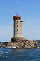 La Croix Lighthouse
 Paon Lighthouse
 Chapelle St Michel
 Chapelle Keranoux
 St Michael's chapel