West and East Mitten Buttes

| West Mitten Butte | |
|---|---|
| Highest point | |
| Elevation | 6,176 ft (1,882 m) NGVD 29[1] |
| Prominence | 856 ft (261 m) [1] |
| Coordinates | 36°59′27″N 110°05′46″W / 36.9908349°N 110.096237°W [2] |
| Geography | |
| Location | Monument Valley, Arizona, U.S. |
| Topo map | USGS Mitten Buttes |
| East Mitten Buttes | |
|---|---|
| Highest point | |
| Elevation | 6,226 ft (1,898 m) [3] |
| Prominence | 1,026 ft (313 m) [3] |
| Coordinates | 36°59′18″N 110°04′11″W / 36.988335°N 110.0698471°WCoordinates: 36°59′18″N 110°04′11″W / 36.988335°N 110.0698471°W [4] |
| Geography | |
| Location | Monument Valley, Arizona, U.S. |
| Topo map | USGS Mitten Buttes |
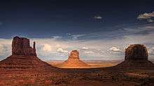
West and East Mitten Buttes (also known collectively as The Mittens) are two distinctive geological features found within the Monument Valley Navajo Tribal Park in northeast Navajo County, Arizona. When viewed from the south, the buttes appear to be two gigantic mittens with their thumbs facing inwards.
The two buttes are about 0.6 miles (0.97 km) from the Arizona–Utah state line and West Mitten Butte is 1.1 miles (1.8 km) northeast of the park headquarters.[5] The summit of West Mitten Butte is 6,176 feet (1,882 m)[1] and East Mitten Butte is 6,226 feet (1,898 m)[3] in elevation.
The Mittens form a triangle with Merrick Butte about 2/3 of a mile to the south and, with Sentinel Mesa.
The buttes are made of three principal rock layers. The lowest layer is Organ Rock Shale, the middle is de Chelly Sandstone, and the top layer is the Moenkopi Formation capped by Shinarump Conglomerate.
References
- 1 2 3 "West Mitten Butte, Arizona". Peakbagger.com. Retrieved 2016-08-22.
- ↑ "West Mitten Butte". Geographic Names Information System. United States Geological Survey. Retrieved 2016-08-22.
- 1 2 3 NGVD 29"East Mitten Butte, Arizona". Peakbagger.com. Retrieved 2016-08-22.
- ↑ "East Mitten Butte". Geographic Names Information System. United States Geological Survey. Retrieved 2016-08-22.
- ↑ Arizona Atlas & Gazetteer, De Lorme, 4th ed., 2001, p. 26 ISBN 0-89933-325-7
| Wikimedia Commons has media related to West and East Mitten Buttes. |